Sunday, November 28, 2010
Awesome Photos from Vortex 2
Awesome post on Ryan McGinnis's blog, featuring 25 favorite photos from his recent tour with the 2010 Vortex 2 project. Be sure to click on the photos to enlarge them to their full splendor!
Cancun Waterspout Video
Interesting video on YouTube capturing a rather large waterspout as it moved onshore in Cancun earlier this month. Toward the end of the video, if you look closely you can see people sitting out on their beach chairs, completely oblivious to what was approaching. Fortunately for them, the winds associated with waterspouts are typically much weaker as compared to tornadoes.
You'll also note the lack of any kind of "funnel cloud" associated with the circulation. This is also fairly unusual for waterspouts, which typically have a pretty ominous looking condensation funnel associated with them. To illustrate this point, please see some other photos of waterspouts below:


You'll also note the lack of any kind of "funnel cloud" associated with the circulation. This is also fairly unusual for waterspouts, which typically have a pretty ominous looking condensation funnel associated with them. To illustrate this point, please see some other photos of waterspouts below:


Thursday, November 25, 2010
What A Difference An Hour Makes!
As noted in my last post, one hour ago it was 83.2 degrees at my home near Kyle. One hour later, it is 60.2 degrees. Below are reflectivity and velocity images as the front neared the New Braunfels radar site a moment ago:


Had to pump up the flames on my smoker to regulate the temperature thanks to the 20 degree drop outside. Hopefully we're still on for 5pm eating time! I'll have a bunch of unhappy campers if it's not done!
Frontal Passage at Kyle, TX

At 2:25 pm CST, the cold front was advancing Southward, and had passed through my home near Kyle, TX (you can see the front on the radar image above). The temperature at 2:25 was 83.2 degrees. I'll post an update in about an hour to see how far down we will have come....
Let the fun and games regulating the outdoor smoker temperature begin!
Central Texas Cold Front Update

As advertised for the past week, a strong cold front is advancing southward through Texas at early afternoon. You can actually see the front on the above radar image from radar site near Killeen (note the fine line extending from between Johnson City & Austin, through Austin to near Caldwell.
Temperatures are in the lower 80s ahead of the front, and drop sharply into the 50s behind it (note the surface observations overlaid on the radar image). This dramatic change will spread Southward along the I-35 corridor from Austin to San Antonio over the next couple of hours.
If you're like me and are smoking a turkey outside, prepare to boost the heat a bit as outdoor temperatures begin to fall over the next couple of hours.
Showers and a few thunderstorms are breaking out ahead of the front over east-central Texas. Isolated activity is possible further southwest along the front as well, as the afternoon progresses.
Macy's Thanksgiving Day Parade

It looks like the annual big event will dodge a bullet (weatherwise) this year.
Cloudy skies, light winds and temperatures in the lower 40s can be expected during the parade. Rain, heavy at times, is likely later this evening and into tonight.
Happy Thanksgiving 2010!

I hope that you and your family have a very happy, healthy & safe Thanksgiving!
Wednesday, November 24, 2010
Severe Weather Update
A tornado watch was issued earlier this afternoon for portions of Oklahoma, Kansas, Missouri & Arkansas. A tornado warning is currently in effect for one of the thunderstorms within the watch, located just Northeast of Cross Timbers, MO. Below is the latest reflectivity radar image from the Springfield, MO radar:


And here is the latest storm relative velocity image from the same radar site:

Note where the red and green colors meet, right between Cross Timbers and Climax Springs. Remember, the green indicates wind motion toward the radar, while the reds show motion away from the radar (and the radar is located just off of the bottom left corner of the screen). This indicates strong circulation associated with the possible tornado. The purplish/pinkish outline shows the tornado warning area as issued by the Springfield NWS office.
Further to the Southwest, the line of storms has not yet reached severe limits over southwest Missouri & northeast Oklahoma, however, frequent cloud to ground lightning is taking place within much of the line of storms, as shown by the latest Tulsa radar image shown below, with lightning data overlain:

The tornado watch continues for much of this region until 10pm CST. Residents and travelers across the region should remain alert for rapidly changing weather conditions.
Tornado Watch Issued...

A tornado watch has been issued for portions of Oklahoma, Kansas, Missouri and Arkansas.
Thunderstorms are developing across the region and are likely to intensify later this afternoon & into this evening.
Tornadoes, large hail & damaging winds can be expected from the stronger storms.
Severe Weather Update

As mentioned in my post on travel weather earlier today, severe thunderstorms are likely across portions of extreme southeast Kansas, Oklahoma, Arkansas and Missouri later this afternoon and evening. Above is the latest severe weather outlook from the SPC.
Tornadoes, large hail and damaging winds will be possible with any of this activity.
Residents of the above region, as well as those with travel plans through the region, should remain alert later this afternoon & evening and listen for the latest updates, watches and warnings.
Today's Travel Weather

Today is typically the busiest travel day of the year. Fortunately, there won't be any widespread bad weather across much of the nation, however there will be a few active spots....
As you can see on the above forecast map for today (from the HPC), severe thunderstorms are possible across portions of Oklahoma, Arkansas and Missouri. This will include a risk of tornadoes late this afternoon and evening.
Rain and thunderstorm activity across portions of the mid-Mississippi River Valley and Midwest could pose a flash flooding threat from southeast Missouri into southwest Ohio.
Heavy snows are possible across portions of North Dakota and the central Rockies. Ice and snow mixed are possible from portions of Iowa, eastward into central & northern portions of Illinois and Indiana.
A strong cold front will continue progressing Southward through the central & northern Plains today, bringing much colder and windy conditions in its wake.
Tuesday, November 23, 2010
Pre-Thanksgiving Blast on Track!
Heavy snow (with blizzard to near blizzard conditions) is forecast for a large portion of the central and northern Rockies tomorrow into early Thanksgiving. Below is the latest HPC forecast showing the likelihood of greater than 4 inches of snow:


When buffeted by 50+ mph winds, blizzard conditions can be expected in many areas, as highlighted by the brighter orange areas (blizzard warning) on the map below over portions of Utah, Nevada, Idaho and Colorado:

All of the above will be taking place compliments of the strong upper level storm system and surface cold front that we've been forecasting to bring much colder conditions to the Plains & Midwest by Thanksgiving Day. That forecast still appears to be on track, with the latest surface forecast map for Thursday shown below:

Showers & thunderstorms can be expected along and ahead of the front on Thanksgiving Day across portions of far South & Southeast Texas as well as the Southeast, mid-Atlantic and Northeast.
The above map is valid for 6pm CST (7pm EST) on Thanksgiving Day. If the above timing verifies, the weather should be at least somewhat cooperative (rain-wise) for the Macy's Thanksgiving Day parade in New York on Saturday morning. The afternoon, on the other hand, will be quite wet.
Sunday, November 21, 2010
Wild Weather For Thanksgiving
Ahh yes...nothing like putting up Christmas lights on the outside of the house in shorts and a short-sleeved shirt. That's exactly what I was doing here in southcentral Texas today, where the afternoon high approached 80, with a dew point near 70. It felt downright tropical outside! Disgusting....
Well, changes are on the way, not only for my area, but most of the nation by Thanksgiving Day. Below is the latest HPC surface forecast map valid for 6am CST on Thanksgiving Day. I have highlighted areas with the greatest chance of rain (in light green) and snow (in light blue). Otherwise, expect windy and much cooler conditions across most of the Plains & Midwest, behind a strong cold front:

Well, changes are on the way, not only for my area, but most of the nation by Thanksgiving Day. Below is the latest HPC surface forecast map valid for 6am CST on Thanksgiving Day. I have highlighted areas with the greatest chance of rain (in light green) and snow (in light blue). Otherwise, expect windy and much cooler conditions across most of the Plains & Midwest, behind a strong cold front:

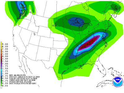
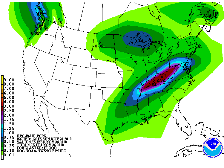
Heaviest rainfall is likely to occur along and South of the warm front across parts of the Ohio and Tennessee Valley areas. Below is the latest total rainfall forecast from the HPC, again valid Thanksgiving Day:
Meanwhile, locally heavy snows will be possible across portions of the upper Midwest, mainly from Minnesoate into adjacent portions of Wisconsin and Canada.
More on this in the coming days...
Friday, November 19, 2010
Thanksgiving Day Cooldown

The above is the latest forecast surface weather map valid at 6am CST on Thanksgiving Day. The HPC is forecasting a strong cold front to bring much colder conditions to the Plains & Midwest for Thanksgiving Day.
If the timing of the front verifies, fairly widespread rains can also be expected ahead of the front on Thanksgiving Day, from Florida & the southeast up along the Eastern Seaboard into New England.
Sunday, November 14, 2010
Awesome Tornado Photos from France
Yes, I said France - and in November, no less. On the 10th near the islands of Port Cros and Levant, a rare and strong supercell storm produced a very picturesque tornado / waterspout. See the series of photos below, taken by Frederic Capoulade:


Here is a view of the nearest radar, depicting the parent supercell storm at about 07:30 local time:

According to analysis by Keranous.org, (get that French translator ready), "Supercell, shown circled in red on the radar cons of 08h local (source wetter24.de) presented supercell characteristics for about two hours, with a phase of maturity particularly clear for 35 to 40 minutes. The mesocyclone passed the zenith of the island of Levant to 7:30 local."
According to the site, the last time a tornado was observed on the French coast was on July 16, 2009.
Saturday, November 13, 2010
First Significant Snowfall of the Season

The first major snowfall of the season (outside of mountainous areas) is beginning to wind down across Minnesota this evening. The picture above was taken in Woodbury, MN earlier today (via Chikage Windler at KSTP in Minneapolis). Below is the latest image from the Minneapolis, MN area radar site:

Heavy snowfall totals of 6-12 inches are widespread across the region, as seen on the latest storm report map below (click to enlarge):

Keep in mind that the above totals took place on relatively warm ground (because it is so early in the season). Just imagine if a storm of the same intensity would have moved through the region a month or two later when the ground was colder - we'd be talking about massive snowfall amounts for sure!
A strong area of low pressure is racing Northeast across the region, accompanied by strong, gusty winds, rapidly falling temperatures and snow. It shouldn't take you very long to locate the center of low pressure by looking at the wind barbs on the latest surface map, below:

As the low lifts out to the North/Northeast over the next 12 hours, the heavier snow bands will shift from the arrowhead of Minnesota on into adjacent portions of Canada (although snowfall rates are likely to be less intense than earlier this afternoon across Minnesota, as the upper level energy that enhanced the snowfall has already moved out of the region).
Thursday, November 11, 2010

Tuesday, November 9, 2010
Another Major Pattern Change in the Offing?
The computer forecast models have been hinting at a major pattern shift for the first part of next week, including the possibility of a major cold outbreak for much of the central third of the nation later in the week. The Climate Prediction Center (CPC) picked-up on this over the weekend, and reiterated it in their latest outlook issued today:


In case you're unfamiliar with how to read the above chart, it is showing "anomalies" or departure from "normal" temperature conditions. The valid period is November 15th-19th. As you can see, the CPC is forecasting a 70% chance of below normal temperatures in the darkest blue region, and a 60% and 50% chance in the correspondingly less dark blue regions.
The computer models continue to show cooler conditions spreading Southward through the Nation beginning this weekend, with increasingly stronger "bursts" of cold air well into next week.
Below is the latest surface weather map (as forecast by the HPC) for Tuesday morning, November 16th:

As you can see, the first cold front is shown entering the Gulf Coast region, with another, stronger front entering the Northwest (with yet another depicted surging Southward over central Canada).
There are several other scenarios that could unfold next week, but I'm going to sit back and see how the computer model forecasts evolve over the next few days before posting more detailed information...
Saturday, November 6, 2010
Daylight Savings Time Ends Tonight

Ahhhhh yes, a crisp 36 degrees the past 2 mornings in a row here at my home near Kyle, TX. This, along with the change back to "Standard Time" tonight must mean it's somewhere around the first Sunday of November. Isn't it awesome when the calendar and the weather match up once in awhile?
Be sure to remember to set your alarm clock for 2 a.m., then get up and turn all of your clocks back to 1 a.m. on Sunday morning. Sure, you might be a little groggy when you drag into church, but at least you'll be on time (unlike the poor folks that forgot to make the change).
Wait a minute...I guess you could just turn the clocks back before you go to bed tonight, instead of waking up at 2 and doing it. Hat tip to my wife on that one.
All poor attempts at humor aside, just who's "bright" idea was it to institute this practice? Well, "modern" daylight savings time was first proposed in 1895 by that wild, wacky British guy named George Vernon Hudson. Vern was an astronomer who also liked to run around collecting bugs. Figuring that a few extra hours of daylight would yield even more specimens for his collection - badda boom, badda bing - Daylight Savings Time was invented.
Even though I'm a severe weather nut, I personally love winter time as well. The shift back to standard time always brings that good ol' winter time feeling rushing back in again, even here in the seemingly anti-wintry region of southcentral Texas.
Also, it reminds me to kick-it into high gear on preparing my Christmas light display. The annual family tradition is lit-up on Thanksgiving Evening each year, which means I only have 19 short days to get this show on the road.
So with that, happy end to Daylight Savings...and don't be an hour ahead of schedule all day tomorrow!
Thursday, November 4, 2010
Strong Winds & Heavy Rains to Pound Haiti

Though not currently a hurricane, Tropical Storm Tomas will still bring potentially devastating rains and floods to Haiti, the impoverished region that is still trying to recover from the massive earthquake earlier this year.
The above satellite image shows the center of Tomas about 305 miles Southwest of Port Au Prince, Haiti, as of 8am EDT this morning. The system is moving toward the North/Northwest at 6 mph. Tomas is currently forecast to make a turn toward the North and then Northeast over the next 24-48 hours.

On the present forecast track, the center of Tomas will pass very near Haiti tonight. Outer rainbands are already beginning to affect the area and heavy rains will increase throughout the day today. Strong wind gusts to tropical storm force can also be expected later today and tonight. It is possible that Tomas will intensify to a minimal hurricane later tonight. At this time however, it appears as though the main impacts on Haiti will be tropical storm force winds and very heavy, flooding rains (and resulting mudslides).
Please keep the people of Haiti and that general region in your thoughts & prayers. They were already trying to fight back from a disaster of epic proportions, and Tomas could only make things worse once again.
Subscribe to:
Posts (Atom)