A large tornado struck the Emilia Romagna region of Italy earlier today (local time). The above video was recently posted on YouTube and the still photo below was posted on twitter:
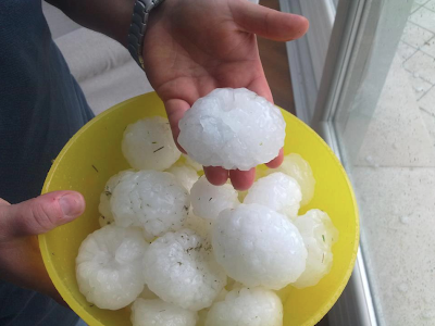
One of the same supercell thunderstorms also produced very large hail across the area (which is not typical of this region):
One of the same supercell thunderstorms also produced very large hail across the area (which is not typical of this region):
The radar snapshot below shows the same types of supercell thunderstorm signatures across northern Italy today that we'd typically see here in the central U.S.!
...and a related visible satellite picture shows "overshooting tops" on at least 3 storms, which signifies very large hail (as confirmed by the picture above):
You can read more about the event here.
For more information from 'The Original Weather Blog', including shorter, more frequent posts during rapidly changing weather events, please be sure to follow me on facebook and twitter:


No comments:
Post a Comment