A vigorous disturbance moving West off of the African coast has just been named Tropical Storm Philippe, the 16th named storm of the 2011 Atlantic season. A visible satellite image recently taken just as the sun was setting over Africa shows the nice swirl pattern associated with the system:

The infrared satellite view of the system is below...



The infrared satellite view of the system is below...

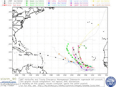
Philippe is likely to be what we call a "fish storm", meaning that only our friends of the aquatic persuasion are likely to be affected by the system (and any ships out at sea, of course). Computer forecast models currently steer the system toward the Northwest and out into the open Atlantic in a relatively short period of time:

...and this trend is echoed by the official National Hurricane Center (NHC) forecast as shown below:

Meanwhile, several hundred miles back toward the West, Tropical Storm Ophelia remains rather disorganized, with the latest hurricane hunter aircraft pass having a difficult time locating the center of the system. You can see Ophelia on the latest water vapor satellite wide shot of the tropics below (click to enlarge):

As alluded to in a post a couple of days ago, Ophelia's greatest threat may be to Bermuda (though still as a Tropical Storm rather than a hurricane) later in the coming week, but we still have plenty of time to monitor her progress in the meantime:

We've also seen a flare-up in thunderstorm activity over the Bahamas, about 175 miles East/Southeast of Cape Canaveral, Florida during the last 12-24 hours. You can see the system on the satellite wide shot above, and here is a close-up visible and infrared look below:


The computer models are nearly unanimous in tracking the system Northward, with it passing just East of the outer banks during the day Monday. The question is, will it organize into a tropical depression or storm by that time?

At this time, conditions in the middle and upper-levels of the atmosphere do not support rapid organization or intensification of the system, however it does bear watching, especially for the next 24 hours as it resides over the very warm waters of the northern Bahamas.
Way back on September 13th I made this post and remarked about how the GFS model had been persistent in showing a tropical system over Florida on or about 9-27-11 (the last graphic toward the very end of the post).

I think the disturbance currently over the Bahamas and just East of Florida has to be the one that the model was alluding to. Fortunately, (for Florida anyway) it does not appear as though the system will be nearly as strong as the model had depicted (and it will also remain East of Florida and the southeast U.S. coast the way it looks now). Still, not too shabby for a computer model prediction in the tropics nearly 2 weeks in advance.
As I've mentioned before, you have to classify such long range model forecasts as "information only", as the exact location and intensity of such a system is very difficult to predict, especially that far out into the future. At least it gives you an idea as to where you should focus your attention and monitor for potential development in a given timeframe...
Speaking of long range model hints at tropical development, a natural question might be: is there anything showing up in the long range right now? The short answer right now is a simple "No", but I'll keep my eye on it for you...
If you enjoy reading 'The Original Weather Blog', please be sure to "like" our facebook page!


