Showing posts with label Weather In the News. Show all posts

Friday, October 4, 2013

Potent Round of Severe Weather Likely Later Today/Tonight...


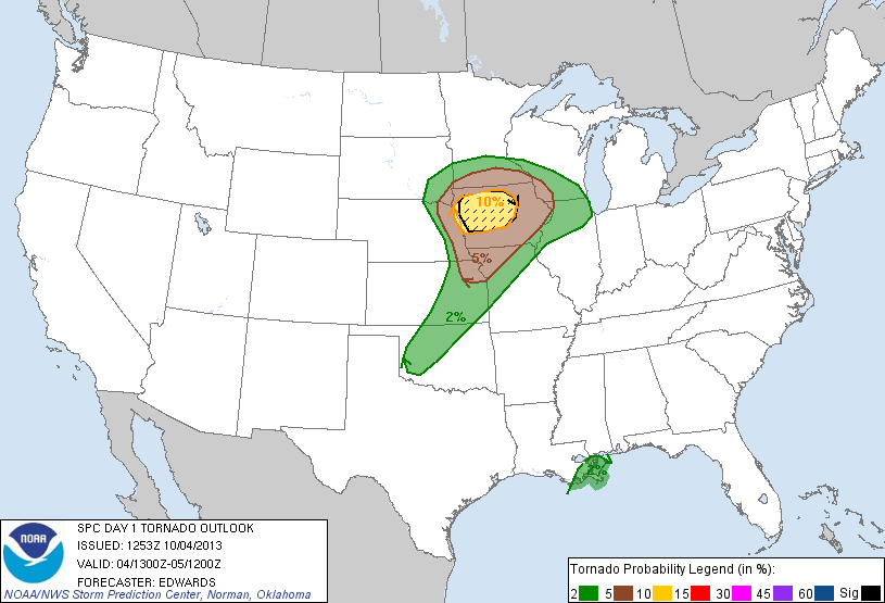
After a preview yesterday evening in southeast Nebraska, severe weather activity has waned a bit over the last several hours.  However, folks in the upper Mississippi Valley and portions of the Midwest should not let their guards down - an even more potent threat of severe weather is on tap later this afternoon into this evening and tonight.

Above is the latest severe weather outlook for today and tonight, and is the portion that specifically addresses the potential for tornadoes, which will be highest within the brown and yellow shaded areas.  A strong tornado or two is also possible, mainly within the black hatched area.

A threat for large hail and damaging winds will extend well to the South into portions of Oklahoma and northwest Texas as well, with some of the hail likely to exceed 2 inches in diameter in the black hatched areas on this image:


It's been awhile since we've seen a pronounced severe weather threat across a good chunk of the nation, so please be sure to keep an eye to the sky and listen for local updates and warnings as the afternoon and evening progresses.

Unfortunately, a good deal of the activity will take place after dark and into tonight.  If you live across this region, please make sure that you have a way to receive weather warnings at night.


For more information from 'The Original Weather Blog', including shorter, more frequent posts during rapidly changing weather events, please be sure to follow me on facebook and twitter:


Wednesday, October 2, 2013

Tropical System Forming Near Cuba Bears Watching...


The tropical system forming just Southwest of the Western tip of Cuba (as shown in the visible satellite image above) is becoming much better organized as of early afternoon today.

I fully expect this system to be named a Depression or Tropical Storm later today.

This system could eventually impact portions of the U.S. Gulf Coast, most likely from Mississippi on Eastward:


There are many variables still at play here, but at this time it appears the most likely U.S. impacts would take place during the 2nd half of this weekend into the first part of next week.

If you live along the U.S. Gulf Coast in the indicated areas, please keep an eye on this system over the coming days.  We'll post pertinent information as it becomes better organized...

For more information from 'The Original Weather Blog', including shorter, more frequent posts during rapidly changing weather events, please be sure to follow me on facebook and twitter:


Thursday, September 26, 2013

First "Big" Snow of the Season in Butte, MT


...where 18 inches of the white stuff fell overnight and this morning (photo taken just South of town, via twitter).

The latest run of the ECMWF ("European") computer forecast model calls for the first locally heavy snows of the season to spread Southeast across much of the remainder of the central and northern Rockies over the next 5-10 days:


For more information from 'The Original Weather Blog', including shorter, more frequent posts during rapidly changing weather events, please be sure to follow me on facebook and twitter:


Saturday, September 21, 2013

"Hurricane Drought" Continues In the Atlantic/Gulf of Mexico...

...and the only people complaining about it are a select few of the "usual suspects" in the mainstream media.

The system that I blogged about at the beginning of the week (or last weekend?) in the Gulf of Mexico is in the process of being absorbed by a cool front at this time, so it no longer poses a threat of organizing into a tropical system:


Moisture from this system as well as the remnants of a tropical system in the Pacific did produce widespread, beneficial rainfall across much of southcentral and eastern Texas on Thursday and Friday, with 3-6 inches deposited in a good chunk of the Edwards Aquifer recharge zone (which lies immediately to the West of the Austin/San Antonio corridor).

The image below is the storm total rainfall estimate from the dual-pol radar at the New Braunfels airport (between Austin and San Antonio, scale in inches at the left hand side):


So, what are the prospects for organized tropical weather in the upcoming week to 10 days?  Pretty low the way it looks right now, but we'll keep an eye on it...

For more information from 'The Original Weather Blog', including shorter, more frequent posts during rapidly changing weather events, please be sure to follow me on facebook and twitter:


Wednesday, September 18, 2013

Keeping an Eye on 1st Hurricane Potential of Season for U.S. Gulf Coast...


An area of disturbed weather is taking shape in the tropics near the Yucatan Peninsula today (red circled area on the visible satellite image above).  A Hurricane Hunter aircraft is scheduled to visit the region this afternoon, and this system is very likely to be named a Tropical Depression or Storm in the next 24-48 hours.

Computer model forecast solutions are all over the place with this system so far, but the general consensus in the last 12-18 hours is focusing on eventual, direct impacts on the northcentral or northeast Gulf Coast (and I agree with that assessment at this time):


The HWRF computer model is the most "bullish" so far, forecasting a hit by a formidable hurricane along the Florida coast late this weekend or early next week:


I would caution that "upgrades" in the HWRF model earlier this year seem to have resulted in its drastically "over forecasting" the intensity of just about every tropical system so far this season.  With that said, folks along the Gulf Coast need to keep a close eye on the development of this system, as some degree of impact from what will likely be a hurricane can be expected later this weekend or early next week.  The good news is that we still have some time to watch the system and gauge its true intensity before it directly impacts the U.S. coast.

In the meantime, moisture from this system will spread West into an already water logged eastern Mexico, as well as much of southern Texas and eventually the upper Texas and Louisiana coasts over the next 2-3 days.  The accumulated rainfall forecast from the WPC for the period today through 7pm CDT Saturday is shown below:


Again, if you live across the Gulf Coast from Texas through Florida, and especially the northcentral and northeastern parts of the Gulf Coast, please keep a very close eye on this system over the coming days. As always, you can track the progression of this and any other system with potential U.S. impacts on WeatherGuidance's Tropical Weather Homepage.

For more information from 'The Original Weather Blog', including shorter, more frequent posts during rapidly changing weather events, please be sure to follow me on facebook and twitter:


"Shocking" Photo Illustrates Lightning Danger at Outdoor Arenas


Lightning struck a tree literally feet away from the bleachers at a high school football game in Orlando, FL this past Friday.

For full details, please read the post on WeatherGuidance's blogpage.


For more information from 'The Original Weather Blog', including shorter, more frequent posts during rapidly changing weather events, please be sure to follow me on facebook and twitter:


Wednesday, September 4, 2013

Another Way to Look at Tornado Coverage

University of Florida Geography Professor James Elsner posted an interesting .gif animation on his blog recently.  It shows the approximate area of all U.S. tornadoes by year from 1950-2011, using a red circle centered on Oklahoma City as a point of reference:


I didn't choose 1988 for any particular reason, it just happened to be the year that was up on the rotation when I took the screen shot.  To view James' blog post with the full .gif animation, please go here.

For more information from 'The Original Weather Blog', including shorter, more frequent posts during rapidly changing weather events, please be sure to follow me on facebook and twitter:


Tuesday, September 3, 2013

From the "Don't Try This At Home" Dept. - Waterspout near Pensacola, FL Yesterday...


This boater (egged on by the videographer/passenger you can hear in the background) got way too close for comfort to a waterspout near Pensacola, FL yesterday.  

While waterspouts may seem weaker than a land-based tornado, they can very, very easily flip a boat over before you even know what hit you (literally).

For more information from 'The Original Weather Blog', including shorter, more frequent posts during rapidly changing weather events, please be sure to follow me on facebook and twitter:


Tuesday, August 27, 2013

Spectacular Photos of Haboob in Phoenix Yesterday Evening...

A dense, widespread haboob (fancy name for dust storm) took place in the Phoenix area yesterday evening.  Numerous (and many spectacular) photos of the phenomenon circulated throughout social media:

Jerry Ferguson (via twitter)

Rob Schumacher (via twitter)

Brian Pivar (via twitter)

Jeff Piotrowski (via twitter)

If you look closely at the last 2 photos, you can also see a slight "curl" in the flow along the left side of the dust plume.  That suggests downward air motion associated with a microburst or downburst at that particular location.

On the 2nd photo (from the top) you can see an airplane that had just taken off from Sky Harbor Airport ahead of the oncoming deluge (it was reportedly the last flight to depart prior to the arrival of the dust storm).

The sudden reduction of visibility and strong winds resulted in a 1 hour or more "holding pattern" above the airport for a time yesterday evening:


...during which time several flights decided to divert to Tucson or other nearby airports.

Strong wind gusts of 45-50 mph pushed the wall of dust from South to North through the region.  The following chart from the Phoenix Airport shows a peak wind gust near 50 mph just before 7:00 PM local time yesterday: 


Haboobs/dust storms are not necessarily uncommon in the area, especially with dry weather and strong, gusty winds there is plenty of "fuel" for the fire once things get going on a hot summer afternoon.

For more information from 'The Original Weather Blog', including shorter, more frequent posts during rapidly changing weather events, please be sure to follow me on facebook and twitter:


Thursday, July 25, 2013

Heavy Rain Tonight & Friday to Delay Storm Recovery in the Tulsa Area...


As mentioned at the time on facebook and twitter, severe thunderstorms produced widespread wind damage across the Tulsa area on Tuesday Night / early Wednesday morning.  


At one point early yesterday nearly 100,000 customers were without power in the Tulsa metro area.  That number has been shaved back to about 45,000 as of this morning, according to AEP/PSO:


The company is currently projecting that 95% of customers will have power back by 5pm on Saturday, however I'm concerned that weather conditions tonight and Friday are not being factored into the equation.

Unfortunately, at this time it appears that several rounds of shower and thunderstorm activity will take place across the area, with several high resolution computer forecast models suggesting 2-4 inches of rain likely for the period tonight through 7pm CDT on Friday:


Hopefully crews will get far enough ahead of the game today so that the impact will be minimized, but there seems little doubt that recovery efforts as whole will be slowed way down across the area on Friday.

For more information from 'The Original Weather Blog', including shorter, more frequent posts during rapidly changing weather events, please be sure to follow me on facebook and twitter:


"Catastrophic" Hail Damage in Burgundy Region of France


One or more rounds of severe thunderstorms with heavy rain and large hail pounded the Burgundy region of France on Tuesday afternoon (local time).  

Several vineyards are calling the damage "catastrophic", with some areas reporting 90% or more of their crops destroyed.  The photo above shows extensive damage (right half of the picture) to a vineyard in Beaune (photo courtesy Iain Doire).

Thunderstorms with hail of ping pong ball size or larger have plagued the region in recent years.  About this same time last year, nearly 60% of crops were impacted by another hail storm that struck the region.


Lower than average yields in recent years have resulted in increased pressure on prices, which are likely to continue to rise as a result of the latest incident.

For more information, see this article at thedrinksbusiness.com.  

For more information from 'The Original Weather Blog', including shorter, more frequent posts during rapidly changing weather events, please be sure to follow me on facebook and twitter:


Tuesday, July 23, 2013

Iowa: Ground Zero for Mammatus Yesterday Evening...

A round of severe thunderstorms produced widespread hail across a large chunk of central and northern Iowa yesterday afternoon and evening.

While some of the hail was destructive, the thunderstorm activity also produced beautiful mammatus clouds across the region, as shared by KWWL Chief Meteorologist Mark Schnackenberg (viewer photos):


Mammatus clouds are often associated with severe thunderstorms, particularly those which are prolific hail producers.  Their grouping, lobe like character are associated with turbulence bubbling up and down in the anvil or "belly" of a severe thunderstorm.

For more information from 'The Original Weather Blog', including shorter, more frequent posts during rapidly changing weather events, please be sure to follow me on facebook and twitter: