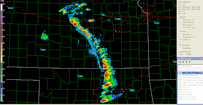
The above are recent images of the Wichita and Oklahoma City area radars, respectively.
As you can see by the rapid thunderstorm development along the boundary, the dryline has moved East of both Wichita and OKC, so those cities are now in the clear.
Any one of the above storms is capable of producing large hail, wind damage and a tornado.
The cells in Osage, Pawnee, Lincoln and Murray counties in Oklahoma look particularly dangerous. If you live in the path of these storms prepare to take tornado precautions on short notice. They are moving Northeastward currently, but will likely start to turn more toward the East over time as they mature.


No comments:
Post a Comment