***Update 7:35 PM CDT:
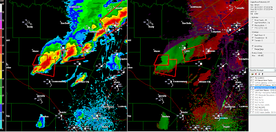
Rotation has weakened / diminished. Both storms still capable of large hail, strong gusty winds as they move East at 25 mph.:
Severe thunderstorm warning areas indicated by red polygons.
-----------------Original post below:
The above image was just taken from the NWS radar near New Braunfels, TX. It shows a pair of severe thunderstorms over the Texas Hill Country, in Mason and Llano Counties. Large hail, up to golfball size, and strong, damaging winds are possible with both of these storms.
The storm to the South of Llano is also showing signs of rotation. The image below is the same radar in velocity mode, which shows wind motion toward and away from the radar site (which is located off of the lower right hand corner of the image).
Remember, when examining the velocity data, greens show motion toward the radar, and reds show motion away from the radar site. The circulation is noted by the white circle on the above image.
These storms are moving East at 20-25 mph. Persons across Mason, Llano and Burnet counties should remain alert and be prepared to seek shelter if threatening weather approaches.
The greatest threat from the rotating storm in Llano county will extend from Oxford to Kingsland over the next 30-45 minutes.


No comments:
Post a Comment