Happy Mother's Day! If mom was looking forward to a good ol' fashioned storm chase for Mother's Day, she might be out of luck, unless she lives in South Dakota, Nebraska or Iowa...
The image below shows the latest severe weather outlook for this afternoon, evening and tonight from the SPC in Norman, OK. Severe thunderstorms are forecast for the area outlined in yellow:
Very large hail is a major threat with severe storms that form late this afternoon or evening, as indicated by the red and black hatched area on the image below:
Damaging winds and tornadoes are also possible with any severe storms that form in the yellow outlined region.
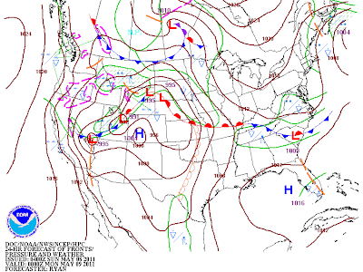
A strong capping inversion will be in place across much of the region today, which means that thunderstorm development won't likely occur until late afternoon and/or this evening, along and North of a surface warm front and East of a low pressure center over South Dakota & Nebraska, as shown by the surface forecast map below:
The activity will then spread East/Southeastward into adjacent portions of Iowa, Minnesota and northern Missouri later this evening & tonight.
In yesterday's outlook for today, the SPC outlined another, smaller, severe weather risk area for this afternoon, across southwest Oklahoma and into portions of West Texas, along and ahead of the surface dryline. The SPC has removed that risk area from today's outlook, fearing that the capping inversion in place across the region will prevent thunderstorms from being able to form.
I would say that there is a "conditional" risk of severe weather across the entire high plains region (see red outlined area on image below) ahead of the dryline this afternoon. "Conditional" means that if a thunderstorm is able to form along the dryline late this afternoon or evening, it will most certainly become severe. The question, and what makes the risk of severe weather "conditional", is whether or not a thunderstorm will manage to break the cap and develop in the first place.
Residents along the dryline from southwest Nebraska into portions of Western & central Kansas, western Oklahoma and into west Texas should keep a casual eye on the sky late this afternoon & evening. Check the weather and see if anything has managed to develop, and whether it will threaten your area...
A greater risk of severe weather is upcoming for the High Plains Wednesday. I'll make a separate post on that threat shortly...


No comments:
Post a Comment