Over the past 5-7 days, widespread rains of 2-5 inches, with locally higher amounts, have fallen across much of central and southwest Texas (click to enlarge; legend on right):
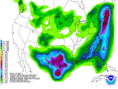
An upper-level low pressure system is moving toward Texas from the West and will spread additional heavy rains across much of the state during the period tonight (or early Thursday) through Saturday morning. Rainfall amounts of 2-4 inches will be common (purple areas on the image below), with localized amounts of 6 inches or more possible:
An upper-level low pressure system is moving toward Texas from the West and will spread additional heavy rains across much of the state during the period tonight (or early Thursday) through Saturday morning. Rainfall amounts of 2-4 inches will be common (purple areas on the image below), with localized amounts of 6 inches or more possible:
If you live in a flood prone or low-lying area, particularly one that has seen heavy rains already over the past few days, be on the alert tomorrow through Saturday for possible flooding.
If you are out driving across the Lone Star State over the next few days and come across water covering the roadway - remember to "Turn Around - Don't Drown!"
For more information, including "live blogging" during rapidly changing weather events, please be sure to follow me on facebook and/or twitter:


1 comment:
Live down here in Fayetteville, near La Grange, and I'll gladly take any flooding rainfall.
Post a Comment