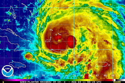
Over the past hour, infrared satellite imagery has begun to show an eye emerging once again on Irene (see latest image above).
An Air Force Hurricane Hunter aircraft is investigating the system at this moment. Thus far, they have located a minimum pressure of 28.61 inches of mercury and a maximum wind of 94 mph near the surface (just to the Southwest of the center).
More data is to come from the current recon mission, and all of this valuable data will be fed into overnight computer model programs.
See my detailed post earlier for more specifics on the current forecast track and potential impacts for the U.S. Eastern Seaboard.
If you enjoy reading 'The Original Weather Blog', please be sure to "like" our facebook page!

No comments:
Post a Comment