At 4pm CDT (5pm EDT), the center of Tropical Storm Irene was located near St. Croix, or about 120 miles East/Southeast of San Juan, Puerto Rico. Maximum sustained winds were estimated at 50 mph, and the minimum central pressure was 29.50 inches of mercury. Irene was moving toward the West/Northwest at about 17 mph.
You can clearly see the circulation around the center of Irene on the latest radar image from San Juan, Puerto Rico:
As you can see, showers and thunderstorms are rapidly overspreading Puerto Rico at this hour, and this trend will continue into tonight, along with an increase in East-Northeasterly winds initially at Tropical Storm force, but likely near hurricane force later tonight. In addition, 5-10 inches of rain is also likely in parts of Puerto Rico through tonight and early Monday.
Irene took a jog to the North since the last update, which will result in the center passing directly over or perhaps even just North of Puerto Rico overnight tonight and early Monday.
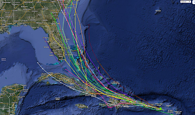
In the medium to longer-range timeframe, the computer model guidance continues to shift the track of Irene toward the "right". The latest computer model forecast composite image is shown below:
With the above as well as the recent movement of the system on satellite and radar imagery in mind, the official National Hurricane Center (NHC) forecast track (see image below) is quite a bit to the left of the model and observational consensus at this time:
I have a feeling that we'll continue to see the NHC shift the forecast track to the right based on recent observational and model trends. As I pointed out in a post earlier today, the ultimate key to predicting the amount of impact the system will have on Florida later this week hinges on when Irene will make a turn more toward the Northwest. At this time, the model consensus points to this taking place on Tuesday after the system passes over Haiti. I'd also like to point out that on this more Northerly track that has been observed today and is forecast by the models going forward, there may be less of a land impact than earlier expected, which could result in an even stronger hurricane ultimately affecting the U.S.
At this point in time, there is little doubt in my mind that Irene will have an impact on Florida late Thursday and into Friday - primarily for the Eastern part of the state as alluded to in my earlier post. The question is how much of an impact will she have on Florida? We should know the answer to this question more definitively by late Monday or Tuesday. In the meantime, I strongly urge residents of Florida, particularly along the Eastern coastline, to make preparations sooner rather than later.
In my post earlier today, I mentioned that in my mind, the likely track of Irene (with respect to Florida), looks remarkably similar to that of Hurricane Cleo from back in 1964:
This general theory continues to hold water (no pun intended) at this time. If anything, the Cleo track may end up being slightly to the left of where Irene ultimately travels, if the current observations and forecast model guidance pan out.
If the center of Irene remains offshore, even just immediately offshore, of Florida, then the system will likely grow even stronger as it approaches the Georgia/South Carolina border areas by early Saturday. This possibility is hinted at by the recent runs of the ECMWF model (image below valid 8am EDT Saturday, 8-27-11):
...as well as the latest GFS model forecast valid at the same time:
If the above model solutions verify, then we could be looking at a Category 3 or stronger storm impacting the region from Georgia to the Carolinas over the upcoming weekend. The last time a "major" (Category 3 or higher) hurricane impacted this area was in association with Hurricane Hugo back in 1989. Hugo ultimately ended up a Category 5 storm. I'm not saying that Irene will do the same, but she is likely to be at least Category 3 based on current projections.
What all of this means is that if you live anywhere along the Southeast U.S. coast, from Florida through Georgia and the Carolinas, you should begin preparing for Hurricane Irene now. Take the opportunity to review your preparedness plan and stock up on needed supplies now while they are plentiful, rather than waiting until closer to the time of potential impact when they are likely to be harder to come by.
Furthermore, this system could have significant impacts much further Northward along the Eastern seaboard into the following week (week of August 28th). This was alluded to in my post earlier today, and that forecast is still "on track" at this time. Below is the latest GFS computer model forecast valid 8am EDT Monday, August 29th. As you can see, the model is forecasting the system to be right on top of New York City at that time:
If the above computer model forecast verifies, some serious trouble with respect to both rain and wind can be expected in the "Big Cities" of the Northeast in roughly 1 weeks time. A lot can obviously change between now and then, but this should serve as fair warning to all folks along the Eastern seaboard to keep a close eye on the progress of Irene over the coming days.
If you enjoy reading 'The Original Weather Blog', please be sure to "like" our facebook page!


2 comments:
I've been watching Irene closely as I have family in Carolina Beach and Wilmington...business owners, to boot.
Keeping my fingers crossed that Irene doesn't live up to her potential!!!
Anthill Goddess, I hope they're making preparations. This looks to be a major event for that region by Saturday of this week...
Post a Comment