Above are the latest visible ("naked eye view"), infrared (measures the cloud temperatures) and water vapor (measures the moisture content) satellite images of Irene. As you can see, the eye of Irene is beginning to emerge once again on the infrared and especially on the water vapor imagery.
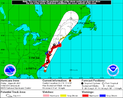
As of the 5pm EDT National Hurricane Center (NHC) Advisory, Hurricane Warnings were extended Northward as far as Sagamore Beach, MA. This means that a Hurricane Warning is now in effect for New York City, Long Island, Long Island Sound, Coastal Connecticut and Rhode Island, Martha's Vinyard and Nantucket. See the color coded NHC map below for a visual representation:
Irene is moving toward the North/Northeast at 14 mph, with a minimum central pressure of 28.05 inches of mercury (950 millibars) and maximum sustained winds of 100-105 mph (statistics as of the 8pm EDT NHC Advisory).
Both the satellite imagery and the latest Charleston, SC radar image (below) show that some of heaviest squalls yet are about to move onshore across the Carolinas:
For more detailed information on the likely impacts across North Carolina, please see my latest Hurricane Irene Impacts post here.
The center of Irene will move out over the Gulf Stream throughout the evening and overnight hours, which I believe will result in gradual intensification (note the recent drop in pressure compared to the observation 3 hours ago). As mentioned in the North Carolina-specific post referenced above, I expect Irene to have maximum sustained winds of at least 115 mph as she approaches the outer banks tomorrow. Some computer models forecast even higher sustained winds by that time. We will have to monitor trends this evening and overnight for additional updates.
Beyond North Carolina (again, for specifics on North Carolina, please go to this recent post), Irene is forecast to have significant impact all the way up the coast through the Baltimore/Washington area and into New York City, Long Island and New England over the weekend.
Based on the latest observations and computer forecast model guidance, here is how I see the primary wind threats panning out this weekend:
Another important thing to remember about the winds with Irene has to do with the duration of the event. The winds shown on the image above are the maximum expected sustained winds and wind gusts. Those maximum winds will take place for a period of 6-9 hours at any given location, based on the current expected movement of Irene. Less intense, but still strong, winds will take place for up to an additional 12 hours at any given location (i.e., tropical storm force winds that arrive well before the hurricane force winds, etc.). This will result in local areas being impacted with sustained 40+ mph winds and frequent gusts of 60+ mph for 18-24 hours total in some areas!
In addition to strong winds, very heavy, potentially flooding rainfall of 6-10 inches with localized amounts of 12-14 inches can be expected along the path of Irene. With grounds already saturated from recent rainfall, added to the heavy rains from Irene and the strong winds, this will create the potential for widespread tree damage, which will increase an already high threat of widespread power outages.
Most of the major metropolitan areas, including New York City, have announced that transit systems will be shut down beginning sometime Saturday. Now is the time to act. If you live in a flood or storm surge prone area (i.e., Evacuation Zones A and B in the New York City area), I strongly suggest that you consider moving West this evening or early Saturday to avoid Irene. There will be no public mode of transportation after tomorrow afternoon, and the roads are also likely to become grid-locked in some areas by that time as well...
The City of New York has declared a mandatory evacuation for Zone A.
Beyond the wind, rain and flooding impacts of Irene, storm surge will also be a significant problem in many areas. Depending on exactly when the center of Irene passes through a given location (in relation to high tide, etc.), significant amounts of water can be expected to be pushed inland, including in the New York city area (hence the cause for the evacuation call for Zone A in New York City - and, frankly, I don't like the chances for Zone B either).
Power outages will be widespread, and communications will also be severely disrupted in many areas. That's why we strongly encourage you to take action now before the storm gets any closer.
I will post additional region-specific updates as a more precise idea as to the specific impacts emerge.
If you enjoy reading 'The Original Weather Blog', please be sure to "like" our facebook page!


No comments:
Post a Comment