Above is the latest visible satellite image over the western Atlantic, with a yellow circle around Invest 96, the latest disturbance to pop-up to the South of the Yucatan peninsula. The same disturbance is circled on the corresponding infrared satellite image below:
So far this month we've had 2 systems make an attempt at being a tropical storm or hurricane and impact Florida (the unnamed storm that should have been named back on the 9th, and Invest 95 that affected the state earlier this week). Will Invest 96 on the above images break the trend, or will it be "3 strikes and you're out" for the sunshine state as far as October landfalling storms go?
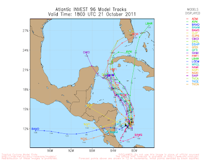
Below is the latest composite image showing the short to medium range computer models, which agree the system will track North/Northwestward and intensify:
In the medium to longer range, the GFS model shows the system as a Hurricane on the Western tip of Cuba at 8am EDT on Thursday, October 27th, as shown in the image below:
The ECMWF model agrees, with a nearly identical projection valid at the same time, as shown on the image below:
The ECMWF model goes on to show an impact along the Florida coast, to the South of Tampa Bay, by 8am EDT on Friday, October 28th:
The GFS model ultimately depicts a different solution for Florida, showing the system meandering around Western Cuba at the end of next week before being redirected Eastward ahead of a cold frontal boundary, as shown in the following image valid 8am EDT on Saturday, October 29th:
I think there is little question at this time that we will have a Tropical Storm or Hurricane near Western Cuba by Thursday of next week. The exact time of arrival of the surface cold front and upper-level trough to the region at the end of next week will determine whether the system moves Northward into Florida, or is picked up by the front and redirected to the South and East of the state.
Stay tuned, because this will be interesting either way!
If you enjoy reading 'The Original Weather Blog', please be sure to "like" our facebook page!


No comments:
Post a Comment