Showing posts with label Tropical Storm Lee. Show all posts

Monday, September 26, 2011

Another Casualty of Irene: The Northeast Pumpkin Crop...


According to this article (just one of many circulating today), the pumpkin crop across the Northeast U.S. took a big hit from Hurricane Irene, and the heavy rains that closely followed from Tropical Storm Lee:


If you live in the Northeast U.S. and want to get a decent pumpkin this year, you'd better buy early...and be prepared to spend more than usual!


If you enjoy reading 'The Original Weather Blog', please be sure to "like" our facebook page!

Tuesday, September 6, 2011

Tropics: Update on Katia; Maria and Nate Waiting In the Wings?


The above visible satellite image shows Hurricane Katia centered about 370 miles South of Bermuda, and moving toward the Northwest at 9 mph.  Maximum sustained winds were estimated 120 mph with a minimum barometric pressure of 28.17 inches of mercury (954 millibars).

All of the major computer forecast models during the last 24 hours have continued to come into consensus that Katia will turn out to sea late tomorrow and Thursday, before making a significant impact on the U.S.  The latest National Hurricane Center (NHC) forecast is below:


...which largely lies down the middle of the model consensus:


Katia is a large storm, and even though the center will pass well to the East of the U.S. Coast as currently forecast, increasing wave action and strong rip currents can be expected from the Carolinas on Northward beginning late tomorrow and continuing through at least Saturday (while spreading from South to North).

The images below are experimental wave forecast models that show the potential wave action along the Carolina and Virginia coasts by 11am EDT on Thursday the 8th:


...and off the New England coast by 11am EDT on Friday the 9th:


The bright green shaded areas just to the East of the immediate coastline depict the models estimate of 5-7 meter (16-23 foot) waves.  All of this increased wave action will also produce dangerous rip currents all along the adjacent portions of the Eastern seaboard toward the end of the week as well...

Something pretty drastic would have to take place in the atmosphere in order for Katia to veer West of the current forecast track.  The remnants of Lee along with a trough of low pressure across the Eastern U.S. toward the end of the week are both expected to result in the Northward (and eventual Northeastward) turn of Katia (see latest GFS computer model image valid 11am EDT Thursday, below).  We should start to see the beginning of that turn as early as tomorrow evening as the center of Katia approaches 70 degrees West Longitude, so keep an eye out for that...


Meanwhile, there are two other disturbances that bear close watching over the coming days....

The first is currently a little more than 600 miles West/Southwest of the southernmost Cape Verde Islands, and moving toward the West/Northwest:


I would expect this disturbance to be named a Depression later today, and the computer models generally carry the system toward the West/Northwest and then Northwest over the next 5 days:


The second area to watch is much closer to home, currently taking shape over the far southern Gulf of Mexico:


This system is still in the early development stage, however it bears watching over the next few days.  Some of the computer models eventually take it directly Southwest into Mexico, while others track it toward the Northeast across the Gulf toward the southeast U.S. over the weekend.

While it's way too early to tell what this system is going to do, I am afraid to say that folks in Texas (including yours truly) should not get their hopes up for rain out of this system, as a building area of high pressure to our West and Northwest later this week will likely steer the system away from us - regardless of the exact direction...


If you enjoy reading 'The Original Weather Blog', please be sure to "like" our facebook page!

Monday, September 5, 2011

Remnants of Lee Spread Torrential Rains to the East and Northeast...


The remnants of Tropical Storm Lee are spreading widespread, torrential rains East and Northeastward into the Southeast U.S. and Tennessee Valley states this morning.  The above radar mosaic was taken just a few moments ago, and shows the most intense rains currently centered over much of Alabama.

Widespread rains of 4-6 inches with local amounts of 8-10 inches are forecast across much of the Deep South and into portions of the Tennessee Valley and Appalachians today:


There is a high potential for flooding of rivers and streams as well as flash flooding of low lying and poor drainage areas in this region today.  The highest risk lies within the red hatched area on the image below:


The threat of heavy rain and flooding will continue spreading Northeastward on Tuesday, with widespread 2-4 inch and local 6 inch rainfall amounts forecast in the purple shaded areas on the image below: 


If you live in these areas, it's still not too late to plan ahead for this event.  Make sure that you have the necessary supplies on hand for your severe weather emergency kit, and have a plan of action ready in case waters begin to rise or evacuation orders are given for your area.

Isolated tornadoes are always a threat in association with tropical systems, even those in a diminishing state such as the remains of Lee.  There is still plenty of "spin" associated with the remains of the system, which under the right conditions can produce tornadoes.  The SPC in Norman, OK is forecasting a "moderate" risk of severe weather mainly due to the tornado threat in assocation with the remnants of Lee today.  That threat area is outlined in red on the image below:


This includes the Birmingham, Atlanta, Columbus and Dothan areas.  Tornado watches are currently in effect for this region as well:


If you enjoy reading 'The Original Weather Blog', please be sure to "like" our facebook page!

Sunday, September 4, 2011

Torrential Rains of Tropical Storm Lee to Spread Northeastward...


At 8:30 a.m. CDT, the center of Tropical Storm Lee was located just South/Southeast of the New Iberia airport in southcentral Louisiana. I've circled the center in red on the same radar image below just in case you can't make that out:


As shown on the graph below, the barometric pressure at the New Iberia airport has been dropping steadily...and now rests at 29.15 inches of mercury:


Rainfall has also been increasing at the same location (bottom half of the above chart).  The red bars show the hourly rainfall rates - currently approaching 1 inch at the airport.

Sustained winds of 35-45 mph, with gusts to 55 mph continue to be reported, mainly on the Eastern side of Lee.  The winds will steadily decrease now that the center of Lee is moving further inland, however gusts of 40-50 mph can be expected in stronger squalls through this morning.

As has been the case all along, the biggest story with Lee will continue to be torrential rainfall.  The image below is the Storm Total Rainfall Estimate from the doppler radar located near New Orleans:


The pink shaded areas show where the radar estimates an average of 7-8 inches of rain has fallen.  The lavender shaded areas average 8.0-9.5 inches, and the spotty white areas show where the radar is estimating 10-10.5 inches of rain - so far.  

Ever wonder just how accurate the radar rainfall estimation is?  Just to give an example, the highest 24 hour rainfall total that I could find on the airport observing stations (again for emphasis, airport observing stations - not all observing stations) was 7.17 inches at the Pascagoula airport in Mississippi (see table below):


I have noted the location of the airport on the same radar rainfall estimate image below, using a white arrow (look toward the right center portion of the image):


If you hover over the airport location, the radar estimates that 6.93 inches of rain has fallen there.  Pretty darn close to 7.17 if you ask me!  Now granted, I have not "quality controlled" the remainder of the above reports, but needless to say, the radar precipitation estimate is certainly giving us a good idea as to what is actually happening on the ground.

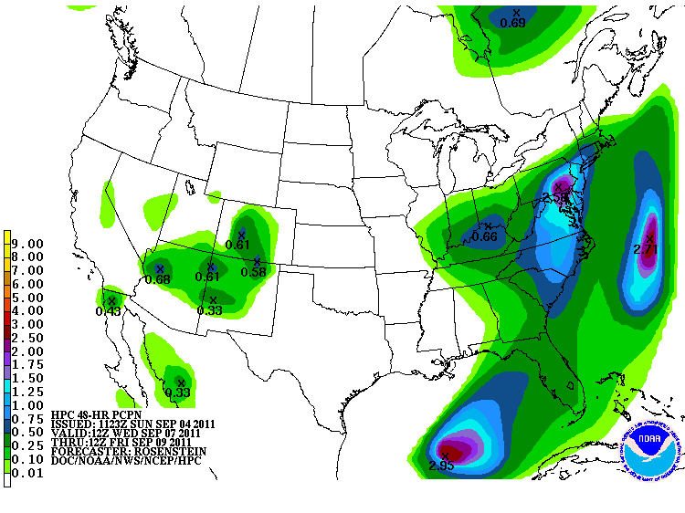
Torrential rains will continue spreading slowly Northeastward today, then more rapidly tonight and into early next week.  Below is the latest total precipitation forecast for today, Monday and Tuesday:


As you can see, widespread amounts of 6-8 inches, with localized amounts near 10 inches are forecast across a large part of the southeast and into the Tennessee Valley, Appalachians and mid-Atlantic region.  This will be falling on top of already rain soaked grounds from Irene in many areas, which will lead to an even greater threat of flash flooding and river/stream flooding.

Here is how the rainfall forecast is broken down by day, starting with today:


...and Labor Day Monday:


...and Tuesday:


As you can see, the greatest potential impact to areas affected by Irene last week will take place beginning Tuesday.  By the period Wednesday through Friday, heavy rains are forecast to advance up into New England as well:


With many rivers still in flood across the region after Irene, it is critical that folks from the Mid-Atlantic on Northward pay very close attention to later forecasts involving the latest round of heavy rains from Lee.  Meanwhile, folks back to the South will continue dealing with heavy, potentially flooding rains from Lee today through Labor Day.

Isolated tornadoes will also continue to be a threat with Lee today, particularly in association with stronger squalls to the "right" (East) of the center.   The SPC has issued a Tornado Watch for much of this region valid until 4pm CDT today:


If you enjoy reading 'The Original Weather Blog', please be sure to "like" our facebook page!

Saturday, September 3, 2011

Center of Lee Appears to Be Making Landfall


After wobbling along the coast for most of the day, the radar image above seems to indicate that the center of Tropical Storm Lee is about to make landfall just North of the Vermillion Oil Platform along the Louisiana coast.  

The latest observation from the platform shows a barometric pressure reading of 28.95 inches of mercury, as shown on the graph below:


As I pointed out in a more detailed post earlier today, the location of the center of Lee is really not that significant (other than for obtaining the minimum pressure reading) as strong, gusty winds and very heavy rain extend well out in all directions from the center.

While we're talking about the center, you may have noticed the small red dot on the above radar image.  I've circled it in red on the same image below just in case you can't see it:


That was the location of the center of Lee at about 8:30 a.m. CDT this morning.  As you can see, the center is actually making landfall some 30-35 miles West/Northwest of that location at this time (as noted by the small red "x" along the coast to the North of the Vermillion oil platform).  That illustrates what I mean by saying that Lee has been "wobbling" along the coast today.  The actual movement of the center has been erratic at times.


If you enjoy reading 'The Original Weather Blog', please be sure to "like" our facebook page!

Tropical Storm Lee Hammering Louisiana...


The center of Tropical Storm Lee is immediately offshore of the Louisiana coast this morning. As of the 7am CDT National Hurricane Center Advisory the center was located about 15 miles South/Southeast of Intracoastal City, Louisiana, which was about 45 miles south of New Iberia, Louisiana, and moving North/Northwest at 5-7 mph.  Based on radar over the last 90 minutes, that trend has remain largely unchanged as Lee is currently wobbling to the West/Northwest or Northwest very slowly.

Maximum sustained winds are estimated by radar near 60 mph.  I found a buoy located offshore near East Cameron with a sustained wind of 43 mph, gusting to 58 mph:


Another buoy, located at South Marsh and operated by Apache Corp. is currently registering the minimum central pressure of Lee, at 29.35 inches of mercury (995 millibars):


Visible satellite imagery shows that Lee has become quite organized early this morning, especially for a system that's been at least partially over land for nearly 24 hours:


Lee is expected to continue wobbling around the coast for the next couple of hours, with the center possibly making landfall by mid-morning.  A couple of the models even show the center crossing land, then crossing back out over the water by midday before making a permanent landfall this afternoon.  The latest NHC forecast track image is below:


The main thing to focus on with Lee is not the location of the center, as the affects via rain and wind are widespread and placed well beyond the center core of the system.

Tropical storm force winds, and especially gusts, can be expected across much of the Southeast half of Louisiana today.  Similar conditions are likely to spread into at least southern Mississippi by this afternoon and evening:


The strong gusty winds and saturated grounds will make it that much easier for trees to be toppled in this region today, which will lead to an increased threat of power outages.  I strongly suggest having a NOAA Weather Radio with battery back-up on hand in case this happens in your area, that way you can keep up with the latest information.  If you live a bit further North along the projected path of Lee where heavier rains and stronger winds have not yet developed, you still have time this morning to go out and get those and other needed supplies for your severe weather emergency kit.

While strong, gusty winds and the associated hazards can be expected across the region today, the biggest story and most significant threat from Lee will continue to come in the form of very heavy, potentially flooding rainfall.  The image below shows the radar's estimate of total rainfall so far from Lee, with some of the heavier cores noted:


The darker red shaded areas which cover much of the image show rainfall estimates of 4 inches or greater, and keep in mind that rain continues to fall at a steady rate.  The heavier 6-8 inch rains that I've noted with the arrows are working their way to adjacent onshore areas as rain continues to fall across the region.

The images below show the latest rainfall forecasts for Lee, valid today, Sunday and Monday, in that order:


As you can see, by Monday, heavy rains are forecast to spread Northeast into the Mid-Atlantic, including some of the areas that were hard hit by heavy rain from Irene.  The 3 day forecast of total rainfall for today through Monday is shown on the image below:

If you live in a flood prone area along or near the path of Lee, please take immediate precautions to move to higher ground before flooding develops.  Rains of this strength and duration can easily lead to washed out bridges and/or roads, which may make escape more difficult later on.  Please check statements from your local NWS office for any voluntary or mandatory evacuation orders that may be in effect for your area.

Isolated tornadoes will also be possible along and especially to the "right" of the center of Lee, and a Tornado Watch is currently in effect for much of that region (I expect the valid time to be extended beyond 10am, and the watch area may also be shifted slightly Northward by that time as well):


If you enjoy reading 'The Original Weather Blog', please be sure to "like" our facebook page!


Friday, September 2, 2011

We Now Have Tropical Storm "Lee" In the Gulf...


Tropical Storm Lee has now formed in the Gulf. At 4pm CDT, the center of Lee was located 220 miles Southeast of Port Arthur, TX and drifting Northward at 2 mph.  Maximum sustained winds were 45 mph and the minimum barometric pressure was 29.62 inches of mercury (1003 millibars).

As I mentioned yesterday and earlier this morning, the main threat with Lee will be torrential, flooding rains.  He is forecast to meander generally Northward over the next few days, before moving inland over southeast Louisiana on Sunday.


Widespread rains of 10-15 inches with local amounts near 20 inches can be expected along and near the immediate path of Lee through Sunday.  Heavier rains will spread Northeastward into parts of the Southeast and Mid-Atlantic by the first of next week.  The rainfall forecast below is valid 7pm CDT today through 7pm CDT Monday:


Unfortunately, as we indicated yesterday, the expected track of Lee will not bring any major relief (in the form of rain) to the drought in Texas.  Cooler air will still flow into the region by Labor Day, but rainfall ahead of the cold front will be sparse compared to the widespread rains associated with Lee.


If you enjoy reading 'The Original Weather Blog', please be sure to "like" our facebook page!