The center of Tropical Storm Lee is immediately offshore of the Louisiana coast this morning. As of the 7am CDT National Hurricane Center Advisory the center was located about 15 miles South/Southeast of Intracoastal City, Louisiana, which was about 45 miles south of New Iberia, Louisiana, and moving North/Northwest at 5-7 mph. Based on radar over the last 90 minutes, that trend has remain largely unchanged as Lee is currently wobbling to the West/Northwest or Northwest very slowly.
Maximum sustained winds are estimated by radar near 60 mph. I found a buoy located offshore near East Cameron with a sustained wind of 43 mph, gusting to 58 mph:
Another buoy, located at South Marsh and operated by Apache Corp. is currently registering the minimum central pressure of Lee, at 29.35 inches of mercury (995 millibars):
Visible satellite imagery shows that Lee has become quite organized early this morning, especially for a system that's been at least partially over land for nearly 24 hours:
Lee is expected to continue wobbling around the coast for the next couple of hours, with the center possibly making landfall by mid-morning. A couple of the models even show the center crossing land, then crossing back out over the water by midday before making a permanent landfall this afternoon. The latest NHC forecast track image is below:
The main thing to focus on with Lee is not the location of the center, as the affects via rain and wind are widespread and placed well beyond the center core of the system.
Tropical storm force winds, and especially gusts, can be expected across much of the Southeast half of Louisiana today. Similar conditions are likely to spread into at least southern Mississippi by this afternoon and evening:
The strong gusty winds and saturated grounds will make it that much easier for trees to be toppled in this region today, which will lead to an increased threat of power outages. I strongly suggest having a NOAA Weather Radio with battery back-up on hand in case this happens in your area, that way you can keep up with the latest information. If you live a bit further North along the projected path of Lee where heavier rains and stronger winds have not yet developed, you still have time this morning to go out and get those and other needed supplies for your severe weather emergency kit.
While strong, gusty winds and the associated hazards can be expected across the region today, the biggest story and most significant threat from Lee will continue to come in the form of very heavy, potentially flooding rainfall. The image below shows the radar's estimate of total rainfall so far from Lee, with some of the heavier cores noted:
The darker red shaded areas which cover much of the image show rainfall estimates of 4 inches or greater, and keep in mind that rain continues to fall at a steady rate. The heavier 6-8 inch rains that I've noted with the arrows are working their way to adjacent onshore areas as rain continues to fall across the region.
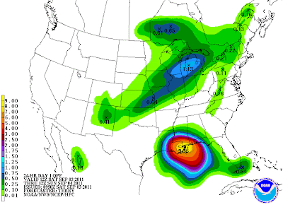
The images below show the latest rainfall forecasts for Lee, valid today, Sunday and Monday, in that order:
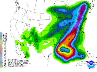
As you can see, by Monday, heavy rains are forecast to spread Northeast into the Mid-Atlantic, including some of the areas that were hard hit by heavy rain from Irene. The 3 day forecast of total rainfall for today through Monday is shown on the image below:
If you live in a flood prone area along or near the path of Lee, please take immediate precautions to move to higher ground before flooding develops. Rains of this strength and duration can easily lead to washed out bridges and/or roads, which may make escape more difficult later on. Please check statements from your local NWS office for any voluntary or mandatory evacuation orders that may be in effect for your area.
Isolated tornadoes will also be possible along and especially to the "right" of the center of Lee, and a Tornado Watch is currently in effect for much of that region (I expect the valid time to be extended beyond 10am, and the watch area may also be shifted slightly Northward by that time as well):
If you enjoy reading 'The Original Weather Blog', please be sure to "like" our facebook page!


7 comments:
Rob-I'm really scared. Lee is coming straight for us :( I have no idea if we are prone to flooding here...They are saying the forecast track isn't concrete-a lot can change between now and Monday. Is this true?
Shamrock, I'd be ready for a lot of rain. Right now looks like you could get 4-7" plus. If you don't have any streams near you I wouldn't be too concerned about river flooding, but some flash flooding in poor drainage areas would certainly be a possibility in such an event.
The exact rainfall prospects for you will become more clear by tomorrow.
Wish we could get that down here in Texas - we'd take every single drop, even if it meant some stream flooding in some areas before it was over with (which seems hard to imagine the way things are right now)!
I am mostly worried about tornados.
Also, we are next to a creek..
Shamrock, I wouldn't be too worried about tornadoes. The way things look right now it looks like a 4-6 inch rain event for you guys, probably spread out over a period of time enough that you wouldn't have as great of a flash flood threat as folks further to your East and South will have to deal with...
Good...no tornados. One was enough for me this year. I don't want tornados for anyone actually....I don't want flooding for anyone either. Thanks for the update, Rob. The NWS and the media give conflicting reports. You are straight and to the point. Thanks again!
I learn some new stuff from it too, thanks for sharing your information. Louisiana
Post a Comment