Tuesday, March 29, 2011


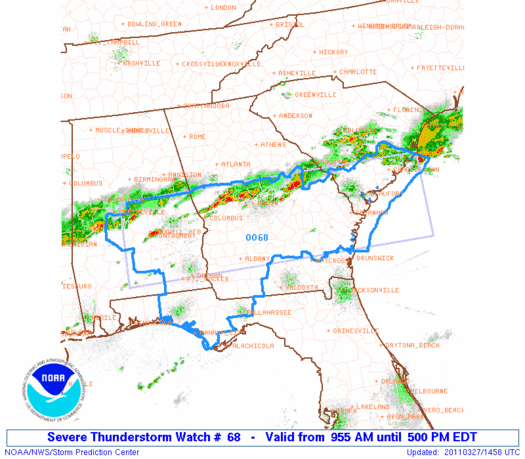
Severe Thunderstorm Watch Until 11pm

A Severe Thunderstorm Watch was just issued for much of southcentral Texas and the coastal bend, valid until 11pm CDT this evening. This watch includes the Austin/San Antonio corridor, as well as Corpus Christi and Del Rio.
Thunderstorms are currently developing West of the Rio Grande in Mexico and are moving Eastward. Additional thunderstorm development is expected later this afternoon and evening along and ahead of a cold front that is currently moving into the far Northwest portion of the watch area.
Severe Storms Possible Along With Much Needed Rains in TX

The above image shows the latest severe weather outlook for today from the SPC. Severe storms are forecast within the area outlined in green.
As noted yesterday, a cold front will be sagging Southward across Texas during the day today. As the atmosphere heats and destabilizes, at least isolated thunderstorms are expected to form along and ahead of the southcentral Texas portion of the boundary this afternoon and evening. A more solid line of storms is likely along the eastcentral Texas and Louisiana portions of the front, where the atmosphere will be more conducive to widespread development.
The only limiting factor over southcentral Texas is a layer of warm air above ground level (also known as a "cap") which will tend to limit widespread thunderstorm development. However, any thunderstorms that do form are likely to become severe, with large hail likely:

Much needed rain will also fall across the areas that do see thunderstorm development. Below is the latest rainfall forecast for today from the HPC:

Monday, March 28, 2011
Much Needed Rain Still Appears Likely - Question is: How Much???
In a post late last week, I remarked that it appeared as though some much needed rain was on the way for much of Texas this week. That still appears to be the case, as a frontal boundary combines with an upper level weather disturbance and returning low-level moisture from the Gulf late Tuesday into at least the first half of Wednesday.
Below is the latest surface weather forecast from the HPC, valid 7pm CDT on Tuesday evening:


Below is the latest surface weather forecast from the HPC, valid 7pm CDT on Tuesday evening:

and 7am CDT on Wednesday morning:

The HPC is forecasting fairly widespread rain event across the central and eastern two-thirds of the state, as indicated on the rainfall forecast image below:

The $64,000 question is just how quickly the low-levels of the atmosphere will dry out behind the frontal boundary - and how quickly the upper-level energy will leave the state on Wednesday. Some computer forecast models want to retain some moisture and energy over the region into much of Wednesday (which would mean more rain), while others rapidly move the system out to the East (which would mean less rain).
The HPC rainfall forecast above tends to side more with the "rapidly moving out" scenario, which results in less overall rainfall. I am personally hoping for the "stalling out" scenario, as much more beneficial rains would fall across the region as a result. We'll have to see how things pan out over the next 24-36 hours.
Isolated strong to severe thunderstorms are also possible along and ahead of the front late Tuesday afternoon and evening (area outlined in green), as per the latest severe weather outlook from the SPC, below:

Sunday, March 27, 2011
Tornadic Supercell Over SW Georgia

An isolated tornadic supercell has formed over extreme Southwest Georgia. The above image was taken by the Tallahassee, FL radar a few moments ago (click to enlarge).
The left half of the image shows the radar reflectivity (i.e., rain, hail, etc.) while the right half of the image shows the velocity (i.e., wind motion toward and away from the radar).
The radar site is located just off the bottom right corner of the image. With that in mind, note the strong rotation on the velocity side of the image between Colquitt and Newton (remember, red shows wind blowing away from the radar, while green shows wind blowing toward the radar). This also corresponds to the strong, "hook echo" signature on the reflectivity side of the image.
The pinkish-purplish polygon shows where a Tornado Warning is currently in effect.
Active Severe Weather Day Yesterday - Round 2 Today

The above image shows severe weather reports (tornado reports highlighted in the text box on the left side of the image) from yesterday. As you can see, it was a very active day (as promised) across the Deep South.
It appears as though the region is in for another active weather day today, with severe storms already underway across portions of Alabama and Georgia at this time:
The SPC is forecasting severe storms to initiate across much of the same areas that were affected yesterday, then spread southward over time:

Initially, large hail and damaging winds will be the greatest threats, however as heating and instability increase this afternoon, isolated tornadoes will be possible once again.
Another threat today will be flash flooding. Since many of the same areas battered with heavy rain and thunderstorms repeatedly yesterday will be affected again today, the threat for flooding will be high in many areas.

The above image shows storm total rainfall (thus far) across much of Georgia. The darker red shaded areas indicate rainfall amounts of 3-4 inches, as estimated by the radar. Additional heavy rainfall can be expected in many of the same areas today, shifting Southward with time.
Saturday, March 26, 2011
A Pair of Supercells Over Southwest Georgia...

...both with impressive hook echoes. Moving East to East/Southeast at 30-35 mph. Tornado Warnings are in effect.
Below are the Base Velocity and Storm Relative Velocity images, respectively, of the same storms:


The pinkish-purplish polygons are Tornado Warning areas. Remember, in the velocity (wind motion) images, greens are winds moving toward the radar, reds are winds blowing away from the radar. The radar is located off to the bottom left corner of the image.
Deep South Severe Weather Update...

The above visible satellite image, taken at approximately 11:15 am CDT, shows cumulus clouds building and increasing across east-central Mississippi and extreme west-central Alabama. The atmosphere in this region is destabilizing fairly rapidly for this time of day, and thunderstorms are already beginning to break-out on the southern end of this area, as per the latest radar image below:

Thunderstorms are likely to continue to develop, organize and intensify over the next several hours and spread across adjacent portions of Alabama and eventually western Georgia. Large hail, damaging winds and tornadoes are likely with mature severe storms in this area. A few strong tornadoes are possible in association with the most severe storms.
I would expect the SPC to issue a Tornado Watch for much of this region within the next hour.
Groundhog's Day "Bust"
I think we can now safely declare that 'Punxsutawney Phil', the lovable "weather forecaster" with rodent-like tendencies, has officially busted his 2011 forecast that winter would "end early."
You may remember that back on Groundhog's Day, Phil didn't see his shadow. The legend of groundhog's day says that if the rodent - uh, er, I mean Phil - doesn't see his shadow then spring is right around the corner...
Well, Mother Nature has decided to one-up the rodent, with a few more rounds of wintry weather instore for much of the nation...
Below is the latest computer model forecast depiction of snow accumulation for the first half of this coming week, which includes a 6+ inch event in the Plains and Midwest:

...and to top it off, the latest hazard outlook for the end of March from the CPC includes a major cold snap for much of the Northern Plains and Midwest to round-out the month:

Too bad, Phil, can't win 'em all, I guess... better luck next year!
Deep South Severe Weather Update

The SPC will upgrade portions of Mississippi and Alabama into an enhanced severe weather & tornado risk area on the updated severe weather outlook to be issued at 11:30 am CDT. The "moderate risk" area will approximately correspond to the area outlined in red in the above image.
Severe Weather In Deep South Today

The above image shows the latest severe weather outlook for today and tonight, from the SPC. Severe thunderstorms are forecast within the green outlined region. The highest threat of severe storms, including tornadoes, will fall within the area outlined in red (and with the light blue hatch marks) in the "probability" image below:

A stationary front stretches across the region early this morning, and is expected to move little today (see latest HPC surface weather map and forecast image below):

Thunderstorms have already developed early this morning along and North of the boundary across portions of northern and eastern Arkansas, western Tennessee and adjacent portions of Mississippi and Alabama.

Marginally severe hail is possible with some of the stronger storms this morning. The main threat will come this afternoon and evening as the atmosphere along and South of the boundary heats and destabilizes. Large hail, damaging winds and isolated tornadoes will be possible with this activity.
Thursday, March 24, 2011
Wet Weather Finally on the Way?
I've been waiting a few days to make this post, making sure that computer forecast model runs remained consistent. They have become increasingly consistent over the past few days, with all major models now signaling a much wetter pattern for the Lone Star State for the 2nd half of next week.
This is very good news indeed, as wildfire danger has been running rampant across the state for much of the past 2 weeks. Many areas have also already implemented water rationing, with the hot summer months still weeks away.
Below is the latest GFS computer model forecast image valid at 7pm CST on Thursday, March 31st:

It shows a strong upper level weather disturbance digging southeast across Mexico, with widespread precipitation indicated well ahead of the feature across Texas.
I'll make more specific posts as the event nears, but right now it appears that rain will start overspreading the state from West to East beginning Wednesday. Stay tuned for details!
Tuesday, March 22, 2011
Severe Weather Update
Severe thunderstorms are underway across portions of the central Plains & Midwest. Below is an image showing a Tornado Watch (overlaying the latest radar image). The watch is in effect until 9pm CDT:

Thunderstorms are expected to continue to develop and intensify in and close to the watch area throughout the evening. Tornado warnings are in effect for most of the cells in southwest Iowa. Below is the latest radar image from the Des Moines area radar site. The pinkish-purplish polygons show areas that are under a tornado warning currently:

Meanwhile, further South in Oklahoma, an isolated thunderstorm is developing East of the dryline in Lincoln County. Below is the latest radar image from the Norman area doppler radar:

Additional development is possible in central and eastern Oklahoma this evening, ahead of the dryline (which is depicted by the thick blue line running NNE-SSW across the middle of the above radar image). Any thunderstorm that is able to develop and mature will likely become severe.
Severe Storms Across the Plains & Midwest Today

The above image is the latest surface weather forecast for today, as prepared by the HPC. Severe thunderstorms are expected to develop across portions of the central Plains and Midwest, as indicated by the green outlined region on latest SPC severe weather outlook below:

At this time it appears that the most significant threat of severe weather, including tornadoes, will take place in a region from extreme southeast Nebraska into southwest and southcentral Iowa and extreme Northwest Missouri, as indicated by the darker brown outlined area in the image below:

Severe storms are expected to develop late this afternoon across southcentral Nebraska and northcentral Kansas, and move or develop East/Northeast over time. Large hail, damaging winds and tornadoes will be possible with this activity.
Other, more isolated, thunderstorms are expected to develop southward along the dryline across central and eastern Kansas and extreme northcentral & northeast Oklahoma. Although more isolated, any storm that forms in this latter region will likely be severe with large hail, damaging winds and isolated tornadoes.
Thursday, March 17, 2011
Spring Break...
I apologize for the lack of posts recently, but it's spring break around here and we're trying to get in as much family time as possible.
I'm reading a book by Kevin M. Simmons and Daniel Sutter, entitled "Economic and Societal Impacts of Tornadoes". I hope to put up a review within the next few days.
We're also hoping to catch the IMAX release of 'Tornado Alley' and will be sure to post comments on that as well...
The weather has been relatively quiet across the nation this week, at least insofar as severe weather is concerned. Changes appear to be in the offing for at least the first part of next week. The latest Day 4-8 severe weather outlook from the SPC gives us a hint at what's to come:

I'm reading a book by Kevin M. Simmons and Daniel Sutter, entitled "Economic and Societal Impacts of Tornadoes". I hope to put up a review within the next few days.
We're also hoping to catch the IMAX release of 'Tornado Alley' and will be sure to post comments on that as well...

The above forecast is valid Monday, March 21st, and shows a potential severe weather threat area as shown within the purple outlined region over the high plains. Stay tuned for more....
Tuesday, March 15, 2011
Northerly Winds Bode Ill for Tokyo?

The above surface weather map of Asia shows that an area of low pressure has formed offshore to the East of the island of Japan overnight. Tokyo is roughly located at the tip of the red arrow, and the damaged Fukushima nuclear reactor site is roughly located at the tip of the purple arrow.
Winds blow in a counter-clockwise direction around an area of low pressure (in the Northern Hemisphere anyway). This means that a Northwesterly to Northerly wind will be in place over the Tokyo region for the next 12 hours or so (see the latest forecast for Tokyo here). Unfortunately, this could lead to higher levels of radation entering the city from the damaged reactor to the North.
Officials are working diligently to try and contain/stop the leak, but as you can imagine this is a very delicate operation.
Our thoughts & prayers certainly remain with the people suffering in Japan, and with those who are risking their lives to contain the reactor leak.
Friday, March 11, 2011
Oklahoma / North Texas Wildfires on Satellite Imagery
**Note: This post was originally made on 3-11-11 regarding wildfires in Oklahoma and Texas. If you are looking for my post concerning the Texas wildfires of Labor Day Weekend 2011, please go to this link to see that post...
-------------------------------Original Post Continues Below:

Not to sound like a bad game of "Where's Waldo", but can you spot the largest fires burning in the above visible satellite image?
You can pull and view visible satellite imagery from hundreds of different sources on the internet, but the above image (taken shortly after 4:30 pm CST) came from the COD Weatherlab site.
It's easier to spot the smoke plumes by viewing a loop of the imagery (once at the link site, click "visible satellite animation" in the upper right corner of the page).
The easiest way to distinguish clouds from the smoke plumes is that the clouds are moving Southeast, while the smoke plumes are flowing North-Northeast from the fire origin sites. Here are the ones that I found:

There are countless others burning, some are just not producing enough smoke to be detected as easily just yet.
The Governor of Oklahoma has declared a State of Emergency due to the wildfires raging across the state.
Wildfire danger will remain high on Saturday. The areas in the pink shaded regions below are under a "Red Flag Warning" again for Saturday:

Don't Forget to Spring Forward on Sunday...

Don't forget to turn your clocks forward at 2am CST, which will become 3am CDT, this Sunday morning. (Or you can take the lazy approach and adjust your clocks before you go to bed Saturday night).
I always dread this one... I hate losing that extra hour on Sunday!
Update on Wildfire Danger Today

The "critical" area for wildfire danger has been expanded since yesterday's post, and now includes most of West Texas and the panhandle, as well as western Oklahoma and east-central New Mexico.
Red Flag Warnings have been issued for a large part of the southern Plains today, as shown by the pink shaded areas on the map below:

Gusty Southerly winds and very low humidity will create extremely dangerous conditions today, where rangeland and other grass fires would quickly grow out of control.
Tsunami to Affect Parts of U.S. After Massive Japanese Quake
As I'm sure you've heard by now, a massive earthquake struck off the coast of Japan about 11:45 PM U.S. Central time last night (about 2:45 in the afternoon Tokyo time). The initial quake measured 8.9 on the Richter Scale, and there have been numerous aftershocks ranging from 5.0 to 6.5 since the original quake.

The original quake, at magnitude 8.9, was the 5th largest to strike anywhere in the world since 1900.
Casualties and damage are widespread across Japan, and our thoughts and prayers certainly go out to folks in that part of the world.
A large wave (also called a Tsunami) has been generated by the series of quakes, and a Tsunami Warning is in effect for all of Hawaii. Many parts of the outer shores of the islands have been evacuated, and coastal residents are encouraged to seek higher ground.
Higher wave action may also be felt as far East as the northern portions of the California coast and the Oregon coast today, but more on the order of 6 feet or so above normal. Crescent City, California would probably be in the center of the highest wave action, according to the California Department of Emergency Management.
You can follow a live feed from the BBC on the aftermath of the quake, as well as news on the ongoing Tsunami threats, here.
Thursday, March 10, 2011
Extreme Fire Danger Out West Tomorrow

Extreme fire danger will exist across much of western and central Texas, western and central Oklahoma and central and eastern New Mexico on Friday. The area outlined in red on the map above will experience the highest danger, which has been termed "critical" by the NWS.
Ground conditions across the region are extremely dry, due to a lack of significant moisture for much of the winter and first of this year:

Very (to extremely) low humidity, bone dry grasses and vegetation and gusty South-Southwest winds will create the perfect environment for rapidly spreading wildfires across the region on Friday.
All residents should avoid burning (it has been banned in most areas anyway) and promptly report even a small fire to authorities before it has a chance to get out of hand (which can be very rapidly in this type of situation).
Tuesday, March 8, 2011
Confirmed Tornado Near Clarksville, TX

The above radar image was taken from the Shreveport, LA radar a few moments ago. It shows a line of intense thunderstorms extending from extreme southeast Oklahoma to near the Dallas area. The pink colored polygons show Tornado Warnings that are currently in effect.
At about 5:30 PM CST, a tornado was reported 2 miles North of Clarksville. Several homes reportedly have roof damage, a semi tractor-trailer was flipped over onto another vehicle, and numerous mobile homes have sustained damage, according to the report.
Below are some damage videos taken from YouTube. If you look closely at about 9 seconds into the second video, you can see what appears to be a tornadic circulation embedded in rain:
The image below was captured by Jim Bishop:

This storm had excellent warnings for over an hour before the tornado struck, so hopefully residents were seeking shelter. No injuries have yet been reported - a trend that hopefully will continue.
Unfortunately, this storm is in what I call a radar "no mans land". While you can see the reflectivity (rain, hail, etc.) just fine in the radar image at the top of the post, the storm is located 95 or more miles away from any particular radar site (i.e,. Shreveport, Ft. Worth, Ft. Smith), which means the radar beam is shooting into the storm at an elevation of about 10,000 feet above ground level. This doesn't give you a very good idea as to the low-level (i.e,. near ground level) rotation when looking at the wind motion mode of the radar (see illustration below).

Due to Earth's curvature, radar beam shoots increasingly higher into a
storm as it gets further away from the radar site.
Situations like this prove that a ground-based storm spotter program is still critical, even in this highly technical age.
Subscribe to:
Posts (Atom)