Wednesday, November 30, 2011

Update on Late Week / Weekend Winter Storm in Rockies / Plains...

As mentioned in a brief post yesterday evening, the latest model trends had shifted to a more Northerly track with respect to the most likely areas to be impacted by the approaching winter storm.  This trend has continued during the day today, with a continued focus on an area from northcentral and northeast New Mexico into southcentral and southeast Colorado, western and northern Kansas, roughly the southeast half of Nebraska and on into the northwest half of Iowa.


Here is the set-up as the situation is unfolding currently...


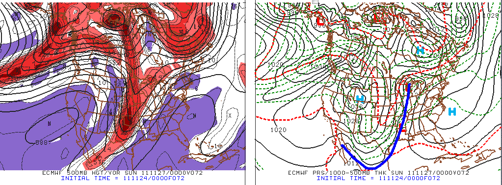
The latest water vapor satellite image shows an area of disturbed weather taking shape in the middle and upper-atmosphere over the southwest (red circled area on the image below):


This area of developing low pressure is forecast to spin around the southwest for the next 24-48 hours, while ejecting pieces of energy out to the Northeast across the central and southern Rockies.  

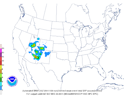
Snow will increase across this region tonight and Thursday, with locally heavy accumulation indicated by the yellow and orange shaded areas on the image below valid 6pm CST on Thursday evening (scale in inches on the bottom left side of the image):


As the trough of low pressure digs Southward across the southwest on Thursday and Friday, increasing amounts of energy will spread out to the East across the southern Rockies, resulting in heavier snowfall southward into New Mexico and Arizona, as indicated on the image below, valid 6pm CST on Friday evening:


Snow is forecast to increase in intensity across northeast New Mexico and the adjacent Plains Friday night and early Saturday.  The images below are valid 3am CST and 6am CST on Saturday morning, respectively:


As you can see, locally heavier snows will begin to spread Northeastward into portions of western Kansas, eastern Colorado and southwest Nebraska by dawn on Saturday morning.  By Saturday afternoon, this trend will continue Northeastward into the northwestern half of Iowa, as shown by the forecast images valid at 1pm and 4pm CST, respectively:


Strong and gusty North-Northeast winds of 20-30 mph with gusts over 40 mph will create blowing and drifting snow in some areas of the Plains in association with this system.  Winter Storm Watches and/or Warnings are already in effect for much of the central and southern Rockies, and I would expect to see these issued out Eastward into the Plains by tomorrow.

Meanwhile in the warm sector of the storm system, widespread rains will fall, with 1-2 inches indicated across portions of west-central Texas, and in an even larger area extending from east-central Texas across the mid-Mississippi Valley region.  Most of the rain on the image below will fall during the period Friday through Sunday:


Cold air will spill Southward across the Plains in association with a strong surface cold front, with temperatures forecast to reach 15-20 degrees below normal levels across much of Texas by 1pm CST Sunday:


Once in place, the cold air is likely to remain entrenched across much of the nation, as indicated on the 8-day temperature average (departure from normal) image shown below:


Folks across the indicated areas of the southern and central Rockies into the central and southern Plains should "stay tuned" for later updates as this weather situation continues to unfold...


If you enjoy reading 'The Original Weather Blog', please be sure to "like" our facebook page!

Tuesday, November 29, 2011

Weekend Winter Storm In the Making for the Plains...

In a "teaser" post yesterday evening, I showed the following image, depicting the GFS computer model forecast of snow accumulation across the central and southern Plains by 12 Midnight CST this Saturday night / Sunday morning:


Fast forward to today at about the same time, and here is what the latest run of the same computer forecast model shows for the same valid time of 12 Midnight CST on Saturday night / Sunday morning:


As you can see, the model has shifted the snow band Northward, now running from northeast New Mexico across Kansas instead of across the Texas Panhandle and northern Oklahoma.


At this time, there is still considerable uncertainty as to exactly where the rain vs. snow line is likely to set-up this weekend, but the model consensus has clearly shifted Northward over the last 24 hours.  If this trend holds through tonight and early tomorrow's computer model runs, we'll be able to speak much more confidently as to what is likely to take place - so stay tuned for a more detailed update (including regional impact maps) tomorrow.  


Until we are able to speak with greater certainty on this event, folks all across the region from eastern New Mexico across the Texas and Oklahoma Panhandles, Kansas and northern Oklahoma should monitor the development and progression of this system and stay tuned for later updates...


Meanwhile, colder than normal weather still appears likely for much of the lower 48 United States through most of next week, as shown by the latest GFS computer model temperature anomaly forecast below (blue and green shaded areas indicate below normal temperatures):


If you enjoy reading 'The Original Weather Blog', please be sure to "like" our facebook page!

A Look At Yesterday Evening's Snow in the Deep South...


The image above shows snow depth as estimated by satellite imagery and computer models across the middle and lower Mississippi River Valley region at 6am CST this morning.   This particular image is from the Interactive Snow Information site via NOAA.  Below is a slightly different (geographically speaking) representation via NOAA's National Snow Analysis Center:


As you can see on both of the images, there are 2 patches of heavier snow depth indicated (on the order of 4-8 inches):  the first over extreme northeastern Arkansas, and the second over southeastern Missouri.  In fact, storm reports indicate 8.0 inches of snow fell near Paragould and 6 inches of snow fell near Jonesboro, both in Arkansas.  A report of 4.5 inches of snow came in from Caruthersville, Missouri:


Yesterday evening I posted an image from the experimental HRRR forecast model, which was calling for locally heavy snow across much of this region yesterday evening and overnight.  Below is the accumulated snowfall forecast from that model valid at 6am CST this morning, the same time that the observations were taken on each of the 3 images above.  The image was produced by the model at 5pm CST on Monday, approximately 13 hours before the valid time:


As you can see, the model did an outstanding job forecasting the heavier snow band across extreme northeast Arkansas and southeast Missouri.  It correctly forecast 6-8 inches of snow across this region (darker yellow and orange colors on the image).


On the other side of the coin, the model over-forecast the magnitude of the snowfall in Memphis, calling for 3-4 inches (around 1 inch was reported in most areas).  Truth be told, had the ground been colder in Memphis, they would have had more significant accumulation (and this was pointed out in the posts that I made yesterday afternoon).


All in all, I'd say the HRRR performed quite well in this event, and if you ask any meteorologist, snowfall forecasts are among the toughest calls.  I plan to keep an eye on the performance of this model in other snow events this winter and will post any relevant updates and/or observations.


In fact, it looks like we'll have an opportunity to test out the model this weekend in the Plains.  Watch for a more detailed post on this impending winter storm later this evening...


If you enjoy reading 'The Original Weather Blog', please be sure to "like" our facebook page!

Snow Starting Right on Time In "Michiana" Region...

After blanketing portions of the Deep South with an unseasonably early snowfall last night, the same storm system is now beginning to produce snow across portions of Indiana and Michigan at this hour:


The snow will increase in coverage and intensity across the region during the afternoon and evening hours.  Below are the latest forecasts from the HPC of the likelihood of 4, 8 and 12 inches of snow through tonight, respectively:


As you can see, the area along and either side of the Indiana/Michigan border (in blue on the last image above) is targeted for 8-12 inches of snow,  just as the computer models were indicating yesterday.

Travel across this region will become very hazardous later this afternoon and evening.  If you don't have to venture out, it would be a good idea to stay inside, light a fire and enjoy the snow!

I'll have a post later this afternoon or evening concerning the Deep South snow event from last night, and how the computer models (particularly the experimental HRRR) handled the situation.


If you enjoy reading 'The Original Weather Blog', please be sure to "like" our facebook page!

Monday, November 28, 2011

Winter Storm for New Mexico / Texas / Oklahoma This Weekend?

The latest GFS snow depth forecast valid 12 Midnight CST on Sunday would sure like for us to think so...


More on this tomorrow...


If you enjoy reading 'The Original Weather Blog', please be sure to "like" our facebook page!

Update on Early Snowfall Across the Deep South...


The above image was just taken from the Memphis area radar. The small blue icons with snow flakes inside are recent snow depth reports. I've noted the snow depth in inches to the right of each icon.  As you can see, one half inch to around 1 inch of snow has fallen across portions of west-central Tennessee and northeast Arkansas so far.

The latest run of the GFS computer model is forecasting 3-4 inches of snow accumulation across this general area by Midnight CST this evening: 


The county-level, zoomed-in GFS based snowfall forecast images are not yet available from the latest run.  I'll post that image as soon as it becomes available.

This event will be the first time that we will have had the opportunity to evaluate the HRRR (High Resolution Rapid Refresh) model's performance during a snowfall episode.  Below is the latest image from that model, also valid Midnight CST later this evening:


I have highlighted the bright yellow patches of 6-8 inch snowfall that this particular model is forecasting (scale in inches at bottom of image).  The brighter green areas surrounding those heavier patches indicate a healthy 4-6 inch snowfall according to this model.  Again, I have not yet evaluated the HRRR during a snow event, so use this information with caution.  If nothing else, it should give us a good idea as to the general area(s) where the heavier snow is likely to take place, even if the magnitude (in inches of snowfall) is not 100% accurate.  It will be interesting to see how this model performs during the event.  Watch for later updates on this...

If you'd like to see a few photos of the snow as it falls across the region, please take a look at this post.  I'll continue to update it with more relevant photos as they come in...


If you enjoy reading 'The Original Weather Blog', please be sure to "like" our facebook page!

Let the Alabama/Mississippi/Tennessee Snow Games Begin...

***Updated to add another photo at 8pm CST:

Paragould, AR via twitter user "grantpickney"

***Updated to add more photos 6pm CST:

Ridgely, TN via twitter user "rukavin8"

Logan, AL via twitter user "spann"


--------------------------Original post below:

As the mid-afternoon rolls around, pictures of falling snow are starting to come in from across the Deep South. The first was taken by a twitter user near Jackson, TN:

via twitter user "goingsewcrazy" in Jackson, TN

This next image was just taken by a tower camera in Haleyville, AL:


As you can see, the flake sizes are rather large, indicative of the heavy, wet snow that is falling across the region (with more to come).  If the ground were cold enough, snow would be piling up fast and furious across the region for sure.  The picture (as well as other reports) in the Jackson, TN area shows that snow is beginning to stick to some of the elevated and grassy surfaces.  After a few more hours of evaporative cooling, it should start to accumulate in other surrounding areas as well.  

The forecasts from earlier today still look on track as far as accumulation goes.  I'll post a more detailed update on that element of the situation later this afternoon...


If you enjoy reading 'The Original Weather Blog', please be sure to "like" our facebook page!

Southern Snow Event Still Setting Up for Tonight, then Northward on Tuesday...

***Welcome to readers referred by the "Capital Weather Gang"! While still relevant, this original post has been updated, in some cases via a new post or posts.  Please be sure to check the blog homepage for the latest information and updates.  Thanks again for visiting!


***Updated at 12:25 PM CST:
The latest GFS computer forecast model runs are in and there is no significant change to the idea of locally "heavier" snowfall amounts along the Mississippi / Alabama / Tennessee border areas tonight:


You can see that the computer model has edged the 1-2 inch accumulation band back Westward to now include the greater Memphis area.

I may not have made myself clear on this idea in my original post, but I would suggest that you pay more attention to the area in which the accumulating snow is being forecast by the model vs. the actual amount that is being forecast by the model at this time.

Based on what we're seeing right now, I would generally expect to see 1-3 inches of snow within (or near) the darker pink shaded area on the above image, and possibly as many as 2-4 inches within (or near) the light blue shaded area on the same image.  

I'll have a more detailed update under a new thread later today...

-------------------------------Original Post:


Right before Thanksgiving I made a post stating that snow would be a possibility across the Deep South and the Mississippi Valley region early this week.  The latest computer model runs continue to support this forecast, and we are now able to be more specific as to the location and magnitude of the event as well.


Its important to keep in mind that all things are relative.  What may not be a big deal to New York City (snowfall wise) can be quite a big deal indeed to folks in the Deep South, where just an inch of snow can seemingly bring commerce to a near halt in some areas.


Below are the latest GFS computer model forecasts of snow depth valid at 6am CST on Tuesday and 6am CST on Wednesday:


I underlined the words "snow depth" in the last paragraph to illustrate a point.  The ground across the Deep South and mid-Mississippi Valley region is warm, which will have a significant impact on the accumulation of snow.  In some areas, snow will fall at a rate that would normally accumulate very rapidly given cold ground conditions, but in this case, much of the snow will melt before beginning to accumulate.  This is obviously good news for those who have to drive across this region tonight and Tuesday, but is bad news for you snow fans out there.

Despite the relatively warm ground conditions, it appears that snow will be able to accumulate across portions of the region tonight and early Tuesday.  Lets take a closer look at the GFS model snow depth forecast centered on the Memphis area on the image below:


Most of the snow in areas on the above image would fall during the overnight hours tonight and early Tuesday morning.  As you can see, the model is forecasting a fairly widespread swath of 2-3 inch snows immediately East of Memphis, with a small 3-4 inch bullseye to the Northeast of town.  This will be surrounded by a larger area of 1-2 inches of snow covering Northern portions of Mississippi and Alabama and into western Tennessee.

By Tuesday afternoon and evening, snows are forecast to spread North/Northeastward into portions of Kentucky, Indiana and Illinois, then reaching Michigan by late evening and into Tuesday night (please refer back to  the 2nd image from the top of the post).  Due to colder ground temperatures and heavier snowfall rates in this region, some significant accumulations are likely across portions of Michigan and northern Indiana, as indicated by the latest GFS forecast below, which is zoomed-in on the Michigan/Indiana border region:


As you can see, the model is forecasting as much as a foot of snow across portions of southwest Michigan by Wednesday morning.  I am confident that widespread snows of 6-8 inches are likely in this region, with localized amounts near 10 inches.  The model may turn out to be correct in forecasting amounts near one foot, but I think that will be on the more extreme end of the scale based on what we're seeing right now.


If you enjoy reading 'The Original Weather Blog', please be sure to "like" our facebook page!

Saturday, November 26, 2011

Cold Blast Progressing Southward; Snow is Spotty - Heavy Far North

Cold air is blasting Southward across the High Plains this morning, and will make it all the way to the Gulf Coast by the end of the day. Below are the latest surface weather maps with the current position of the cold front noted by the solid blue line on each. The first view is from the central Plains, and the second from the South:


Strong North winds of 20-30 mph with gusts to 40 mph will be common behind the front, spreading across most of Kansas, Oklahoma, eastern Colorado and New Mexico and Texas throughout the day.  By 6 am CST on Sunday morning, temperatures will be well below normal across much of the central and Southern Plains, as noted by the green and blue shadings on the GFS computer model forecast image below: 


Thus far, significant snow has been confined to the Canadian border areas of northern Minnesota and Wisconsin in association with this system, and that general trend is expected to continue today and tonight.


The models still hint that some light snow will take place across portions of the Ozarks from Arkansas into southern Missouri later tonight, as indicated by the light grey splotches on the GFS snow depth forecast image below, valid 6am CST on Sunday morning:


Any snow that falls in this region is not likely to be heavy enough to cause travel problems, and most of it will occur during the nighttime hours - so you'd have to stay up late tonight if you want to see some snow falling across the area the way it looks right now...

Some meaningful rain is taking place in advance of this system across Texas this morning, and will advance into the Mississippi Valley today and tonight ahead of the front.  Total rainfall potential through 6am CST Sunday looks like this:


Some of the thunderstorms that form ahead of this system this afternoon and evening could become strong to severe across portions of the Deep South, as indicated by the yellow shaded areas on the image below:


The big question now is how much will this system get "wound up" as it progresses Eastward into the early part of next week.  Computer models are currently calling for snow to fall on a more widespread basis Monday and Tuesday, but are not hinting at particularly significant totals at this time.  Below are the GFS snow depth forecasts valid 6pm CST Tuesday and 6pm CST on Wednesday:


Right now the models hint at a dusting to 3 inches in most of the grey shaded areas.  At this point I would look at this as the likely locations for snow to take place, and not focus too much on the accumulation forecast that is indicated.  We'll need to fine tune that over the next couple of days as the situation begins to unfold.

If you enjoy reading 'The Original Weather Blog', please be sure to "like" our facebook page!

Thursday, November 24, 2011

"Turkey" of a Storm System Still Throwing Forecast Fits...

Two of the major players in the computer forecast model world, the GFS and the ECMWF, are in pretty good agreement with the handling of the Thanksgiving weekend storm and cold airmass, until you reach Sunday.

The series of images below show the GFS computer forecast model (top) and ECMWF computer forecast model (bottom).  The left half of each image shows the weather in the middle levels of the atmosphere, while the right half shows the weather at the surface.  I've drawn the cold front in on the applicable surface sides of each image.

This first set of images is valid at 6pm CST on Friday:


...and then for 6pm CST on Saturday:


Both are forecasting the arctic cold front to blast Southward to the Texas Gulf Coast by Saturday afternoon, with snow likely in the upper Mississippi Valley and upper Midwest (particularly from Minnesota into northern Iowa and adjacent portions of Wisconsin and Illinois.  At the same time, cold air will be spilling Southward rapidly through the central and southern Plains on Saturday, on strong and gusty North winds.

The "plan" diverges a bit by Sunday, as you can see on the same set of images valid at 6pm CST on Sunday:


The GFS model continues to keep the middle and upper-level storm system moving, while the ECMWF wants to hold a piece of it "back" across the Deep South.  This trend of the progressive GFS and the "holding back" ECMWF continues into the forecast images valid at 6pm CST on Monday:


If the Monday GFS forecast verifies, snow will be falling across portions of the Northern Appalachians and into New England.  If the ECMWF forecast for the same time period verifies, there will be a chance of snow Sunday Night and into Monday across portions of the Deep South and precipitation will remain in the form of rain across New England.

At this point in time, I'm inclined to lean more toward the GFS solutions from Sunday into Monday.  I'm just not seeing what would cause the energy to stop moving Eastward across the Southern states during that time period.  I don't see a "blocking" mechanism coming into play at this point in time.  You may remember that the GFS model also showed this blocking solution a few days ago, but has since moved into the progressive camp and has stuck with that solution for several runs now.  The ECMWF model is the only outlier at this time.  It will be interesting to see if the latest run holds on to that solution or begins to make the system progressive like the GFS and other major models.

With the above in mind, here is how the GFS model is forecasting snow depth across the nation at 6am CST on Sunday (most of the snow in the red circled area will have fallen Friday Night and/or Saturday, with most of the snow in the blue circled area falling on Saturday night):


Depending on exactly how this system sets up, there may be a potential for accumulating snow further South into Iowa on Saturday than the model is currently indicating.  In any case, the system will be moving fairly quickly, so I wouldn't anticipate "a foot" of snow being widespread anywhere at this time.  This looks to me like a 2-4 inch event on a widespread basis in the affected areas, with locally higher amounts up to 6 inches possible, mainly across the affected portions of Minnesota and Wisconsin.  


You can see how accumulating snows will spread Eastward into the Ohio Valley and Appalachians by Sunday and Sunday night, with the GFS snow depth forecast by 6am CST on Monday shown below (scale in inches on the right):


Folks with travel plans across the affected regions should keep abreast of the latest updates on this storm system for the weekend and early next week.


If you enjoy reading 'The Original Weather Blog', please be sure to "like" our facebook page!