Monday, February 28, 2011

Severe Weather Rolls On...

Things often quiet down overnight in the world of severe weather (mainly due to the loss of the sun's energy), but that wasn't the case during the last 12 hours, as severe weather continues to roll on this morning, reaching the Ohio Valley into the deep South.


The above image shows severe weather watches that are currently in effect, as issued by the SPC in Norman, OK - and they are all Tornado Watches at this time.

Pretty much as expected in our discussions yesterday, the thunderstorm activity has congealed into a large line, currently extending from Pennsylvania to extreme Northwest Mississippi, and is moving Eastward.


The greatest threats from the large line of thunderstorms is strong, gusty winds and hail, although isolated tornadoes can't be ruled out.

A more pronounced tornado threat may evolve later today as additional, and perhaps more discrete, thunderstorm development is likely to take place later this morning and this afternoon across the deep South, from Mississippi and Alabama into Georgia and the Carolinas, as indicated by the latest SPC severe weather outlook below:


Residents of the areas currently under watches, and those further South and East that will experience potential severe weather later in the day should remain alert and listen for later updates and warnings.

Sunday, February 27, 2011

Severe Weather Update


Tornado (red) and severe thunderstorm (blue) watches are in effect for the above areas at this time.  You can go to the SPC website for more details.


Most of the activity is currently taking place along and north of the warm front in east-central Kansas and northern Missouri (where large hail is the greatest threat):


...and across southcentral Kansas and northcentral Oklahoma near the intersection of the surface low pressure center, warm front and dryline.  The currently lone storm in this area is capable of producing a tornado and large hail:


The left hand side of the image above shows reflectivity (i.e., rain, hail, etc., being bounced back to the radar site), while the right hand side show wind movement toward (green colors) and away (red colors) from the radar site.  The pink outlined area shows a tornado warning that is currently in effect for this storm.

The tornado watch over Tennessee and Kentucky is a dud at the moment.  An isolated storm formed earlier to the West of Nashville, prompting issuance of the watch, but it has since dissipated.  The "main show" for this area will come later this evening and tonight, in my opinion.

Speaking of later this evening and tonight...the weather is still quiet across Arkansas and southern Missouri at this time, however we still expect severe storms to form later this evening and move East/Northeast overnight.  The thinking from my original post earlier this morning is still in-line in this area.


Impressive Imagery of West Texas Dust Storm / Wildfires


The above visible satellite image, taken a few moments ago, shows the continued advancement of a large dust cloud and also now shows smoke being produced by several large wildfires across West Texas and extreme Northwest Oklahoma.  

If you can't make out the leading edge of the dust cloud, or the smoke plumes, take a look at this loop of the last few hours of imagery.

Still can't make them out?  Take a look at this annotated image below:


The jagged yellow line marks roughly the leading edge of the dust cloud, while the red encircled areas indicate  smoke plumes coming off of the large wildfires.

Mandatory evacuations are in effect for portions of West Texas near these wildfires.  Check local media for the latest information in your area.


Duststorm and Wildfires in West Texas


Strong Southwest winds of 30-45 mph with gusts of 65-70 mph are driving a dust storm across West Texas at this time.  The above image posted on Twitter from Scurry County is very common across the region at this time.

You can actually see the massive dust cloud on the latest visible satellite image below (as noted by the milky white colorations within the yellow circle):


You can view a loop of this visible satellite imagery and track the progression of the dust here.

The strong winds and very dry air are driving two other phenomena this afternoon (other than the dust, of course):  1.  wildfires and 2.  thunderstorm development over northwest & northcentral Oklahoma.

Significant wildfires are reportedly underway at this time near Midland, TX and north of Amarillo.  Thunderstorms are beginning to develop across northwest and northcentral Oklahoma as the leading edge of this very dry airmass punches into the warm, moist and unstable air in place across the region.


"Triple Point" Becoming Active


Cumulus clouds (a precursor to thunderstorm development) are organizing near the "triple point" (intersection of a surface low pressure center, dryline and warm front) across north-central Oklahoma.  See the latest visible satellite image above for greater detail.

Thunderstorms can be expected to develop in this region during the next 2 hours and move East/Northeast with time.  Large hail is likely, and isolated tornadoes are also possible.

A Tornado Watch has just been issued for the region until 9 o'clock tonight.


Storms Developing North of Warm Front in Kansas


Strong to locally severe thunderstorms are developing North of the surface warm front across the Wichita area at this time.  The above image was taken from the Wichita radar just a few moments ago.  Hail of one half inch to quarter size has been reported in the Wichita area during the last half hour.

A Severe Thunderstorm Watch has been issued for Southcentral Kansas through Northwest Missouri until 9 o'clock this evening.

As the atmosphere south of the warm front destabilizes this afternoon, and a strong upper-level weather disturbance approaches from the Southwest, an increased threat of severe storms, including isolated tornadoes, can be expected across southeast Kansas, northcentral and northeast Oklahoma and into southwest Missouri.  With this in mind, a Tornado Watch may be issued later this afternoon to the South of this particular Severe Thunderstorm Watch.  


Update on Today's Severe Weather Threats


The above image shows the SPC's latest severe weather outlook for today.  The red outlined area reflects a "moderate" risk of severe weather, while the green outlined area reflects a "slight" risk of severe weather.  Any thunderstorm that develops within either area has a strong likelihood of becoming severe, but the coverage and intensity of the severe weather is likely to be the highest within the moderate risk area, at least the way things look at this time.

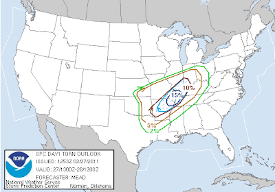
Below are the latest SPC severe weather probability maps for today and tonight.  Keep in mind that it's more important to focus on the areas with a higher probability (i.e., 10% or greater) of these events occurring, rather than the actual percent chance themselves.  The first map is for tornadoes:


Strong and/or longer track tornadoes are forecast by the SPC within the light blue hatched areas on the map above.  This covers a region from central Arkansas, Northeastward to the confluence of the Mississippi and Ohio Rivers.

Below is the SPC probability of severe thunderstorm winds:


...and finally, severe hail:


Below is the latest surface weather forecast of frontal positions valid at 6pm CST this evening:


As you can see, a cold front/dryline is forecast to extend from a surface low along the Kansas/Oklahoma border, southward into northwest Texas.  A warm front will extend from the same surface low, northeasward across Missouri and into the Ohio Valley.

At the same time, a strong disturbance in the mid and upper levels of the atmosphere will be lifting Northeast across the region (orange and red colored areas from New Mexico to Kansas on the image below):

GFS Computer Model Forecacast Valid 6pm CST 2/27/11

At this time it appears that initial severe thunderstorm development (see map below) will take place near the surface low/warm front/dryline intersection (also known as the "triple point") along the southcentral Kansas/northcentral Oklahoma border area late this afternoon or early this evening.  This activity will then move/develop East/Northeast along the warm front with time.  Large hail and damaging winds are the greatest threats in this area, however isolated tornadoes are also possible, particularly near the triple point and in areas  immediately along the warm front, where turning of the winds with height will be greatest.

A second area of severe storms is likely to develop (see map below) south of the warm front over central Arkansas by early evening, as upper level energy approaches from the West and interacts with very unstable air in this region.  These storms are expected to be particularly severe, with strong tornadoes possible.  This activity will develop East/Northeast into adjacent portions of Missouri, Tennessee, Illinois and Kentucky into the late evening and overnight hours.  

A third region of more isolated severe thunderstorm development (at least initially - see map below) is expected from eastern Oklahoma into extreme Western Arkansas.  Isolated thunderstorms may develop as early as late afternoon or early evening along the advancing dryline across central or eastern Oklahoma.  This activity would then likely congeal into a line and race Eastward across Arkansas later this evening or early tonight.  Isolated tornadoes are possible when the storms initially develop over Oklahoma, but as the activity congeals into a solid line, damaging thunderstorm wind gusts would be the greatest threat over western Arkansas.

Residents of all of the above areas are encouraged to remain on high alert, and be ready to take action if severe weather threatens.  Listen to local media or NOAA weather radio for the latest updates, watches and warnings this afternoon and evening.

This could be a particularly dangerous situation since the greater part of the severe weather threat (especially in area #2) is expected to take place after dark.  Have a plan in place to receive warnings via NOAA Weather Radio, text alert messages, or other means if you live in these areas.

Saturday, February 26, 2011

Average Date of Last Freeze

This time of year folks in the South start itching to get outside and do yard work, plant a garden, etc.  This bout of "spring fever" usually sparks the question - just when does the last freeze of the season typically take place?  


If you're in the tannish-greenish shaded regions on the map above, you're typically good to go by the end of February (which of course, is coming right at us).  This includes almost all of Florida and the immediate Gulf Coast, as well as parts of southern Arizona and California.

For a closer look at Texas and Oklahoma, (the two states with our highest blog readership) take a look at the images below:


Now, we all know that "average" and "normal" vs. reality are two (or three) entirely different things, especially when dealing with the weather.  

So, with that lovely fact pointed out, just how does this coming March look compared to "normal"?  Below is the latest temperature "departure from normal" forecast from the CPC for the month of March:


If the above forecast verifies, much of the southern and central Plains will experience "above normal" temperatures in March (reddish-orangish shaded regions on the map above).  This would tend to suggest that the "normal/average" last freeze dates would indeed be the latest date a freeze should threaten this year, if again at all.

The Pacific Northwest, California coast and Alaska are the only regions forecast to have "Below Normal" temperatures in March (blue shaded regions on the map above).

The remainder of the nation is forecast to have near normal temperatures during the month of March.

Significant Severe Weather Outbreak Likely Sunday


The above image shows the latest severe weather outlook for Sunday from the SPC in Norman, OK.


At this time it appears that the greatest risk of severe storms will take place across the "Moderate" risk area (red outlined region on the map above), from portions of extreme eastern Oklahoma, Eastward across southern Missouri and much of Arkansas, into western portions of Kentucky and Tennessee.  Ironically, this covers much of the same region that was battered by tornadoes and severe thunderstorms this past Thursday.


Isolated thunderstorms are expected to develop in the western portions of the slight risk area (green outlined region on the map above) by late afternoon or early evening on Sunday.  The threat will then increase and spread East/Northeastward with time, entering the Mississippi, Tennessee and lower Ohio River Valley areas during the early morning hours on Monday.


At this time it appears that the most significant severe weather threat, including the possibility of strong tornadoes, could occur after dark across portions of Missouri and Arkansas and adjacent portions of Illinois, Kentucky, Tennessee and Mississippi (pink outlined area on the severe weather probability map below):


Residents of this region should stay alert and have a severe weather plan ready, especially should threatening conditions develop after dark or later into the night.


A NOAA Weather Radio is an excellent tool for receiving nighttime severe weather warnings.  You can program most newer models to alert you only of storms affecting your specific county.  You can also choose to be alerted to only tornado warnings, or both severe thunderstorm and tornado warnings, watches, etc.  These radios are available at most major retailers including Wal-Mart, Target and Radio Shack.


If you have a smartphone (like a Blackberry or iPhone, for example), you can download apps to alert you of a severe weather warning for your area as well. One such example is My-Cast Weather by Garmin.  Some local media outlets (newspaper, television and radio stations) also offer a free or low cost 'text alert' service to warn you of impending severe weather as well.

Friday, February 25, 2011

Update on Nashville Area Tornadoes of Thursday Evening

The NWS in Nashville has completed its storm damage survey after the events of late Thursday evening.

As we anticipated in an earlier blog post, 2 tornado touchdowns have been confirmed in the metro Nashville area.  We'll refer to the 1st tornado as the "Antioch Tornado" and the 2nd as the "Lebanon Tornado".


Details on the Antioch (East Nashville area) Tornado:
Radar estimates suggest that the tornado touched down at approximately 10:02 pm EST in a residential area near Percy Priest Lake (southeast of the Nashville International Airport).  Click to enlarge the estimated track map with annotations below:  


Below is a short YouTube video taken by a resident showing damage to homes near the initiation point of the Antioch tornado:


Two churches also sustained significant roof damage when the tornado initially touched down near Butler and Smith Springs Roads:


Damage at Priest Lake Presbyterian Church

The tornado continued on to the Northeast across the Priest Lake Forest community with significant damage to numerous homes:


This also corresponds to the time and place where the tornado appears to have reached maximum width and strength, with winds estimated at 120 mph in some locations (see the purple encircled region on the track map above).

The tornado continued across Percy Priest Lake and entered Wilson county before lifting near Gladieville Circle and Stewarts Ferry Pike roads.


Below is an image from the NWS Doppler Radar near Nashville, taken when the storm was entering the Percy Priest Lake area (click to enlarge):


The yellow encircled region on the image shows the tornadic circulation as indicated by the radar.  Remember, green colors show winds blowing toward the radar (which is represented by the small black dot toward the lower left corner of the image) and red colors show winds blowing away from the radar).


Details on the "Lebanon" area Tornado:
Radar estimates would suggest that the tornado touched down at approximately 10:14 pm EST, just South of Central Pike on Gladeville Road (click to enlarge my approximate map with annotations below):


Based on ground-truth damage observations, the tornado remained on the ground for approximately 8 miles.  The end point is near the intersection of I-40 and South Cumberland Street, just South of Lebanon.


Below is a YouTube video showing damage to homes near Lebanon:


Maximum sustained winds are estimated to have reached 120 mph (EF2 Strength) near the midpoint of the tornado's path.  In this same region, the maximum tornado width of 150 yards was reached.  Major damage to warehouse roofs and outer walls was observed in this area:


A high tension power line truss was bent completely in half in this region as well, between Franklin Road and Highway 840:


Below is an image from the NWS Doppler Radar near Nashville, taken when the storm was approaching I-40 just South of Lebanon (click to enlarge):


The yellow encircled region on the image shows the tornadic circulation as indicated by the radar.  Remember, green colors show winds blowing toward the radar (which is represented by the small black dot toward the lower left corner of the image) and red colors show winds blowing away from the radar).


Amazingly, there were no fatalities, and only 2 relatively minor injuries reported.  This is certainly a strong testament to the severe weather watch and warning system that was in place on Thursday evening!


All damage photographs courtesy The Tennessean.

Tornado, High Winds Hit Nashville Area...


The above image is zoomed-in on the Nashville area, and details the storm reports that have been received so far from yesterday evening's storms across the region (click to enlarge).

At this time it appears there were at least two tornado touch-downs (a detailed NWS storm survey will be forthcoming) and several reports of wind damage across the city.  The East/Southeast sides of town were particularly hard hit, with major damage to a church and over 100 homes in the Percy Priest Reservoir area.  Damage was also reported at the Hickory Hollow Mall near Antioch.

So far there are no reported deaths, which is certainly good news.

Below are some photos of storm damage around the city:


I'll post the NWS survey findings as soon as they are available.

Thursday, February 24, 2011

Storms Today Not Particularly "Chaser Friendly"

In my last post I remarked that the most intense thunderstorm cells over east-central Oklahoma are currently moving at a forward speed of about 60 mph.  This is due to a very strong Southwesterly jet stream flowing over the region, as shown in the image below:


The above image, valid at 11am CST, shows Southwest winds blowing at 80-85 mph (brightest purple shaded areas over Texas, Oklahoma and southwest Arkansas) at the main steering level of the atmosphere (often referred to as the "mid-levels") over the area.

This very fast storm motion, along with the fact that the greatest threat area for significant tornadoes today is in a somewhat hilly, tree-laden region, is what chasers would call an "unfriendly" chasing situation.  It's very hard to keep up with such fast moving storms in a car, and the hills and trees make it difficult to see anything even if you are able to catch it.

Tornado, partially obscured by trees & hills, near Atkins, AR on 2-6-08

The same ingredients that make this situation undesirable for chasers are also what unfortunately make for a very dangerous situation for the public in this area.  Storms will be very fast moving, and a tornado could occur with little to no advance warning.  This is especially the case when storms are in their infancy stages and are just beginning to exhibit a tornado threat.

Residents of Arkansas and adjacent portions of Mississippi and Tennessee should remain on a high state of alert this afternoon & evening and be ready to seek shelter if threatening weather approaches.