The National Weather Service has issued a Winter Storm Watch for much of southcentral Texas, including the Austin-San Antonio corridor and points East, for Thursday night and Friday morning.
I'm a big fan of winter weather, and we don't get much of it down this way, but I must say I had to chuckle when I saw the Watch being issued. After observing the deluge of ice and snow over a 2,000 mile swath of the nation the last 2 days, it seems almost comical to issue a Winter Storm Watch along with a forecast of 1-3 inches of snow. But then again, we are talking about South Texas - and everything, especially having to do with the weather, is relative!
Right now, it looks to me like the Austin/San Antonio areas can expect about 1 inch of snow on average Thursday night and Friday morning. Areas further East of I-35 could receive 2-3 inches in some spots.

I'll continue monitoring computer models and other data and post a more precise forecast/outlook tomorrow...
If you're getting really excited and want to make sure you measure the snow properly, you might want to take a look at this guide.
I'm a big fan of winter weather, and we don't get much of it down this way, but I must say I had to chuckle when I saw the Watch being issued. After observing the deluge of ice and snow over a 2,000 mile swath of the nation the last 2 days, it seems almost comical to issue a Winter Storm Watch along with a forecast of 1-3 inches of snow. But then again, we are talking about South Texas - and everything, especially having to do with the weather, is relative!
Right now, it looks to me like the Austin/San Antonio areas can expect about 1 inch of snow on average Thursday night and Friday morning. Areas further East of I-35 could receive 2-3 inches in some spots.
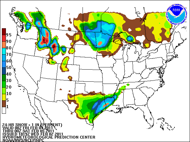
NWS Probability of at least 1 inch of Snow 6pm Thursday-6pm Friday
If you're getting really excited and want to make sure you measure the snow properly, you might want to take a look at this guide.
No comments:
Post a Comment