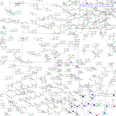
The latest surface map above depicts bitterly cold, arctic like conditions over the snowpack in Oklahoma, Arkansas, and adjacent portions of Kansas & Missouri.
In case you don't recall how to read the station plots on the map, the air temperature is the red number on the upper left side of each station plot.
The coldest reading I could find was -26 in Bartlesville, OK, followed by a comparitively balmy -20 in Grove. Fayetteville, AR is -17 and Tulsa is -11.
Below is a map with temperatures depicted like you'd normally see them on a TV station, but with less cities reported:
We've gone from an extreme snow situation to an extreme cold situation in less than 24 hours. The skies cleared out over the region overnight and the "heat" that had built up during the day was quickly radiated out by the deep snow on the ground, resulting in the deep freeze that we see this morning.
This is literally dangerous cold, particularly for those in a region that are not use to seeing this! You don't want to go outside with readings this low. If you were to get into your car and then have a breakdown, the results could be deadly, especially in rural areas with little or no traffic to bring you aid. In short - stay inside this morning until temperatures begin to moderate.
Temperatures will moderate today as the sun gets up and goes to work, but readings will not crack freezing today, mostly remaining in the 20s - but at least the 20s above zero!
Although temperatures won't crack freezing, the sun being out will slowly begin the melting process in what has become the arctic tundra of Arkansas and Oklahoma!
With plenty of snow remaining on the ground, the region will be in for another cold night tonight, but not as cold as this morning. Most low temperatures will range from zero to 10 above tonight across the region.


No comments:
Post a Comment