
Friday, September 22, 2017
Wednesday, December 11, 2013
Are Computer Models Getting Better with Snow Forecasts?

I've been tweeting off and on for the last few days about the upcoming snow event for Chicago this morning (photo above courtesy CBS Chicago, shows slick road conditions in Bolingbrook - a Southern suburb of Chicago).
This was the second snow event in the last 10 days (the first was in Minneapolis last week) where nearly all of the short to medium range computer forecast models were very consistent in their snowfall forecasts from a relatively lengthy period out from the event, and did not fluctuate as the event approached.
Long time followers and weather buffs know that the computer models typically have a hard time with snow events, and tend to show large swings from run to run, especially a few days out. So the consistency here was impressive, if not even a bit scary at times...
The screen shot below (click to enlarge) shows a composite of the computer model snowfall forecast runs since midday yesterday. This particular view is centered on the western suburbs of Chicago, but it applies to most of the city in this particular case.

I've circled in red the computer model forecast "cluster" of values which generally called for up to 1 inch of snow, on average, this morning. The green line above the red circle, calling for 2-3 inches of snow, is the National Weather Service forecast that most of the public and media are accustomed to using.
Actual snowfall this morning averaged 0.5-1.0 inch at most Chicago area reporting stations. So, the long and short of this story is that the short to medium range forecast models nailed this one - and they had been forecasting similar values for at least the last 3 days, very consistently.
A similar situation took place in the Minneapolis/St. Paul area on Wednesday of last week, with an actual snowfall of 2 inches at most locations in the central and eastern metro (see map below), and an "official" NWS forecast of as many as 4-6 inches leading up to and during the event. There again, the model runs were very consistent in calling for amounts near 2 inches well ahead of the event and showed very little fluctuation throughout.

So, are the short to medium range models getting better at handling snow forecasts? Various tweaks, software and hardware upgrades were made to most of the models over the last 6-12 months, and I think we are indeed seeing some positive results.
This is obviously not a scientific study by any means. I only use the 2 most recent cases in the Chicago and Minneapolis areas because my company provides forecast and storm warning services for snow removal companies, hospitals and schools in both of those areas, so I naturally keep a close eye on them.
I will say that I am very impressed with how the models have handled the smaller, fast moving (and typically more difficult to forecast) events so far this young season. Granted, we have yet to see a "major" storm in either area, and I am anxious to see how the models will perform leading up to a larger event this winter.
Stay tuned for more!
Sunday, November 17, 2013
Rare "High Risk" for Tornadoes/Severe Storms Midwest & OH Valley Today...

A rarely issued (especially for November) "High Risk" of tornadoes and severe thunderstorms has been issued by the SPC for today in the Midwest and Ohio Valley region.
As we mentioned yesterday, please stay very alert in this region today. Storms will be fast moving, and due to the threat of extensive and intense wind damage with any severe storm, I highly recommend that you treat a Severe Thunderstorm Warning just as you would normally treat a Tornado Warning today, taking the same sheltering action when in harms way.
Thunderstorms will get underway by mid morning near the Western edge of the outlook areas, and race East/Northeast this afternoon and evening. The highest risk of tornadoes is within the "High" risk area, with widespread wind damage the primary threat otherwise, and extending throughout the "moderate" and "high" risk areas.
If you or someone you know will be attending the Ravens/Bears game in Chicago today, please make sure to identify sheltering options as you enter the stadium and move there quickly if your smartphone app indicates that a Severe Thunderstorm or Tornado Warning has been issued for that location.
Below is a forecast radar image from the high resolution HRRR model valid at kick-off (12 Noon CST):

If this model verifies, and there is a good chance it will, several possible supercell thunderstorms will be approaching the stadium from the West at kick-off.
The situation will evolve rapidly from midday, with a squall line forecast to develop across much of the moderate/high risk area by 3pm CST:

The highest tornado potential will be with isolated storms that form initially from mid to late morning, and then isolated cells ahead of the line this afternoon. Widespread, potentially significant, wind damage can be expected with all severe storms today, and especially as the more solid line forms this afternoon.
Thunderstorms will be very fast moving today across the entire threat area, so there will be little reaction time available. If a warning is issued for your area, please seek immediate shelter.
For more information from 'The Original Weather Blog', including shorter, more frequent posts during rapidly changing weather events, please be sure to follow me on facebook and twitter:


Saturday, November 16, 2013
Regional Severe Weather Episode Likely for N. MO, S.E. IA and W. IL Tonight....
For good reason, a lot of attention is being paid to the expected severe weather episode across the Tennessee and Ohio Valley region for tomorrow. As I mentioned in a post earlier this morning, that event has the potential to impact a large number of people with widespread, damaging winds and a few tornadoes.
With all of the attention being paid to tomorrow, I'm afraid that another event that appears to be taking shape for late this evening and tonight is being flat overlooked or quickly "brushed over". Below is the latest WeatherGuidance severe weather outlook for this evening and tonight:

I am particularly concerned because 100% of the associated threat will take place after dark, and a significant portion of the threat will take place after Midnight, into the pre-dawn hours of Sunday.
Below is a forecast radar image from the high resolution NAM computer model, valid 8:00 PM this evening. While it's important not to take the indicated storm positions literally, you get the idea that there will be isolated to scattered thunderstorms beginning to develop over northwestern Missouri around or shortly after that time period:


As I pointed out earlier, it is important not to take the forecast radar positions literally, so in general, folks across the Northern third of Missouri, the Southeastern third of Iowa, and west-central/northwest Illinois should be particularly alert for thunderstorm development late this evening and tonight.
If you live in or near the green shaded area on the top image, please make sure that you have a way to receive weather warnings overnight tonight, and have a sheltering plan in place before you go to bed, that way you can move there quickly if threatening weather is observed or a warning is issued for your area.
With all of the attention being paid to tomorrow, I'm afraid that another event that appears to be taking shape for late this evening and tonight is being flat overlooked or quickly "brushed over". Below is the latest WeatherGuidance severe weather outlook for this evening and tonight:

I am particularly concerned because 100% of the associated threat will take place after dark, and a significant portion of the threat will take place after Midnight, into the pre-dawn hours of Sunday.
Below is a forecast radar image from the high resolution NAM computer model, valid 8:00 PM this evening. While it's important not to take the indicated storm positions literally, you get the idea that there will be isolated to scattered thunderstorms beginning to develop over northwestern Missouri around or shortly after that time period:

Jump ahead to 12 Midnight CST, and quite a cluster of strong to severe storms is depicted over southeast Iowa, northeast Missouri and west-central Illinois:

As these storms initially form late this evening and early tonight, large hail will be the primary threat. As we move on in time toward and after 12 Midnight, a risk of tornadoes will also increase, as low to mid level wind profiles become more favorable for such development.
As I pointed out earlier, it is important not to take the forecast radar positions literally, so in general, folks across the Northern third of Missouri, the Southeastern third of Iowa, and west-central/northwest Illinois should be particularly alert for thunderstorm development late this evening and tonight.
If you live in or near the green shaded area on the top image, please make sure that you have a way to receive weather warnings overnight tonight, and have a sheltering plan in place before you go to bed, that way you can move there quickly if threatening weather is observed or a warning is issued for your area.
For more information from 'The Original Weather Blog', including shorter, more frequent posts during rapidly changing weather events, please be sure to follow me on facebook and twitter:
Significant Severe Weather Episode Likely Sunday Across the OH/TN Valley Region...

Late fall is known for an occasional outbreak of severe weather, and unfortunately it looks like tomorrow will be just such a case. While the threat of severe weather will exist generally along and East of the Mississippi River, the most widespread and potentially dangerous situation appears to be taking shape for much of the Ohio and Tennessee Valley region, as indicated in yellow on the above image.
By far, wind damage will be the primary threat from this event. The potential exists for widespread, significant wind damage, particularly within the yellow shaded area on the image above.
A few tornadoes will also be possible, particularly early in the event when a few isolated storms may form along or ahead of the main line. All storms, as well as any tornadoes, will be very fast moving, which will further increase the risk of people being caught off guard if they're not paying attention to the weather. The primary risk will occur from afternoon into the evening, then spreading East overnight.
Below is the NAM forecast model depiction of what the radar may look like at 3:00 PM CST tomorrow:

As you can see, the model is already depicting a line of severe thunderstorms along the cold front by that time, but if you look closely toward the Southern end of the line, you'll see a few isolated cells, as well as a few isolated cells ahead of the line over Indiana and Kentucky. While it's important not to focus on the exact locations of where storms are depicted by the model, it does give us a good idea as to the overall scenario that is likely to take shape. Any isolated storms that form would need to be watched closely for tornado potential.
In addition to the "traditional" tornado threat associated with any isolated supercells that are able to form ahead of the main line, this is likely to be a situation where numerous "spin-ups" will occur along bowing segments within the overall line of storms throughout the event. While any tornado touch downs with these line segments are likely to be brief, the associated wind damage potential will be intense.
If you live across the areas indicated above or have travel plans into this region on Sunday, especially from midday Sunday into the afternoon and evening, please stay aware of the weather and be ready to seek immediate shelter if you find yourself in a dangerous situation. Storms will be very fast moving, so there will be little time to react in many cases, unfortunately. Due to the potential for intense damaging winds, I also recommend treating a Severe Thunderstorm Warning as you would a Tornado Warning, especially in the yellow shaded area on the top image.
For more information from 'The Original Weather Blog', including shorter, more frequent posts during rapidly changing weather events, please be sure to follow me on facebook and twitter:
Friday, October 4, 2013
Potent Round of Severe Weather Likely Later Today/Tonight...
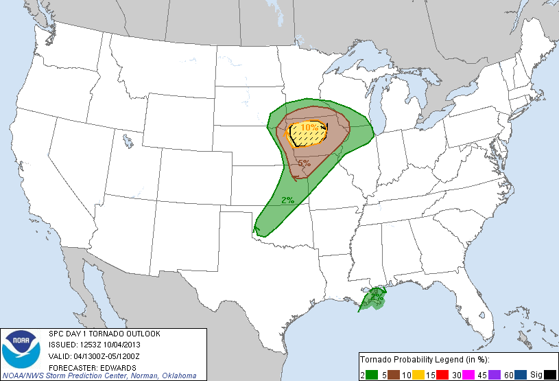
After a preview yesterday evening in southeast Nebraska, severe weather activity has waned a bit over the last several hours. However, folks in the upper Mississippi Valley and portions of the Midwest should not let their guards down - an even more potent threat of severe weather is on tap later this afternoon into this evening and tonight.
Above is the latest severe weather outlook for today and tonight, and is the portion that specifically addresses the potential for tornadoes, which will be highest within the brown and yellow shaded areas. A strong tornado or two is also possible, mainly within the black hatched area.
A threat for large hail and damaging winds will extend well to the South into portions of Oklahoma and northwest Texas as well, with some of the hail likely to exceed 2 inches in diameter in the black hatched areas on this image:

It's been awhile since we've seen a pronounced severe weather threat across a good chunk of the nation, so please be sure to keep an eye to the sky and listen for local updates and warnings as the afternoon and evening progresses.
Unfortunately, a good deal of the activity will take place after dark and into tonight. If you live across this region, please make sure that you have a way to receive weather warnings at night.
For more information from 'The Original Weather Blog', including shorter, more frequent posts during rapidly changing weather events, please be sure to follow me on facebook and twitter:
Wednesday, October 2, 2013
Tropical System Forming Near Cuba Bears Watching...

The tropical system forming just Southwest of the Western tip of Cuba (as shown in the visible satellite image above) is becoming much better organized as of early afternoon today.
I fully expect this system to be named a Depression or Tropical Storm later today.
This system could eventually impact portions of the U.S. Gulf Coast, most likely from Mississippi on Eastward:

There are many variables still at play here, but at this time it appears the most likely U.S. impacts would take place during the 2nd half of this weekend into the first part of next week.
If you live along the U.S. Gulf Coast in the indicated areas, please keep an eye on this system over the coming days. We'll post pertinent information as it becomes better organized...
For more information from 'The Original Weather Blog', including shorter, more frequent posts during rapidly changing weather events, please be sure to follow me on facebook and twitter:
Subscribe to:
Posts (Atom)