Wednesday, June 12, 2013

Significant Severe Weather Episodes Likely Today and Tomorrow...


As mentioned in a post on Monday, the potential exists for a significant wind damage event from late this afternoon into this evening and tonight over a large portion of the Midwest and Ohio Valley region.  The area at greatest risk is within the yellow shaded and lavender hatched area on the above image, which includes the cities of Chicago, Indianapolis, Ft. Wayne and Columbus.

The activity may initially begin with one or more isolated, supercell type storms, particularly over extreme eastern Iowa into northern Illinois, where a strong tornado or two cannot be ruled out before the activity congeals into a larger complex later this evening.

Once the larger bow echo and/or thunderstorm complex forms, it will race East/Southeastward, producing very damaging winds in excess of hurricane force over a potentially large area across the Ohio Valley region into tonight.  People across this region should prepare for the possibility of extended duration power outages as a result of the widespread high wind threat.

If you live across this region, please be very alert from mid to late afternoon into the evening and nighttime hours.  Make sure that you have a way to receive weather warnings, including during the overnight hours tonight.

Due to the potential intensity of the wind with these storms, this is one of those rare situations where I would recommend that you treat a Severe Thunderstorm Warning the same way that you would treat a Tornado Warning.  Seek shelter below ground if possible, or in a small interior room away from outside walls and windows until the storm passes your location.  

The threat of severe weather will shift Southeast into the Mid-Atlantic and Delmarva regions on Thursday, with widespread wind damage possible once again, especially within the reddish-orange shaded area on the image below:


For more information from 'The Original Weather Blog', including shorter, more frequent posts during rapidly changing weather events, please be sure to follow me on facebook and twitter:


Tuesday, June 11, 2013

Tropical Trouble for Texas / Mexico Next Week?

This is not a forecast, just something that will be interesting to watch from a computer model forecast performance perspective...

The last few runs of both the European and the U.S. based GFS computer models are forecasting a tropical system to develop in the Southwest part of the Gulf of Mexico late next week, with a possible impact somewhere along the Mexico and/or Texas coasts on Thursday or Friday, June 20-21:

European Forecast Model Valid 7pm CDT Thursday, 6/20/13

There's no doubt that tropical weather is very difficult to forecast beyond 120 hours, much less 240 hours in the future as in this case.  With that said, you may  also recall that last season the European Model in particular had a very strong track record in indicating potential tropical development, even at longer range time periods.  

This will be interesting to watch...and will be the first test of "long range" model accuracy in the tropics this season.

It also serves as a reminder to those along the western and central Gulf Coast that it would be a good time to review/prepare your Tropical Weather Emergency Kit and Safety/Preparedness Tips just in case a system does threaten your area later this season.

Stay tuned for updates on this over the coming days...

For more information from 'The Original Weather Blog', including shorter, more frequent posts during rapidly changing weather events, please be sure to follow me on facebook and twitter:


Monday, June 10, 2013

Severe Threat Includes Widespread Damaging Winds This Week...

As we head deeper into the summer months, the threat for "significant" tornado activity generally tends to decrease, while the threat for very damaging straight line wind gusts increases - and that's definitely the type of pattern that appears to be shaping up for this week.

Below are the latest severe weather outlooks for today through Wednesday, respectively:


Today's severe weather threat will be characterized by generally short-lived "pulse" type thunderstorms that pop-up, produce gusty winds and marginally severe hail in spots, and then rapidly diminish.  An isolated tornado or two cannot be ruled out, but this will not be the dominant form of severe weather today.

For Tuesday and Wednesday, the threat for organized and/or widespread wind damage will increase, particularly across the green shaded areas on the outlook for those days.  The primary threat will exist from late afternoon into the evening and early nighttime hours on Tuesday and Wednesday.

Some of the wind gusts may indeed become very damaging (i.e., in excess of 80 mph) and widespread in the indicated areas.  This is the type of situation where you should treat a "Severe Thunderstorm Warning" just as you would a Tornado Warning, and seek shelter in a small interior room on the lowest floor until the storms pass.  In other words, please don't treat this situation like a "garden variety severe thunderstorm" event or you could be placing yourself or your family at greater risk of injury.

Stay tuned for updates as we head further into the week...

For more information from 'The Original Weather Blog', including shorter, more frequent posts during rapidly changing weather events, please be sure to follow me on facebook and twitter:


Thursday, June 6, 2013

Tornado Threat Increasing Across Florida with T.S. Andrea...


The center of Tropical Storm Andrea is inching ever closer to the Florida "bend" at this hour, and the threat of tornadoes will continue to ramp up across the state today as this takes place...

The latest Tornado Watch is in effect until 10pm EDT:


Fortunately, with the center of Andrea so close to land, little in the way of additional strengthening is likely insofar as tropical characteristics are concerned.  

A deluge of heavy, potentially flooding rainfall will continue across Florida, southern Georgia and eventually South Carolina today, with the heavy rain forecast to spread North/Northeastward along the Eastern seaboard into the weekend:


For additional details, radar and satellite imagery on Tropical Storm Andrea, please click on the Tropical Weather link at the upper right hand corner of the blog homepage.

For more information from 'The Original Weather Blog', including shorter, more frequent posts during rapidly changing weather events, please be sure to follow me on facebook and twitter:


Tuesday, June 4, 2013

Surviving a Tornado Above Ground vs. Driving Away From It: More El Reno Tornado Controversy from 5-31-13...


Before the news of "storm chaser" deaths associated with the tornadoes near El Reno, OK on May 31, 2013, the big buzz within some parts of the media and across the entire severe weather safety community had to do with scenes like the one above - a heavily congested I-35 heading South out of Oklahoma City, away from the incoming storms.

So, what exactly are we looking at here?  Is this simply rush hour traffic on a Friday afternoon?  Is this a scene showing people attempting to flee the tornado warned area and get out of the danger zone?  Could it be some of both?  

Assuming that even part of the congestion was caused by folks attempting to flee the danger zone, why would they do that instead of "sheltering in place" as they have been advised to do for many years?  Was it because of the devastation that they had witnessed in Moore just over one week earlier, or were they following someone else's advice in a moment of fear and/or panic?  Again, could it be some of both?

If they were following another person's advice, chances are that it was that of meteorologist Mike Morgan at KFOR-TV.  Mike was part of KFOR's live coverage that was broadcast not only on their air, but also on radio stations and internet streams that afternoon and evening.  KFOR is also an NBC affiliate, so The Weather Channel (which is owned by NBC Universal) also carried significant portions of KFOR's coverage live, including segments like this one below.

Pay particular attention to Mike's words from about 0:50 to 1:25 into the video:


My main takeaway was that his advice to residents was:

• You can't survive this tornado if you're not underground
• Get away (in your vehicle) from the tornado if you don't have adequate shelter

This particular segment addressed the threat to residents of Yukon, but a very similar (if not identical) message was relayed as tornadoes threatened El Reno, south Oklahoma City and other areas as well.

So, was this good advice or was it not?  In my opinion, the answer is mostly "no", but to be completely fair, let's take a closer look at each point:

• "You can't survive this tornado if you're not underground..."  Obviously, that's not a true statement, as nothing is impossible when it comes to tornado survival.  In the least, this was a poor choice of words, but they were the same words that he would repeat numerous times that day.

With that said, it is absolutely true that if you want to ensure your survival in a strong or violent tornado situation, your best bet is always to shelter below ground.  This is not a news bulletin to anyone living in Oklahoma or other areas that are frequented by strong and violent tornadoes.  It's a fact of life (literally).

Another important point to remember when considering the underground vs. above ground sheltering option is that it's not necessarily a "direct hit" by a tornado that causes deaths.  More often than not, tornado deaths are the result of debris hitting the victim in the head, chest or torso, and that can happen well away from the actual "center" of the tornado's path.  This is the main reason, in my opinion, that getting below ground is always the best, safest option, if such an option is available...


...and many folks in this region do have such an option, either via a basement or storm cellar that has been in place for years, or via a storm shelter  that has been installed following violent tornado events of recent years).

Many folks in this area also have a friend or relative that has such an option if they don't have one of their own - but you have to assess the threat well ahead of time (i.e., when the Tornado Watch is issued - don't wait for the Warning) and be able to safely get to that location well before the actual threat exists.

• "Get away from the tornado if you don't have adequate shelter..." Very good advice, but not when you have only minutes to react.  This is particularly the case when you live in a heavily populated metropolitan area where roads can become congested quickly on their own, much less in an emergency evacuation type situation.

For years now, I've been advising residents of mobile homes and other vulnerable locations without a nearby sheltering option to leave their home and go to a friend or relative's house or other more suitable structure as soon as a Tornado Watch is issued for their area.  You absolutely do not want to try and flee by vehicle once you're in a warning situation, particularly in a heavily populated area where there is a potential for you to get stuck on a log jammed roadway.

Should you do this every time a Tornado Watch is issued?  That's a matter of personal opinion and is unique to your specific situation.  If you are "scared to death" in almost any tornado situation, then you probably should.  If you're only concerned about "the big one", you'll likely be given clues by trusted meteorologists and other sources before the event actually begins to unfold.  On my blog, I always use words like "pay particular attention to the weather in this area", or "one or more strong and/or long track tornadoes are possible today" when trying to get the word out about a particularly volatile situation.


After making repeated statements like the ones in the video above, many were understandably quick to jump on Mike Morgan's case over the weekend, particularly when it was revealed that several of the deaths in the OKC Metro area on Friday took place on roadways.  While I believe that his intentions were probably good, I feel that he delivered the advice either (1). using a poor choice and/or combination of words and/or (2). when it was too late for people to safely do something about their situation, potentially causing more of a "panic" mode.

In my opinion, the 12 Noon newscast that day (if not before) would have been the time to suggest that folks line up a more suitable sheltering option if they weren't comfortable with the one they would have later in the afternoon and evening.  That would have given folks some time to contact a friend or relative, make a plan and not have to rush out in a moment of panic into a potentially dangerous situation.

The fact of the matter is that we'll probably never know why all of the people that did choose to flee made that decision on Friday.  Not everyone in OKC watches KFOR-TV or The Weather Channel.  I feel that many probably reacted that way when they heard that another potentially devastating tornado was headed their way again, especially after what they had witnessed in Moore the week before.  Add some traditional and/or social media "hysteria" to the mix, and you have all of the necessary ingredients for a full blown panic situation for some.

Without a doubt, the combination of rush hour traffic, people fleeing based on bad advice and people fleeing based on their own fear of the situation turned out to be a major problem for almost all involved, and it may have even resulted in death for a select number (although that is difficult to quantify based on the information that we have to date).  A tragic situation anyway you look at it, and one that could have been avoided last Friday and should be avoided in the future.

"No Other Options"

So, what do you do if you don't have an underground shelter and a strong or violent tornado will potentially affect your location in minutes?

Do the same thing you've been told to do since Kindergarten:  get in a small interior room or hallway on the lowest floor of your location and cover your head and upper body as much as possible.

Bathrooms and closets offer great protection, but be sure to put as many walls between you and the exterior of your location as possible (don't go to one on the outside wall).  The bathroom is probably the best option in this case, as the pipes in the walls may offer additional support and protection.

If you have a bicycle, motorcycle, football or other type of "crash helmet", put it on, especially on the kids.  Head injuries are among the leading causes of tornado fatalities, particularly in children.  


"Caught In the Car"

If you are caught in your vehicle and a tornado is approaching (whether you're stuck in rush hour traffic, blocked by a flooded road or took some bad advice and tried to run away from the tornado when it was too late), by all means get out of the vehicle!

I was shocked and appalled to see the American Red Cross of all people recommend last year that it was "safe" to stay seat belted in your car if a tornado was approaching.  I could not disagree more, and the statistics from Joplin, Moore, and most recently in El Reno prove that without a doubt, a vehicle is no safe place to be during a strong or violent tornado.


If you are caught in your vehicle and have no way to safely get out of the situation, leave your car immediately and lay low in a ditch, ravine or other low spot.  Again, cover your head and upper body as much as possible, and if you have a helmet available, put it on!

As I always try to point out, you can survive a tornado regardless of your circumstances.  The main thing is to plan ahead, that way you are less likely to panic and make a bad decision when the critical time does come.

Our thoughts and prayers continue to be with the folks that have been devastated by tornadoes over the last month, and we hope that the worst of this season is behind us - but please take some time to prepare and have a safety action plan in place now, just in case another threat does develop in your area.

For more information from 'The Original Weather Blog', including shorter, more frequent posts during rapidly changing weather events, please be sure to follow me on facebook and twitter:


Monday, June 3, 2013

Thoughts on the Death of Tim Samaras; Overall Tornado Chase Situation in El Reno OK on 5-31-13...


I was both shocked and saddened to hear that severe weather researcher and storm chaser Tim Samaras (pictured above, photo courtesy National Geographic) was one of those killed by tornadoes in the Oklahoma City / El Reno areas on Friday afternoon, May 31, 2013.

Tim was not the type of storm chaser that you'd "expect" to see in that type of headline.  If I had to use three words to describe Tim's approach to tornado chasing they would be experienced, professional and cautious.  He was certainly not what I would call a "hot shot", nor was he out there to make himself famous via dramatic, too close for comfort photos and/or videos.  He was a severe weather researcher - a true scientist and had done work sponsored by both the National Science Foundation and the National Geographic Society.

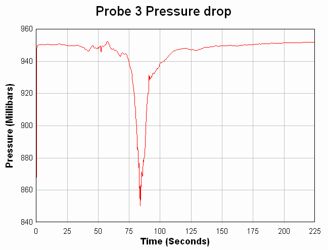
With that said, let's be brutally honest about something:  One of Tim's primary missions was to place meteorological instrument packages in the paths of oncoming tornadoes.  He had been doing this for years, and with considerable success.  In fact, on June 24, 2003, one of his probes measured the steepest pressure drop in the world (100mb in 40 seconds) as an EF-4 intensity tornado passed over the probe near Manchester South Dakota:


Why do I say "let's be brutally honest" when leading into this part of the discussion?  Because when your mission is to place probes or other devices in the path of an oncoming tornado, sooner or later, no matter how cautious and/or experienced you are, the odds of something "bad" happening are bound to catch up with you.  

Under such a scenario, "bad" could range from as little as your vehicle being stranded on a flooded roadway or damaged by flying debris, to the ultimate definition of the term - your seemingly untimely death.  Unfortunately, the latter form of the word was exactly what happened to Tim and his crew on Friday (his son, Paul Samaras, age 24, and fellow researcher/chaser Carl Young, age 45, were also killed).

I cannot confirm that the photo below is indeed one of Tim's research vehicles after coming in contact with a tornado near El Reno on Friday, but "major" media outlets in the Oklahoma City area are reporting it as such:


Regardless of who's vehicle this was, the destruction is noteworthy from an educational standpoint.  That's the engine block laying out beside the vehicle, which had been carried some distance before being dropped and/or thrown by the tornado.  A vehicle is no place to be during a tornado, despite some shocking "advice" to the contrary that came out from the American Red Cross of all places last year.  I wholeheartedly disagree with anyone who says it's safer to ride out a tornado in your vehicle than in a ditch, ravine or other low lying area.  I think the image above (as well as countless others from Moore earlier in May as well as other events) speaks for itself on that point.

According to the medical examiner's office, Tim's body was found still seat belted in his vehicle, while the other two members of his crew were removed from their vehicle and their bodies were found some distance away (reportedly 1/2 mile or more).

I do not report the above information to be morbid or to show lack of respect for those lost, I am doing it to further prove a point:  tornado chasing is a serious, very dangerous business.  I know Tim counseled "up and coming" chasers to that end before, and I am sure he would continue to do that now if he had the opportunity.  It's not a game or a contest to see who can be closest and first with dramatic videos - it's serious business.

So, how did the odds catch up to him, and why were the results so deadly?  There were likely multiple factors at play, but I think one overall theme is emerging from the events of Friday:  this was a complex supercell thunderstorm, which did not behave "normally" in many ways.

The El Reno / south OKC supercell was very large and had multiple circulations taking place at (or very near) the same time.  Meteorologists (and presumably storm chasers) know that a major circulation will "cycle" from time to time.  That is where the original circulation weakens and/or diminishes and is replaced by a new circulation to the right or left of the original.  

The photo below captures what was likely one of several "cycles" that took place with the El Reno storm on Friday.  It was taken by the Basehunters storm chase team:


Note the remnant/decreasing circulation on the right, and  the newly forming circulation and condensation funnel on the left.

In the above photo, the replacement tornado was relatively close to the original.  This is not always the case, as a considerable distance can exist between the two (actually, that is quite common).

Another hazard in the "cycle" situation is that the parent thunderstorm can also send out a significant amount of non-tornadic downburst and/or straight line winds when the transition is taking place.  I found myself caught by such a burst of wind in Nebraska on a chase way back in 1990, and I was nearly blown off of the road in my chase vehicle.  I believe this is what happened to the Weather Channel's chase team on Friday when their vehicle was flipped over, rolled and heavily damaged (thankfully, all were able to walk away):


After my experience in 1990, I increased the distance that I had already set for myself as far as how close I would get to the parent circulation of a supercell.  That's easy to do if you're just plain "chasing", but if your mission is to place probes in front of the tornado's likely path, increasing the "safe zone" can be a difficult task to achieve.

Another contributing factor was that this supercell was what we call "high precipitation" meaning it contained copious amounts of torrential rain and hail, both of which can obscure the general circulation and tornado threat considerably.

Flash Flood Warnings were in effect simultaneously with tornado warnings on Friday, which creates another potential hazard for those out on the roadways.  The radar snapshot below shows a close-up of the OKC Metro and the storm in question on Friday.  As you can see, heavy rain and hail (yellows and reds) were widespread and extended almost in all directions from the parent circulation, which as of the time of this image was circled in white:


The bottom line is that if you find yourself too close to the beast (meaning the general circulation or mesocyclone) in such a large supercell and a cycle begins to take place quickly, as was the case multiple times on Friday, you can be caught off guard and the results can be disastrous.

I've (thus far) silently observed calls this weekend for storm chasing to be "banned" or for a permit or license to be required.  That's pure nonsense.  You can't legislate or regulate a human being's right to observe his or her natural surroundings (or at least you shouldn't be able to if we truly reside in a free land).

Lots of things in life are dangerous.  Do you need a permit to climb a mountain?  How about the rattle snake hunts that are held in various parts of the southwest each year?  As far as I know, you don't need a permit to participate, and quite frankly, I'd rather responsibly chase a tornado any day rather than poke around under rocks for venomous snakes who are ultimately unhappy to see me.

In my opinion, many in the "mainstream" are far to quick to call for government intervention now days.  This all comes down to personal responsibility.  Anyone is free to go out and observe the wonders of nature, which includes violent thunderstorms and tornadoes, and that's the way it ought to be.  But as I always caution folks (and I know that Tim did, too), the inexperienced should never attempt to do this alone - always make sure that an experienced chaser is on board.

Sadly, knowledge and experience did not save Tim and his crew on Friday.  While this was a tragic event, it is extremely rare for the thunderstorm or tornado itself to kill a storm chaser.  Most serious injuries and/or deaths of chasers in the past have been the result of a car accident, completely unrelated to the situation at hand.

The "media frenzy" surrounding tornado and severe weather events in recent years also brings this issue to the forefront, and it will be interesting to see how this plays out in the longer term.

To summarize, my thoughts are:  Ban or regulate storm chasing?  No.  Encourage responsibility, common sense and the utmost caution, including (and in some cases, especially) among members of the media?  Yes.

For more information from 'The Original Weather Blog', including shorter, more frequent posts during rapidly changing weather events, please be sure to follow me on facebook and twitter:
 

Severe Weather Threat Increasing Again Today thru Wednesday...

After a (thankfully) relatively quiet period with only isolated to scattered severe weather events on Saturday and Sunday, it looks like we're going to be lunged back into a more active pattern for this week...especially the first half of the week.

Below are the severe weather outlooks for today through Wednesday, respectively:


Right now, it appears that the most active day will likely be tomorrow, Tuesday, as the combination of middle and upper level jet stream winds and Southerly low level winds will be strongest during the afternoon and evening hours across portions of the central and southern High Plains.  This type of set up is likely to produce some of the more organized storms of the week, with the potential for very large hail and tornadoes with the strongest storms.

Otherwise, there will be a risk for damaging winds, large hail and a few tornadoes with severe storms today through Wednesday, with the highest risk located within the green and reddish-orange shaded areas on the above images.

The threat of severe weather will shift East/Southeast into portions of the Mississippi, Ohio and Tennessee Valley Regions on Thursday and/or Friday, but at this time there is too much uncertainty regarding the placement of low level boundaries to focus in on a particular area for an elevated threat.  Stay tuned for updates on that as we move through the week.

If you live or have travel plans across the severe weather threat areas, please stay alert, particularly during the afternoon and evening hours.  Make sure you have a plan in place ahead of time so that you can quickly get to shelter if threatening weather is observed or a warning is issued.

For more information from 'The Original Weather Blog', including shorter, more frequent posts during rapidly changing weather events, please be sure to follow me on facebook and twitter: