Thursday, May 31, 2012

Severe Weather Threat Ahead of Cool Front Today...


Severe thunderstorms are forecast across a broad region today, ahead of a slow moving frontal boundary. The risk of severe weather is present throughout the yellow shaded area on the above image, from the Midwest and Ohio Valley, Southwestward into the middle and lower Mississippi Valley and central through southern Texas.

In general, severe thunderstorms are forecast during the afternoon and evening hours, primarily after 2pm, as the atmosphere heats up and becomes unstable ahead of the frontal boundary.  This instability will interact with several disturbances in the upper-atmosphere to produce strong to locally severe storms in this region.

Large hail and damaging wind gusts are the primary threats across this region today.  While an isolated tornado or two cannot be ruled out, this threat is not "high" in any particular area.  A localized tornado threat would be greatest in association with any thunderstorm that is able to remain isolated and become well organized, generally within the first 1-3 hours of development.

There is a heightened risk of damaging wind potential across portions of the Ohio and Tennessee Valley, into the lower Mississippi Valley, within the red shaded area on this image:


There is also a "conditional" risk of particularly large hail, in excess of 2 inches in diameter, with any storms that form within the black hatched region in Texas, as shown on the image below:


I note that the very large hail risk is "conditional" in southwest and southcentral Texas because first thunderstorms must develop in order for this threat to be realized.  Coverage of thunderstorm activity is only expected to average 20-30% across this region, mainly due to the presence of a strong capping inversion.  While there is only a 20-30% chance of a thunderstorm occurring in this region, there is a near 100% chance that severe weather will take place in association with any storm that does develop.

Folks living across all of the above mentioned severe weather threat areas should remain alert today.  Listen to NOAA Weather Radio, local media or another trusted source for later statements and possible warnings.  Please take a few moments to familiarize yourself with your best sheltering option, and be prepared to move there quickly if threatening weather is observed or a warning is issued for your area.

For more information, including "live blogging" during rapidly changing weather events, please be sure to follow me on facebook and/or twitter:


Wednesday, May 30, 2012

Severe Storms Threaten Much of the Same Area in the Plains Again Today...


Massive hailstones like the one pictured above (via Fox News in OKC) will be falling again today across much of the same area in Oklahoma.  The latest severe weather outlook for this afternoon into tonight from the SPC is shown below:


Severe storms are forecast within the yellow shaded areas on the image, from southwest Nebraska through western and southern Kansas, much of Oklahoma, north Texas and western Arkansas.  An enhanced risk of widespread and potent severe weather is forecast within the red shaded area on the same image, which includes much of western Oklahoma and extreme northwest Texas.

The situation is expected to unfold much like yesterday, with thunderstorms initiating near the Western edge of the outlook area during the mid to late afternoon hours and increasing into the evening as the activity moves and/or develops Eastward.
Very large hail of 2 inches in diameter or greater, damaging thunderstorm wind gusts and a few tornadoes can be expected.  The highest risk of 2 inch or larger hail and tornadoes lies within the lavender shaded and black hatched area on the image below (which once again includes the Oklahoma City Metropolitan area):


The greatest chance of a tornado will take place with individual storms that are able to remain isolated and become well organized, especially during the first few hours of development late this afternoon into early to mid evening.  We didn't really see this type of activity much yesterday, but conditions are a bit more favorable today, so I suspect we'll see isolated to scattered tornadoes within the red shaded risk area.

If you live across this region, please stay alert today.  Listen to NOAA Weather Radio or another trusted source for later statements and possible warnings.  Be sure to identify your best sheltering option ahead of time, and be prepared to move there quickly if severe weather is observed or a warning issued.

For more information, including "live blogging" during rapidly changing weather events, please be sure to follow me on facebook and/or twitter:


Tuesday, May 29, 2012

Tornado Watch Upstate New York / Vermont...


I don't typically make posts about individual weather watch issuances anymore, especially with the "Severe Weather Watch" widget on the right hand side of the blog homepage that was added awhile back.

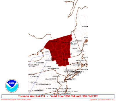
In this case, however, we've got a very unusual situation:  the issuance of a Tornado Watch for upstate New York, Vermont and western Massachusetts.

Thunderstorms are forming across the Hudson Valley region, and will become severe during the afternoon.  While large hail and damaging wind gusts are the primary threats, a few tornadoes cannot be ruled out, hence the issuance of the Tornado Watch.


I think another factor that plays into such a decision by the SPC is that tornadoes occur with relative infrequency in this region.  So, even an isolated tornado threat could potentially equate to a significant event in this region (and as we all know, everything is relative - especially when dealing with the weather!)

If you live across this region, please review your severe weather safety tips and be prepared to seek immediate shelter if threatening weather is observed or a warning is issued.

If you would like to monitor the regional radar, such as the image shown above, you can do so by going here.  You also have options to animate the imagery on that page as well.

If things get particularly active, we'll adjust a "floater" radar image with a close up view of the activity this afternoon.

For more information, including "live blogging" during rapidly changing weather events, please be sure to follow me on facebook and/or twitter:


Severe Weather Threat to Continue Central/Southern Plains Today and Wednesday...


There are two primary areas with an organized threat of severe thunderstorms for today, as indiciated within the yellow shaded areas on the above image.

The first region is across the central Plains.  Thunderstorms will develop late this afternoon or early this evening mainly near the Western edge of the outlook area, and spread Eastward throughout the evening hours and into at least early tonight.

Large hail will be the primary threat throughout the time period, with hailstones possibly exceeding 2 inches in diameter within the red shaded and black hatched area on the image below:


Isolated tornadoes are also possible, particularly within the first 1-3 hours after a thunderstorm develops.  This would particularly be the case with any storm that is able to remain isolated and become well organized.  By mid to late evening, one or more clusters or small complexes of thunderstorms are likely to develop and move East/Southeastward during the late evening and early tonight, with damaging wind gusts the primary severe weather threat by that time.

The second severe weather threat area for today lies across the Northeast and New England.  Thunderstorms are already underway this morning across the Ohio Valley.  This activity will grow stronger by midday and into the afternoon, with new development also taking place further to the Northeast across the severe weather outlook area.

Large hail and damaging wind gusts will be the primary threats in this region, although an isolated tornado cannot be ruled out from any storm that is able to become well organized and isolate itself from the larger area of activity.

On Wednesday, a significant threat of severe weather is expected across the central and southern Plains once again, but perhaps on an even more widespread basis for a small part of the region, as indicated in red on the image below:


While severe storms will be possible anywhere within the yellow shaded area on the image above, a concentrated risk appears to be taking shape from southwest Kansas into central and northern Oklahoma (as indicated in red).  

Large hail and damaging thunderstorm winds can be expected to be the primary threat, however a few tornadoes are also possible, particularly within the first few hours of initiation late tomorrow afternoon and evening.

Hail may become particularly large, in excess of 2 inches, within the red and lavender shaded and black hatched area on the image below:


Folks living across the severe weather threat areas for today and tomorrow should remain alert.  Take a few moments early on to ensure that your severe weather safety kit is well stocked.  Be sure to identify your best sheltering option and have it ready in case you need to go there quickly.  Please make sure that you have a way to receive severe weather warnings for your area, and be prepared to seek shelter immediately if threatening weather is observed or a warning is issued.

For all of the latest updates on the severe weather threat for both today and tomorrow, be sure to check on the Severe Weather Headquarters page at our sister site, WeatherGuidance.com.  This page is new and under near continuous development, so be sure to check back frequently for updated features and options over the coming hours and days.

For more information, including "live blogging" during rapidly changing weather events, please be sure to follow me on facebook and/or twitter:


Monday, May 28, 2012

Tropical Storm Beryl Pounding South Georgia and North Florida...


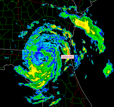
The above image was just taken from the Valdosta, GA area doppler radar site. You can see the center of Tropical Storm Beryl located 15 or so miles to the North of Lake City, FL, or about 15 miles South of the Georgia state line.

Widespread reports of 50-60 mph wind gusts continue, primarily on the Eastern side of the system over southeast Georgia and northeast Florida, with widespread downing of trees and power lines.

The other major threat at this time is very heavy rainfall.  Ironically, much of this region is in a severe drought, but anytime you get several inches of rain falling in a short period of time, there will be flash flooding threats.  The image below shows the radar's estimate as to the total precipitation thus far.  The brighter red shadings indicate 4-6 inches of rain, while the yellows indicate 2-4 inches so far:


Isolated tornadoes will also be a threat, primarily with thunderstorms that take place in the upper-right quadrant of the storm (with respect to the location of the center).  In the near term, this will primarily be over the extreme northeast corner of Florida, and southeast Georgia.

For all of the latest satellite and radar imagery, as well as updated track and intensity forecast information throughout the day, please see the dedicated page on Tropical Storm Beryl on our sister site, WeatherGuidance.com.


For more information, including "live blogging" during rapidly changing weather events, please be sure to follow me on facebook and/or twitter:


Sunday, May 27, 2012

Tropical Storm Beryl Continues to Organize; Tropical Storm Force Winds Nearing FL Coast...


Above is a high resolution visible satellite image showing the center of Tropical Storm Beryl at the center of the image. I have placed a red "X" at the center on the same image below for point of reference:


Thunderstorms have continued to develop and organize around the center during the afternoon, particularly within the Northwestern through Southeastern quadrants.  

You can't fully appreciate this visible imagery without seeing it animated.  Please go to this link to view the imagery in motion.  Caution:  it will take awhile for the frames to initially load, especially if you are on a slow internet connection.  The images are updated about every 10 minutes.  Use the "refresh" button on your browser to re-load the latest images (again, it will take awhile to reload each time you do this).

The center of the storm is still on track to make landfall along the Florida coast to the immediate South of the Jacksonville area, in the vicinity of St. Augustine, around Midnight tonight (EDT):


As of the 5pm EDT advisory, maximum sustained winds were estimated near 65 mph, with gusts just over hurricane force likely in stronger squalls.  A Hurricane Hunter aircraft is entering the system right now, and we may have further updates as to wind speed soon.

Tropical storm force wind gusts will spread onshore across northeast Florida shortly, and across adjacent portions of southeast Georgia by mid-evening.  Wind gusts to hurricane force will also be possible in this region.  Based on the current track and the current size of the wind field, the greatest risk of tropical storm force winds with gusts to hurricane force will extend from the Brunswick and St. Simon's Island, Georgia areas, Southward to near Palm Coast, Florida.

For the latest information as well as live satellite, radar and interactive tracking graphics, please see the Tropical Storm Beryl page on WeatherGuidance.com.

For more information, including "live blogging" during rapidly changing weather events, please be sure to follow me on facebook and/or twitter:


Severe Storms, Tornadoes Likely Central Plains This Afternoon & Evening...


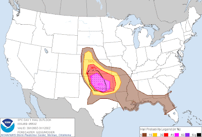
Severe thunderstorms are forecast to develop across the central and northern Plains later this afternoon and into this evening. The highest risk of severe storms will reside within the lavender and red shaded and black hatched areas on the above image.  

Very lage hail in excess of 2 inches in diameter, damaging thunderstorm winds and tornadoes are all possible with severe storms in this region.

Thunderstorms are forecast to develop along a dryline/frontal boundary feature near the Western edge of the outlook area by mid to late afternoon and progress East/Northeastward into this evening.

A more isolated severe threat is possible further South along the dryline in the brown shaded area from western Oklahoma into the Texas Panhandle region and southwest Texas.  Even though storms in this region will be more isolated, they will pose a significant severe weather threat to the affected areas.

If you live in any of the above mentioned regions, please remain alert this afternoon and evening.  Listen to NOAA Weather Radio, local media or another trusted source for the latest information, forecasts and possible warnings.  Be sure to identify your best sheltering option ahead of time, especially if you are in an unfamiliar area for holiday weekend activities.  

Be sure to check the Severe Weather Homepage on our sister site for the latest information throughout the day as well.  The new regional radar images are now up for your use/enjoyment!

For more information, including "live blogging" during rapidly changing weather events, please be sure to follow me on facebook and/or twitter:


Tropical Storm Beryl To Make Landfall Late This Evening/Tonight...


The center of (Sub) Tropical Storm Beryl is forecast to make landfall along the southeast Georgia / northeast Florida coastal bend between Midnight and 2am tonight / Monday morning.  This is based on the latest position and expected forward speed throughout the day.

It is important to keep in mind that this is when the center of the storm is forecast to make landfall.  Its effects will be felt across the region in an increasing fashion throughout the day, with respect to winds, rain, wave action and rip currents.  A Tropical Storm Warning is in effect throughout the region and beach activity is highly discouraged today and tonight.

For all of the latest, including close up views of the Jacksonville, FL and area radars, please go to the WeatherGuidance.com tropical page.  Information will be updated and new content will be added on that page throughout the day.


For more information, including "live blogging" during rapidly changing weather events, please be sure to follow me on facebook and/or twitter:


Saturday, May 26, 2012

Plains In for One, Two, Three Rounds of Severe Weather, Including Tornado Threat...

Below are the latest severe weather outlooks for today, Sunday and Monday, respectively, from the Storm Prediction Center (SPC) in Norman, OK:


In each case, severe thunderstorms are forecast within the yellow shaded areas on the indicated day.  Large hail, damaging wind gusts and tornadoes will be possible with severe storms each day this holiday weekend.

For this afternoon and evening, the risk of tornadoes is greatest within the brown shaded areas on the image below:


The risk of tornadoes will be even more pronounced on Sunday afternoon and evening, particularly within the red and black hatched areas on the image below.  Very large hail in excess of 2 inches in diameter is also possible in the same area:


If you live in these areas and have outdoor plans this weekend, please make sure to have a way to receive the latest severe weather information and warnings.  Be sure to identify your best sheltering option, especially when outdoors or in an unfamiliar area, and be prepared to go there quickly if threatening weather is observed or a warning is issued.

Please check the Severe Weather Homepage on our sister site, WeatherGuidance.com for additional updates.  The content of that page is under development, and you'll see upgrades throughout the weekend, including regional radar imagery and watch/warning information which will be up by the end of the day today!

For more information, including "live blogging" during rapidly changing weather events, please be sure to follow me on facebook and/or twitter:


"Subtropical" Storm Beryl Taking Aim on Southeast U.S....

As expected, the system over the southwest Atlantic has reorganized and is now called "Beyrl". Because the system is currently made up of both an upper-level and surface low pressure system, sort of a hybrid, if you will, it has been technically classified as a "subtropical storm".  


This is really a technical/meteorological distinction only, and folks in the path of this system should regard it just as they would any other tropical storm.  As such, all of the watch and warning products issued by the National Hurricane Center are also termed "Tropical Storm" as well.

If you have outdoor plans, especially from the northern Florida coast across the Georgia coast and the South Carolina coast this weekend, please pay very close attention to the progress of this system.

For all of the latest information throughout the holiday weekend, please see the dedicated page on WeatherGuidance.com.


For more information, including "live blogging" during rapidly changing weather events, please be sure to follow me on facebook and/or twitter:


Friday, May 25, 2012

High Likelihood of Tropical Development to Impact Southeast U.S. This Weekend...

The system that traversed South Florida and Cuba yesterday (as described in this post) has since moved out over the Bahamas and the southwest Atlantic.

This system continues to organize, and there is a high likelihood that it will become Tropical Storm Beryl over the next 24-36 hours.


For those that live or have interests in the Southeastern U.S. coastal region,  please don't be lulled into a false sense of security due to the fact that the system is moving slowly East/Northeast.  All major computer models forecast this system to turn back to the Southwest and make a run at the Southeast U.S. coast by the 2nd half of this holiday weekend (i.e., Sunday and Monday).

Full coverage can be found on the Tropical Atlantic page at our sister site, WeatherGuidance.com.  Additional information and imagery will be added to that link throughout the coming days, so please check it frequently for updates as this situation progresses.


For more information, including "live blogging" during rapidly changing weather events, please be sure to follow me on facebook and/or twitter:


Thursday, May 24, 2012

Disturbance Over Southeast Florida to Make an Encore Appearance Later This Weekend?


An area of disturbed weather is producing widespread shower and thunderstorm activity, as well as strong, gusty winds, across southeast Florida and the Bahamas at this hour.  

An observing station located 8 miles South/Southeast of Key Biscayne, FL measured a wind gust of 43 mph during the last hour.  The Dinner Key Lighthouse measured a wind gust of 41 mph at nearly the same time.  These wind gusts were not associated with thunderstorms, but with the area of low pressure itself.  Gusts associated with thunderstorm activity in the region have been as high as 53 mph at Key Biscayne Park in the last hour.

The National Hurricane Center is "monitoring" the area, but has not deemed this a tropical system as of yet.

My primary concern is this:  The system is slowly moving East/Northeast and will exit Florida for the most part later today.  I am afraid that this will lead to a false sense of security across Florida and the Southeast U.S. as the system moves out into the Southwestern Atlantic through the first part of the weekend.

NAM Model Valid 8pm EDT Saturday 5/26/12
Shows System Turning Back to the W-SW

The thing to watch is that several of the computer forecast models (such as the NAM, above) are calling for the system to recurve back to the Southwest and take another run at the Southeast U.S. and/or Florida by the second half of the holiday weekend, this time as a well organized tropical system.

If you live across Florida and the Southeast U.S., please keep an eye on this system over the weekend, especially if you have outdoor holiday plans for Sunday and/or Monday.

For all of the latest, including satellite and radar loops, etc., please go to the Tropical Page at WeatherGuidance.com.


For more information, including "live blogging" during rapidly changing weather events, please be sure to follow me on facebook and/or twitter: