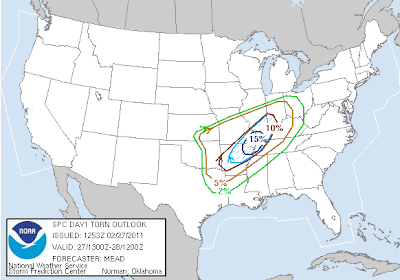
The above image shows the SPC's latest severe weather outlook for today. The red outlined area reflects a "moderate" risk of severe weather, while the green outlined area reflects a "slight" risk of severe weather. Any thunderstorm that develops within either area has a strong likelihood of becoming severe, but the coverage and intensity of the severe weather is likely to be the highest within the moderate risk area, at least the way things look at this time.
Below are the latest SPC severe weather probability maps for today and tonight. Keep in mind that it's more important to focus on the areas with a higher probability (i.e., 10% or greater) of these events occurring, rather than the actual percent chance themselves. The first map is for tornadoes:
Strong and/or longer track tornadoes are forecast by the SPC within the light blue hatched areas on the map above. This covers a region from central Arkansas, Northeastward to the confluence of the Mississippi and Ohio Rivers.
Below is the SPC probability of severe thunderstorm winds:
...and finally, severe hail:
Below is the latest surface weather forecast of frontal positions valid at 6pm CST this evening:
As you can see, a cold front/dryline is forecast to extend from a surface low along the Kansas/Oklahoma border, southward into northwest Texas. A warm front will extend from the same surface low, northeasward across Missouri and into the Ohio Valley.
At the same time, a strong disturbance in the mid and upper levels of the atmosphere will be lifting Northeast across the region (orange and red colored areas from New Mexico to Kansas on the image below):
GFS Computer Model Forecacast Valid 6pm CST 2/27/11
At this time it appears that initial severe thunderstorm development (see map below) will take place near the surface low/warm front/dryline intersection (also known as the "triple point") along the southcentral Kansas/northcentral Oklahoma border area late this afternoon or early this evening. This activity will then move/develop East/Northeast along the warm front with time. Large hail and damaging winds are the greatest threats in this area, however isolated tornadoes are also possible, particularly near the triple point and in areas immediately along the warm front, where turning of the winds with height will be greatest.
A second area of severe storms is likely to develop (see map below) south of the warm front over central Arkansas by early evening, as upper level energy approaches from the West and interacts with very unstable air in this region. These storms are expected to be particularly severe, with strong tornadoes possible. This activity will develop East/Northeast into adjacent portions of Missouri, Tennessee, Illinois and Kentucky into the late evening and overnight hours.
A third region of more isolated severe thunderstorm development (at least initially - see map below) is expected from eastern Oklahoma into extreme Western Arkansas. Isolated thunderstorms may develop as early as late afternoon or early evening along the advancing dryline across central or eastern Oklahoma. This activity would then likely congeal into a line and race Eastward across Arkansas later this evening or early tonight. Isolated tornadoes are possible when the storms initially develop over Oklahoma, but as the activity congeals into a solid line, damaging thunderstorm wind gusts would be the greatest threat over western Arkansas.
Residents of all of the above areas are encouraged to remain on high alert, and be ready to take action if severe weather threatens. Listen to local media or NOAA weather radio for the latest updates, watches and warnings this afternoon and evening.
This could be a particularly dangerous situation since the greater part of the severe weather threat (especially in area #2) is expected to take place after dark. Have a plan in place to receive warnings via NOAA Weather Radio, text alert messages, or other means if you live in these areas.


No comments:
Post a Comment