After blanketing portions of the Deep South with an unseasonably early snowfall last night, the same storm system is now beginning to produce snow across portions of Indiana and Michigan at this hour:
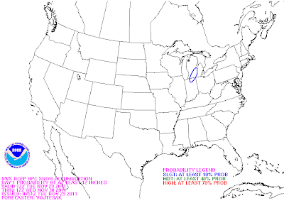
The snow will increase in coverage and intensity across the region during the afternoon and evening hours. Below are the latest forecasts from the HPC of the likelihood of 4, 8 and 12 inches of snow through tonight, respectively:
The snow will increase in coverage and intensity across the region during the afternoon and evening hours. Below are the latest forecasts from the HPC of the likelihood of 4, 8 and 12 inches of snow through tonight, respectively:
As you can see, the area along and either side of the Indiana/Michigan border (in blue on the last image above) is targeted for 8-12 inches of snow, just as the computer models were indicating yesterday.
Travel across this region will become very hazardous later this afternoon and evening. If you don't have to venture out, it would be a good idea to stay inside, light a fire and enjoy the snow!
I'll have a post later this afternoon or evening concerning the Deep South snow event from last night, and how the computer models (particularly the experimental HRRR) handled the situation.
If you enjoy reading 'The Original Weather Blog', please be sure to "like" our facebook page!


No comments:
Post a Comment