For those of you with travel plans into the Mississippi or Tennessee Valley region today or tonight, be prepared for possible delays due to severe weather. Above is the latest outlook from the SPC in Norman, OK. Severe thunderstorms are forecast within the yellow shaded area on the image (click to enlarge and de-blur the image).
Within the overall severe weather outlook area, there is a region with an enhanced potential for damaging winds, large hail and isolated tornadoes, as shown within the red shaded area on the image below. This includes the Jackson and Birmingham areas:
The threat of tornadoes is not as significant with this system as compared to last week, and the wind profile is not as favorable for a strong tornado, however any storm that is able to become well organized could produce an isolated tornado, mainly this afternoon or evening.
Otherwise, large hail, damaging winds and torrential rainfall can be expected with the activity today.
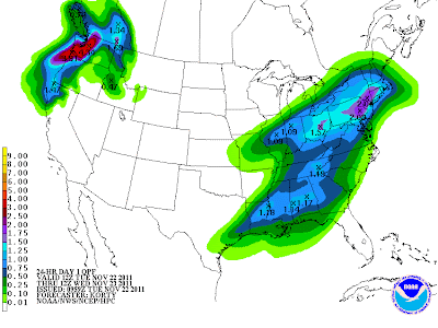
Speaking of rainfall, the latest HPC forecast (shown below) calls for widespread amounts of 1-2 inches across much of the same region. Localized amounts of 4-6 inches are possible in areas that receive repeat episodes of thunderstorm activity today and/or tonight:
Looking ahead to tomorrow and Thanksgiving Day, nothing has really changed since my update on Saturday, with rather uneventful weather instore for most of the country.
The upcoming weekend continues to look very active with a major change in the weather. There are likely to be significant travel concerns across a large part of the central and eastern U.S. this weekend and into early next week. Stay tuned for a detailed post on this later today...
If you enjoy reading 'The Original Weather Blog', please be sure to "like" our facebook page!


No comments:
Post a Comment