***An update to this outlook was made at 5pm on 11-13-11. Please go here to see the updated post.
------------------------------------------Original Post:
The weather pattern across North America and the U.S. is probably best described as "in transition" for the upcoming week. The main thing to keep an eye on appears to be the possibility of a sharp cold invasion toward the end of the week or next weekend across the Northwest & Northcentral U.S. (and where it will go beyond this forecast period - an excellent question that I can't really answer at this point in time, but more on that later).
Much of central and eastern Texas will see at least light rain from a disturbance on Monday, however the heavier and more widespread rains will pass by all but the extreme Eastern part of the state (an unfortunate but typical trend of the La Nina pattern that we're in).
Since most of the snow (locally heavy) associated with a disturbance currently moving into the central Rockies will take place tonight or early Sunday, it will not be addressed in this post. Watch for an individual post on this system later this morning.
Mountain snow and valley rain showers will continue across the Pacific Northwest for much of the week, growing stronger and more widespread by late in the week.
With the overview now covered, here are the particulars, starting with the temperature and precipitation trend maps for next week. I did not include a "Significant Weather Trends" map on this edition because they are sufficiently addressed by the maps below:
Southwest Rain Maker to Move Northeast:
A middle and upper-level weather disturbance, which originally dove into California from the Gulf of Alaska earlier in the week, will lift out East/Northeastward across the southern U.S. over the next few days. Middle and high level clouds are already streaming into Oklahoma and Texas ahead of this system, and light rain or showers will break out across much of central and east Texas by Monday as the system approaches.
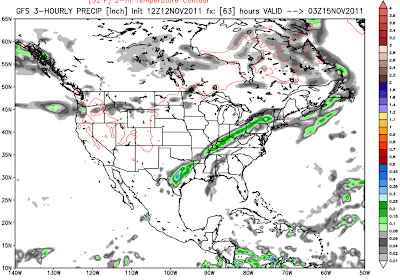
The series of images below shows how the GFS model is forecasting the rain to unfold across Texas (and the other affected states) at the indicated 3 hourly intervals on Monday:
3 Hour Rain Ending 3pm CST Monday
3 Hour Rain Ending 6pm CST Monday
3 Hour Rain Ending 9pm CST Monday
Coverage and intensity of the rain will increase in association with this disturbance as it moves out over the Mississippi and Tennessee Valley region, into the Ohio Valley by Tuesday, where localized amounts of 2 inches or more are possible:
3 Hour Rain Ending 9am CST Tuesday
3 Hour Rain Ending 12 Noon CST Tuesday
3 Hour Rain Ending 3pm CST Tuesday
3 Hour Rain Ending 6pm CST Tuesday
This will be a relatively fast moving system, with rain likely to end across the Northeast by early Wednesday.
Pacific Northwest Rain / Snow to Continue:
Mountain snow and valley rain showers will continue off and on throughout most of the week across the Pacific Northwest. Precipitation will increase in coverage and intensity from about Wednesday on, as indicated by the GFS running total precipitation forecast images shown below. The valid times are 6am CST (4am PST) Monday through Saturday, respectively (rainfall scale in inches on right hand side of images):
Precipitation will fall in the form of snow in the higher elevations, with the snow level decreasing by mid to late week as increasingly cold air moves in from the Northwest.
The latest run of the GFS model is forecasting well over 1 foot of new snow for the higher elevations of the Pacific Northwest and northern Rockies by 6am CST (4am PST) Thursday, as cold air and upper level energy increase across the region:
Polar Express to Make a Visit Late Week?
We've been monitoring trends over Alaska and western Canada for about a week or 10 days now, as very cold air has been building up over that region. Note the dark blue and purple shadings depicting temperatures of 10-20 degrees below normal (or even colder) across that region on the image below:
This cold air is very dense, and as a result it can only sit still in one place for a given period of time before it has to start making a move Southeastward with the jet stream. Well, it appears that is exactly what is going to take place late next week, as at least a piece of that very cold air is going finally make a move Southeastward.
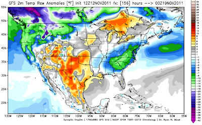
Note the Southeastward progression of much colder than normal air across the western, northwestern and northcentral U.S. (blue, green and purple shaded areas as indicated by the latest run of the GFS computer model) beginning 6pm CST Thursday, and continuing through Saturday:
Temperature Anomaly Valid 6pm CST Thursday
Temperature Anomaly Valid 6pm CST Friday
Temperature Anomaly Valid 6pm CST Saturday
You have probably also noticed the rapid build up of warmer than normal temperatures across much of the central and southern Plains during the same time period (orange, red and brown shaded areas on the same images above). This corresponds with an increasing ridge of high pressure that is forecast to develop across this region. At this time, it remains to be seen how much this ridge will be able to effectively block the cold air invasion and/or force it into the Northeast U.S. rather than down into the Plains late next weekend and into the following week (the week of Thanksgiving). We'll need to keep a close eye on the progression of the ridge (and how strong it becomes) during this time period so as to determine how much further South and/or East the cold blast is likely to progress in later days (i.e., Thanksgiving week).
Stay tuned to the blog for updates on this and the other weather makers throughout the coming week!
If you enjoy reading 'The Original Weather Blog', please be sure to "like" our facebook page!


No comments:
Post a Comment