Showing posts with label Weekly Medium Range Outlook. Show all posts

Saturday, November 19, 2011

Outlook for Thanksgiving 2011: Pretty Quiet for Most...

I figured I'd substitute the regular Weekly Outlook with a focus on Thanksgiving, and the big travel day on Wednesday. All in all, it will be a pretty quiet scene across much of the country the way it looks right now...

First, for Wednesday, it will continue to be wet across the Pacific Northwest, with mountain snows and valley rain showers, some of which could be heavy.

Meanwhile, a cool front and associated weather disturbance will be moving West to East out of the eastern Seaboard and New England, with lingering rain showers and some snow (North) ending during the day:


Most of the light green shaded area on the East coast won't see rain after 12 Noon on Wednesday, so that part of the map may look worse than it actually is...

The middle third of the country (and more) will see dry and relatively warm conditions.  The latest GFS temperature anomaly forecast valid 6pm CST on Wednesday forecasts readings of 15-20 degrees above normal across much of the northcentral Plains, and 10-15 degrees above normal across much of the central Plains:


Moving into Thanksgiving Day itself, it will be rather uneventful, weatherwise, across most of the Nation.  Valley rain and mountain snow showers will expand a bit in the West, with dry conditions for much of the remainder of the country.


Mild to warm conditions will continue across a good part of the Nation on Thanksgiving Day as well, with cooler than normal conditions continuing along the West Coast:


Stormy weather may develop yet again over the central and southern Plains into the Mississippi Valley by next weekend.  More on that in later posts...


If you enjoy reading 'The Original Weather Blog', please be sure to "like" our facebook page!


Sunday, November 13, 2011

Update on Weekly Outlook...

I don't normally make an "update" to the weekly outlook that I post on Saturday's, but rather make updated posts throughout the week on individual elements that were covered within the outlook.  I felt that an overall update was warranted in this case because 2 major facets of the outlook have undergone some rather dramatic shifts in the last 24 to 36 hours.


The first, and the most certain of the 2, has to do with the Texas through Northeast rain event in association with an upper level weather disturbance coming out of the Southwest.


The disturbance has slown by about 24 hours, and will not likely come out in full force until Monday night or early Tuesday.  The good news is that this will allow low-level moisture to build up over a larger portion of Texas, which could result in heavier rain further Southwest than earlier forecast.  


The latest run of the GFS model accumulated precipitation forecast is shown below:


As you can see, the model is now forecasting 1 inch or more of rain (1 inch begins with the lightest blue shading, as per the scale on the right hand side of the image) from portions of westcentral and northwest Texas on to the Northeast.

So, when it has to do with this early to mid week rain event, you can push the timing aspects that were covered in the original weekly outlook out about 24 hours, and everything else will hold in place (other than the potential for more generous rain further West in Texas - which would certainly be welcome).

Stay tuned for another detailed update on this rain event, particularly having to do with Texas, on Monday.

Now, on to the less certain portion of the update - which deals with the movement of cold air into the U.S. this week.

The last few model runs have indicated that at least a piece of the cold air we talked about in the weekly outlook will break loose earlier than expected, and potentially make a run even further South than earlier expected (although I did point out that we would need to keep an eye on that part of the forecast).

Take, for example, the latest GFS model forecast of the departure from normal temperatures valid at 6pm CST for the period Monday through Thursday of this week (watch the progression of the cold air - blue and green shaded area from Southwest Canada into the U.S. during the period):


If the above forecast verifies, then colder air (though not the coldest of the cold - see further below) will sweep Southward much earlier than originally expected, possibly reaching the central Plains of Kansas and Oklahoma as early as Tuesday night or early Wednesday.

Granted, this is not the coldest of the cold air that we originally talked about, and the models still project that even colder air will move into the U.S. beyond this next weekend, into the week of Thanksgiving, but this will be cold enough to feel the difference (and some 15 degrees or more below normal in many areas).

Is this just a computer model "flip-flop", or is this the real deal?  Time will tell, but as I pointed out in the original post, cold air this dense and heavy can only hold on in one place for so long.  It appears that the models are coming around, rather abruptly, on just how long a period of time that will be, with at least a piece of it being forecast to break loose rather quickly this week.

Watch for another more detailed update on this situation on Monday as well...


If you enjoy reading 'The Original Weather Blog', please be sure to "like" our facebook page!

Saturday, November 12, 2011

Outlook for Next Week: Watching for Possible Cold Invasion Late Week...

***An update to this outlook was made at 5pm on 11-13-11. Please go here to see the updated post.


------------------------------------------Original Post:


The weather pattern across North America and the U.S. is probably best described as "in transition" for the upcoming week. The main thing to keep an eye on appears to be the possibility of a sharp cold invasion toward the end of the week or next weekend across the Northwest & Northcentral U.S. (and where it will go beyond this forecast period - an excellent question that I can't really answer at this point in time, but more on that later).


Much of central and eastern Texas will see at least light rain from a disturbance on Monday, however the heavier and more widespread rains will pass by all but the extreme Eastern part of the state (an unfortunate but typical trend of the La Nina pattern that we're in).


Since most of the snow (locally heavy) associated with a disturbance currently moving into the central Rockies will take place tonight or early Sunday, it will not be addressed in this post.  Watch for an individual post on this system later this morning.


Mountain snow and valley rain showers will continue across the Pacific Northwest for much of the week, growing stronger and more widespread by late in the week.


With the overview now covered, here are the particulars, starting with the temperature and precipitation trend maps for next week.  I did not include a "Significant Weather Trends" map on this edition because they are sufficiently addressed by the maps below:


Southwest Rain Maker to Move Northeast:

A middle and upper-level weather disturbance, which originally dove into California from the Gulf of Alaska earlier in the week, will lift out East/Northeastward across the southern U.S. over the next few days.  Middle and high level clouds are already streaming into Oklahoma and Texas ahead of this system, and light rain or showers will break out across much of central and east Texas by Monday as the system approaches.

The series of images below shows how the GFS model is forecasting the rain to unfold across Texas (and the other affected states) at the indicated 3 hourly intervals on Monday:

3 Hour Rain Ending 3pm CST Monday

3 Hour Rain Ending 6pm CST Monday

3 Hour Rain Ending 9pm CST Monday


Coverage and intensity of the rain will increase in association with this disturbance as it moves out over the Mississippi and Tennessee Valley region, into the Ohio Valley by Tuesday, where localized amounts of 2 inches or more are possible:

3 Hour Rain Ending 9am CST Tuesday

3 Hour Rain Ending 12 Noon CST Tuesday

3 Hour Rain Ending 3pm CST Tuesday

3 Hour Rain Ending 6pm CST Tuesday

This will be a relatively fast moving system, with rain likely to end across the Northeast by early Wednesday.


Pacific Northwest Rain / Snow to Continue:

Mountain snow and valley rain showers will continue off and on throughout most of the week across the Pacific Northwest.  Precipitation will increase in coverage and intensity from about Wednesday on, as indicated by the GFS running total precipitation forecast images shown below.  The valid times are 6am CST (4am PST) Monday through Saturday, respectively (rainfall scale in inches on right hand side of images):


Precipitation will fall in the form of snow in the higher elevations, with the snow level decreasing by mid to late week as increasingly cold air moves in from the Northwest.  

The latest run of the GFS model is forecasting well over 1 foot of new snow for the higher elevations of the Pacific Northwest and northern Rockies by 6am CST (4am PST) Thursday, as cold air and upper level energy increase across the region:


Polar Express to Make a Visit Late Week?

We've been monitoring trends over Alaska and western Canada for about a week or 10 days now, as very cold air has been building up over that region.  Note the dark blue and purple shadings depicting temperatures of 10-20 degrees below normal (or even colder) across that region on the image below:


This cold air is very dense, and as a result it can only sit still in one place for a given period of time before it has to start making a move Southeastward with the jet stream.  Well, it appears that is exactly what is going to take place late next week, as at least a piece of that very cold air is going finally make a move Southeastward.

Note the Southeastward progression of much colder than normal air across the western, northwestern and northcentral U.S. (blue, green and purple shaded areas as indicated by the latest run of the GFS computer model) beginning 6pm CST Thursday, and continuing through Saturday:

Temperature Anomaly Valid 6pm CST Thursday

Temperature Anomaly Valid 6pm CST Friday

Temperature Anomaly Valid 6pm CST Saturday


You have probably also noticed the rapid build up of warmer than normal temperatures across much of the central and southern Plains during the same time period (orange, red and brown shaded areas on the same images above).  This corresponds with an increasing ridge of high pressure that is forecast to develop across this region.  At this time, it remains to be seen how much this ridge will be able to effectively block the cold air invasion and/or force it into the Northeast U.S. rather than down into the Plains late next weekend and into the following week (the week of Thanksgiving).  We'll need to keep a close eye on the progression of the ridge (and how strong it becomes) during this time period so as to determine how much further South and/or East the cold blast is likely to progress in later days (i.e., Thanksgiving week).

Stay tuned to the blog for updates on this and the other weather makers throughout the coming week!


If you enjoy reading 'The Original Weather Blog', please be sure to "like" our facebook page!

Saturday, November 5, 2011

Outlook for Next Week; Severe Weather 1st Half in South / MS Valley...

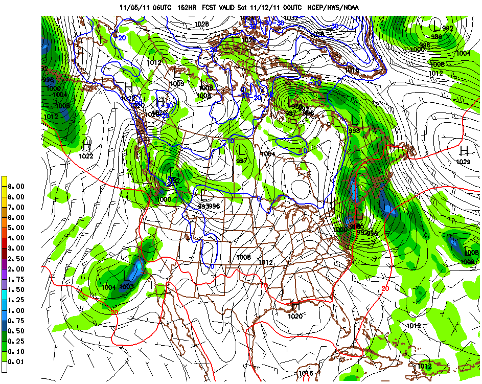
There will be several areas of active weather next week, with all types of elements involved (from spring-like storms to snow). Of greatest concern at this time is the threat of severe storms, including tornadoes, across portions of the Southern and Central Plains on Monday, the Mississippi Valley on Tuesday, and the Deep South by Wednesday:


The severe storms will also bring widespread rainfall amounts of 1 inch or more to a significant portion of the middle third of the country.  This locally heavy rain threat will spread into New England by the end of the week.  Meanwhile, the first measurable snow of the season appears likely in a relatively narrow band from northwest Kansas into the Upper Peninsula of Michigan on Tuesday and Wednesday:


Temperature wise, it will generally be cooler than normal in the Great West, with fluctuating temperatures (from warm to cooler to warm again) in the central and eastern two thirds of the nation throughout the week:


Severe Weather Threat South for the First Half of Week:

A relatively strong area of surface low pressure will interact with a very strong middle and upper level weather disturbance and strong jet stream winds to produce a significant threat of severe weather (for this time of year) during the period Monday through Wednesday.

The images below are the latest GFS model surface forecasts valid 6pm CST on Monday, Tuesday and Wednesday:

GFS Surface Map Valid 6pm CST Monday

GFS Surface Map Valid 6pm CST Tuesday

GFS Surface Map Valid 6pm CST Wednesday

I've drawn the applicable fronts on the images.  As you can see, a surface cold front and low pressure center will move from the southern and central Plains on Monday into the Mississippi Valley on Tuesday and the Deep South on Wednesday.  Meanwhile, in the middle and upper levels of the atmosphere, a band of strong winds and rapidly rising air will overspread the same regions at about the same times, which will result in a threat of severe weather.

GFS Mid-Level Wind Forecast Valid 6pm CST Monday

GFS Mid-Level Wind Forecast Valid 6pm CST Tuesday

GFS Mid-Level Wind Forecast Valid 6pm CST Wednesday

Large hail, damaging winds and some tornadoes are all likely in association with this activity.  At this time, it appears that Monday will have the highest severe weather threat, followed by Tuesday, and to a lesser extent on Wednesday.  Please see the Significant Weather Trends map at the top of this post for the specific severe weather threat areas by day.

Residents across these areas should remain alert and listen for later updates and forecasts.  Review severe weather safety tips and be prepared to seek shelter if threatening weather approaches your area.

The activity will also produce some much needed rain across portions of the middle third of the nation.  The GFS models total rainfall accumulation forecast is shown below, which indicates widespread 1 inch or greater rainfall within the blue and red shaded areas on the image:


Unfortunately, other than the Red River areas of North Texas, it does not appear as though widespread significant rains will take place across much of the remainder of the drought stricken Lone Star State.  A few folks in central or south Texas may get lucky enough to get underneath an isolated thunderstorm on Monday evening that could produce a locally heavy downpour, but this does not appear to be a widespread event at this time for that part of the region.

As the system progresses further East later in the week, widespread locally heavy rains are forecast across portions of the Northeast, especially New England, by Thursday and into Saturday.  This event may end as snow, some of which could be locally heavy, across interior New England late Friday or early Saturday.  See the winter weather discussion for more details on this.

Winter Weather Potential for Next Week - First Measurable Plains Snow:

As the system described above moves Eastward, colder air will filter down in the wake of the cold front, changing precipitation from rain to snow in a relatively narrow band from northwest Kansas into Wisconsin and the U.P. of Michigan on Tuesday and Wednesday. 

The latest GFS snowfall forecast is suggesting a band of 1-3 inch snow, with locally higher amounts, across this general swath:


As the system progresses into the Northeast toward the weekend, locally heavy snow is indicated across portions of interior New England, especially Vermont and New Hampshire, where the GFS model is currently forecasting 6 inches plus of snow in some spots late Friday into early Saturday:


Stormy Weather for Southern California / Southwest Late Week:

A relatively strong area of low pressure, accompanied by an upper-level weather disturbance, is forecast to invade the Southwest late in the week, bringing windy and wet weather first to Southern California by Friday, then progressing across the Southwest into the weekend.

Below are the latest GFS forecast model images valid 6pm CST on Friday and Saturday:

GFS Surface Forecast Valid 6pm CST Friday

GFS Surface Forecast Valid 6pm CST Saturday

This system will produce locally heavy rainfall across much of the region late in the week:


Please check back to the blog throughout the coming week for updates on these and other developing weather events...

Time Change Reminder:

Finally, just a friendly reminder to make sure that your clocks "Fall Back" on Sunday morning, as Daylight Savings Time ends!


If you enjoy reading 'The Original Weather Blog', please be sure to "like" our facebook page!

Sunday, October 30, 2011

Outlook for This Week: Quiet East / More Active West...

This will be an abbreviated weekly outlook compared to normal, and I apologize for not getting this posted yesterday as I customarily would (I was busy with the Northeast storm and some other things that were going on...)


In summary, we're trending toward a quieter time in the East and a more active time in parts of the West (and North) this week.


A ridge of high pressure will build into the East during the week, as a trough is gradually carved out West:


This will result in above normal precipitation across the Pacific Northwest, primarily from a storm that is expected to impact the region late Wednesday through Friday.  The latest run of the GFS computer model is forecasting rainfall amounts in excess of 2 inches in many areas, as indicated by the red shaded regions on the image below:


This will also equate to locally heavy snows in the higher elevations of the Cascades by the end of the work week:


The Western trough will eject a piece of energy into the central Plains and Midwest by late Wednesday and into Thursday, which will give a shot of precipitation to that region as well.  At this time it appears that it will be of little benefit to drought stricken Texas as a whole, as shown by the GFS model rainfall forecast image below (scale in inches shown on the right):


This system will bring another round of snow to the Rockies at mid-week as well - almost exactly 1 week after the first significant event of the season in this region!  Below is the latest GFS snowfall forecast centered on the Denver area.  Most of the snow indicated on this image would fall late on Tuesday or on Wednesday (scale in inches at bottom of image):


Another popular U.S. computer forecast model, the NAM, is less aggressive in the Front Range and Foothills region (including Denver), but still forecasts accumulating snow on Wednesday:


I think accumulating snow is a safe bet for the region at mid-week, the main question at this point is just how much.  Stay tuned for updates on that on Monday, as we ought to  have a much better idea.


If you enjoy reading 'The Original Weather Blog', please be sure to "like" our facebook page!