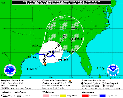
Tropical Storm Lee has now formed in the Gulf. At 4pm CDT, the center of Lee was located 220 miles Southeast of Port Arthur, TX and drifting Northward at 2 mph. Maximum sustained winds were 45 mph and the minimum barometric pressure was 29.62 inches of mercury (1003 millibars).
As I mentioned yesterday and earlier this morning, the main threat with Lee will be torrential, flooding rains. He is forecast to meander generally Northward over the next few days, before moving inland over southeast Louisiana on Sunday.
Widespread rains of 10-15 inches with local amounts near 20 inches can be expected along and near the immediate path of Lee through Sunday. Heavier rains will spread Northeastward into parts of the Southeast and Mid-Atlantic by the first of next week. The rainfall forecast below is valid 7pm CDT today through 7pm CDT Monday:
Unfortunately, as we indicated yesterday, the expected track of Lee will not bring any major relief (in the form of rain) to the drought in Texas. Cooler air will still flow into the region by Labor Day, but rainfall ahead of the cold front will be sparse compared to the widespread rains associated with Lee.
If you enjoy reading 'The Original Weather Blog', please be sure to "like" our facebook page!


No comments:
Post a Comment