As mentioned in a post on Saturday, a strong cold front is forecast to drive Southward into much of the Northern and Central Plains, Midwest and Great Lakes region later this week, which will bring the threat of the first widespread frost and/or freeze of the season to parts of the region.
The cold blast will initially begin across the Dakotas, with a light freeze and frost possible early Wednesday morning. The latest GFS computer model forecast, valid 7am CDT Wednesday is shown below:
By 24 hours later, the cold air will advance even further South and Eastward. The same GFS computer model forecast, this time valid at 7am CDT on Thursday morning, is shown below:


The cold blast will initially begin across the Dakotas, with a light freeze and frost possible early Wednesday morning. The latest GFS computer model forecast, valid 7am CDT Wednesday is shown below:

I've drawn the cold front with the thick blue line, and you can see the area outlined with the thinner blue line behind the front (across much of Canada and nosing into North Dakota). That's where the model is forecasting a temperature of freezing or below at that time. It will still be quite windy on Wednesday morning, even in North Dakota, so that will tend to limit the potential for frost build-up, but some areas may dip just below the freezing mark by dawn near the Canadian border.
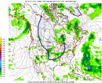
By 24 hours later, the cold air will advance even further South and Eastward. The same GFS computer model forecast, this time valid at 7am CDT on Thursday morning, is shown below:

Once again, the area outlined by the thinner blue line denotes where the computer model is forecasting temperatures to be at or below freezing at that time. As you can see, this includes much of Minnesota, as well as adjacent portions of northern Iowa and the far eastern Dakotas as well as northwest Wisconsin.
A larger area of potential frost can be expected across much of Minnesota, northern and central Iowa, eastern Nebraska, the far Eastern portions of the Dakotas and western into central Wisconsin (where the surface winds are forecast to be lighter early on Thursday morning).
The threat of a frost and/or localized freeze will shift Eastward into much of the Great Lakes region on Friday morning:

Also, notice how Tropical Storm (or Hurricane) Maria is forecast to become absorbed by the cold front several hundred miles off of the New England Coast on Friday morning...
Further South, while temperatures will be cooler behind the front, the main story will come in the form of widespread rain from southeast Colorado and northeast New Mexico, Eastward across the Texas Panhandle, southern Kansas and much of Oklahoma into Arkansas and southern Missouri. The image below shows the GFS model's total precipitation forecast for Wednesday through Friday:

Within the red and purple shaded areas across southeast Coloroado and northeast New Mexico, localized rains of 2-4 inches are possible. A fairly widespread swath of 0.5 to 1 inch of rain is forecast across much of the remainder of the aforementioned region, with locally higher amounts possible again over Arkansas and southern Missouri.
Unfortunately, at this time it does not look as though significant rain will get much further South than the Panhandle or perhaps the Red River region in Texas with this particular front (although this is certainly good news for the panhandle region and western Oklahoma).
Looking further ahead, the GFS model does signal some hope for rain across the main body of Texas next week, in association with another cold front that is forecast to track across the region during the Tuesday-Wednesday time frame, as shown on the image below (valid 7pm CDT Tuesday, 9-20-11):

Unfortunately at this time it looks like the front will be moving rather quickly, which will tend to limit precipitation amounts at any given location to less than 1 inch (probably more like 0.25-0.50 inch), but at this point we'll obviously take whatever we can get!
This particular front will also bring cooler temperatures further South into Texas as compared to the one later this week...
If you enjoy reading 'The Original Weather Blog', please be sure to "like" our facebook page!
No comments:
Post a Comment