Showing posts with label 2011 Drought. Show all posts

Sunday, October 14, 2012

Austin, TX Rainfall: What a Difference a Year Makes!

As the old saying goes, "a picture speaks a thousand words...", so I'll let the following do the work:

Austin, TX Total Rainfall for 2011 thru October 12th:  10.00 Inches


Austin, TX Total Rainfall for 2012 thru October 12th:  33.96 Inches


For more information from 'The Original Weather Blog', including shorter, more frequent posts during rapidly changing weather events, please be sure to follow Rob on facebook and twitter:
 

If you are in need of customized, site specific weather forecasts or storm warnings for your company or event, be sure visit Rob's professional webpage at WeatherGuidance.com.


Monday, December 26, 2011

#2 Weather Disaster of 2011: Southern and Southwest U.S. Drought


With total property and crop losses exceeding $10 billion, the severe drought and heatwave of the spring and summer (and drought continuing into the fall) across the Southern Plains and Southwest U.S. comes in at #2 on the list of billion dollar weather disasters of 2011.


With late winter and early spring rains lacking, the drought was already getting underway across much of Texas and New Mexico by mid-March:


...and would only worsen throughout the summer.  By August 30, extreme to exceptional drought conditions were present across much of the southern Plains and southwest U.S.:


Through December 26, 2011, much of central and eastern Texas still faces a  rainfall deficit of some 15-20 inches for the year, with much of New Mexico facing a deficit of 6-12 inches (note, the deficit is actually larger in some places that saw below normal values of rainfall toward the end of 2010):

Departure From Normal Rainfall for 1/1/11 - 12/26/11

The extreme drought took a heavy toll on livestock and crops across the South.  Not only did ranchers face drought on their own properties, but the widespread nature of the event caused hay and other livestock related feed prices to skyrocket.  Add the increased transportation costs to the mix (to bring feed and other resources in from areas that were not experiencing drought), and it put some family ranchers out of the cattle business altogether.


In Texas alone, drought related losses to livestock are estimated at $2.1 billion.  


Many may not have realized it, but the drought started to affect the pocketbooks of Americans by late summer and early fall, via increasing costs at the grocery store.  In Texas, the peanut crop was particularly hard hit by the drought, which resulted in a dramatic increase in cost in everything from peanut butter to mixed nuts across the country by the fall.

Other crops that took a hit from the hot and dry weather in Texas included wheat (estimated loss of $243 million) and corn (estimated loss of $327 million).


The cotton crop was the hardest hit of all, at an estimated $1.3 billion in Texas alone.


The American Farm Bureau estimated that Thanksgiving dinner cost Americans 13% more to prepare on average this year, compared to 2010 (a similar figure is being cited for your Christmas meal as well).  Among other things, beef prices are up 10-15% and poultry prices are up 15-20% on average (compared to one year ago).

Beneficial rains have fallen across much of the Northeastern portions of the region over the last 30 days:

Departure From Normal Rainfall for 12/1/11 - 12/26/11

...however extreme to exceptional drought conditions remain firmly in place across the majority of southern, central and western Texas into New Mexico and Arizona.  That trend is forecast to continue so for the foreseeable future:


...which will spell a continuation of further economic losses and strong pressure on food prices into at least the first half of 2012.


Editorial note:  The Texas and Southwest U.S. wildfires were not factored into the drought assessment.  When tabulating the list of billion dollar weather disasters of 2011, NOAA classified the wildfires separately.  With $1 billion in associated property losses so far, the Texas and Southwest wildfires of 2011 currently rank in the #12 spot on the list of billion dollar weather disasters of 2011.


If you enjoy reading 'The Original Weather Blog', please be sure to "like" our facebook page!

Thursday, December 15, 2011

Central/Southern Plains Rainfall Update...


As you can see on the above radar image, rainfall is widespread from central and eastern Texas into the middle Mississippi Valley at this hour.

The image below shows rainfall totals as of 6am CST this morning (scale in inches on the right):


Additional rainfall, some locally heavy, has taken place today and will continue into tonight.  


The series of images below show the HPC's rainfall forecast at 24 hour intervals.  The first is from 6pm CST today through 6pm CST Friday:


The rainfall is forecast to lessen and shift Southward for the period 6pm CST Friday through 6pm CST Saturday:


...and 6pm CST Saturday through 6pm CST Sunday:


...and will increase in coverage and dramatically increase in intensity for the 2 day period from 6pm CST Sunday through 6pm CST Tuesday:


Stay tuned for a more detailed post regarding the Monday and Tuesday storm system (as alluded to on the last image above)...


If you enjoy reading 'The Original Weather Blog', please be sure to "like" our facebook page!

Tuesday, December 13, 2011

Severe Weather / Much Needed Rain Possible In Parts of Central TX on Wednesday...


Above is the latest Severe Weather Outlook for Wednesday afternoon and evening, via the SPC in Norman, OK. Severe thunderstorms are forecast within the yellow shaded area on the image, which includes the I-35 Corridor from San Antonio and Austin through Waco and the DFW Metroplex.

An upper-level weather disturbance is forecast to lift across the severe weather outlook area on Wednesday afternoon and evening.  This will spark scattered strong thunderstorms, some of which may become severe and produce large hail and damaging wind gusts.  An isolated tornado also cannot be ruled out, particularly with any storms that are able to become well organized and remain rather isolated from surrounding activity.

Some thunderstorm activity is likely to already be underway at sunrise on Wednesday over southwest Oklahoma and northwest Texas.  Some of these storms may produce hail to near severe limits even during the morning hours.

Meanwhile widespread shower activity with embedded thunderstorms will produce more badly needed rain across the Lone Star state, Northward into Oklahoma tonight and into tomorrow:


Unfortunately, as you can see, the heaviest and most widespread precipitation will take place in areas that don't really need it, such as the upper Mississippi Valley and Midwest.

This, however, is just the first of several disturbances that will affect Texas throughout the remainder of this week.  For the period 6am CST today through 6am CST Sunday, total rainfall potential will exceed 1 inch across most of central and eastern Texas, Northward:


If you enjoy reading 'The Original Weather Blog', please be sure to "like" our facebook page!

Saturday, December 3, 2011

Meanwhile, Out in the Warm Sector, the Rain Continues...


The large storm system affecting the Rockies and Plains is about more than just winter weather. As we've been talking about for several days now, widespread rain, some heavy, will take place in the "warm sector" of the storm over the next few days.  (The warm sector describes the area that will remain above freezing, with precipitation forecast to fall entirely in the form of rain).

The latest 5 day rainfall forecast from the HPC is shown below:


As you can see, a large area of 3-6 inch rainfall continues to be forecast from extreme northeast Texas across central and eastern Arkansas and on into the mid-Mississippi valley region.  Locally higher amounts in excess of 6 inches are possible, particularly across the brighter orange shaded area.

Here is how the daily rainfall forecast looks for each of the next 5 days:

Saturday

Sunday

Monday

Tuesday-Wednesday


While the rain is good news for drought stricken areas, the heaviest of the precipitation (as is typical with the type of pattern that we're in this winter) will fall across areas that do not really need it.  Flood and Flash Flood Watches (an in some cases, warnings) are already in effect across portions of this region:


In addition, river flooding is already in progress or forecast for many areas:


...and I would expect additional watches and warnings related to flooding and flash flooding to be issued over the course of the next few days...

Remember, never drive across a roadway that is covered in water - no matter how shallow the water appears to be.  Flash flooding can be especially dangerous at night, so use extreme caution if nighttime travel is required in a flood or flash flood watch area.


If you enjoy reading 'The Original Weather Blog', please be sure to "like" our facebook page!

Friday, December 2, 2011

Update on the "Rainy Side" of the Winter Storm System...

Rain will develop and increase across the southern Plains, Deep South, middle Mississippi Valley and Tennesee Valley region in association with the strong surface cold front and upper-level low pressure system that we've been talking about for the past several days.


Light showers are already breaking out in central Texas this morning and will increase in areal coverage and intensity over the weekend:


The latest 5 day rainfall forecast from the HPC is shown below:


...which is in very close agreement with the GFS computer model forecast for the same time period:


As you can see, widespread heavy rainfall of 4-6 inches, with locally heavier amounts, are forecast across a swath extending from northeast Texas across Arkansas and into the middle Mississippi Valley region.

Here is how the rainfall is forecast to break-out by day:

Friday

Saturday

Sunday

Monday-Tuesday

While it is certainly good news to see additional rains across Texas, for example, the severe drought continues.  As has been the case so far this fall and winter, the heaviest of the rain will take place outside of the most severely drought stricken regions (with the exception of far northeast Texas) as you can see on the map below:


Unfortunately, this trend is likely to continue under the La Nina type pattern that we're in...but at least we can hopefully get some periods of even light to moderate rain from time to time to prevent the drought from becoming even worse than it already is.


If you enjoy reading 'The Original Weather Blog', please be sure to "like" our facebook page!

Monday, October 17, 2011

Massive Dust Storm in Lubbock, TX Area...


Sometimes right before sunset you can pick out some things on visible satellite imagery that you can't always see as clearly during broad daylight (due to the angle of the sun, ground temperatures, etc).  The visible image that I just took a snapshot of above is one such example.

Look at the tips of the yellow arrows over east-central New Mexico and west-central Texas.  The grayish-white behind the arrow tips is the leading edge of a wall of dust that is advancing Southward, immediately behind the cold front.    Gusty N-NW winds of 40-50 mph are driving the dust cloud...which will continue to spread Southward across the region during the next couple of hours.

The image below was taken outside of the NWS office in Lubbock, showing the large wall of dust advancing toward the complex:


An impressive video was also posted by a homeowner in a residential area as the massive wall of dust was approaching the subdivision:


With the record setting drought continuing across the region, there is little wonder why a front like this has plenty of dust to pick up.  I have a feeling we'll be seeing scenes like this time and time again this fall and winter across west Texas and eastern New Mexico.


If you enjoy reading 'The Original Weather Blog', please be sure to "like" our facebook page!

Thursday, October 13, 2011

The Latest Casualty of the Drought - Peanut Butter...


If you've got any "PB and J" lovers in your house and have some extra pantry space, you might want to stock up on the creamy stuff now (or the crunchy variety, if you prefer) - before a drought-related price jump takes place in the very near future...

The peanut crop is rapidly becoming the latest casualty in the ongoing southern U.S. drought.  Supplies are diminishing and a rather dramatic ramp-up of wholesale prices for everything from peanut butter to mixed nuts is about to take place as a result.


Extreme to excessive drought conditions continue across a large portion of the southern U.S., as depicted by the red, orange and brown shaded regions on the image below:


...unfortunately for peanut lovers, the hardest hit area corresponds almost perfectly with the prime real estate for peanut production:


With the drought already well underway earlier this spring, many farmers planted cotton (a more drought tolerant crop) rather than take a risk on the drought breaking.  This, along with what crops were planted suffering from extreme heat and lack of rain have resulted in a shortage of peanuts in the U.S.  Only 38% of the U.S. peanut crop was rated "good" or "excellent" last month, which is down from about 60% at the same time last year.  


According to this article in the Wall Street Journal (subscription may be required), Jif has announced a 30% increase in wholesale peanut butter prices beginning in November and Peter Pan has announced a 24% increase "in a couple weeks".  Kraft has announced a planned 40% increase in prices for its "Planters" brand on October 31st.  You can expect that a good chunk (no pun intended) of the increases will be passed along to consumers.

In fact, many analysts are warning that we should not be shocked to see a standard size jar of peanut butter rise above $4.00 by year end...


If you enjoy reading 'The Original Weather Blog', please be sure to "like" our facebook page!

Sunday, October 9, 2011

Much Needed Rain Along I-35 Corridor - But Not a "Drought Buster"...


Above is the storm total rainfall estimate from the New Braunfels, TX doppler radar. I've zoomed in to the San Antonio-Austin corridor along I-35, which is located near the middle of the screen.  The widespread yellow shaded areas indicate 1.5-2.5 inch rains, while I've noted the 3" plus rains in the darker red and purple shaded areas.

The radar does generally well estimating rainfall in the widespread type event that we saw overnight.  As an example, my home is located at the tip of the red arrow on the zoomed-in image below:


The radar estimated right at 1.0 inch of rain for my location, and the rain gauge (as noted in black) showed 1.25 inches at 9am this morning.  Not a bad estimate on the radar's part...

While the rains are certainly welcome...they were no where near a drought buster.  It would take a month or more of rain like this every single day in order to break the extreme drought conditions that are in place across the region.

There will be an opportunity for additional rains later today.  We'll have to see how much the atmosphere was "worked over" by the overnight event and what impact that may have on redevelopment later today.


If you enjoy reading 'The Original Weather Blog', please be sure to "like" our facebook page!

Saturday, October 8, 2011

Update on Weekend Rains in the Plains...

A broad swath of much needed rainfall, some heavy, continues to advance very slowly Eastward across the High Plains region this morning, as shown by the latest radar mosaic below:


The heaviest rainfall today, on the order of 4-6 inches locally, is expected to take place in a swath from northwest and westcentral Oklahoma into northwest and westcentral Texas, as shown on the image below (valid 7am CDT today through 7am CDT Sunday):


Here is how the rainfall is forecast to break out throughout the day today, first during the period 7am-1pm CDT:

...from 1pm-7pm CDT:

...and from 7pm (today) to 1am CDT (Sunday):

The forecast for tomorrow looks much the same as today, with some southeastward progression of the rain into southcentral or southeast Texas.  Widespread 3-5 inch amounts are forecast again from western Oklahoma into westcentral Texas:


By Monday, the intensity is forecast to have lessened, with a bit more of an Eastward progression as well:

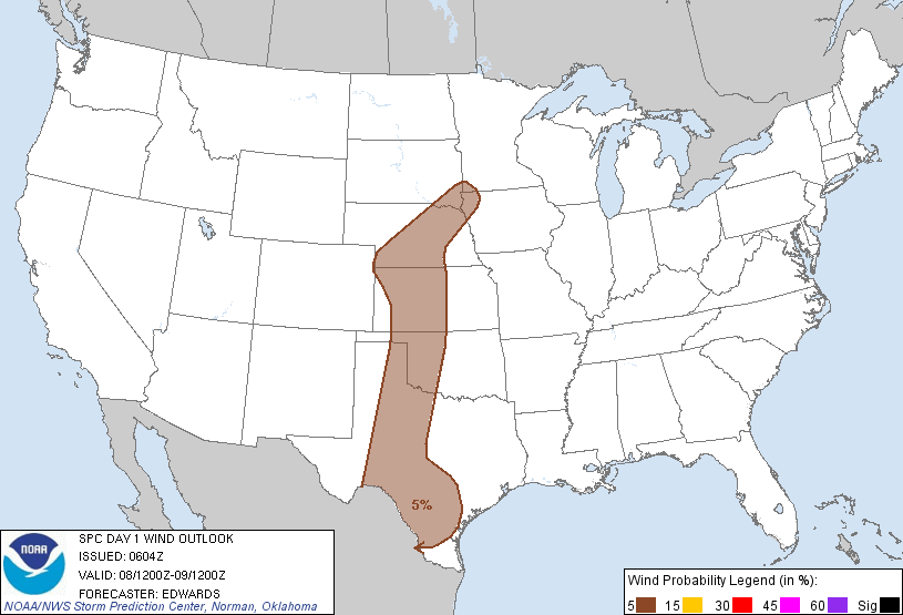
Some of the storms are likely to approach severe limits this afternoon and evening across the High Plains.  The greatest threats would be wind gusts and hail to near severe limits in the area shown in brown on the image below (from the SPC):


If you enjoy reading 'The Original Weather Blog', please be sure to "like" our facebook page!