
At 8:30 a.m. CDT, the center of Tropical Storm Lee was located just South/Southeast of the New Iberia airport in southcentral Louisiana. I've circled the center in red on the same radar image below just in case you can't make that out:

As shown on the graph below, the barometric pressure at the New Iberia airport has been dropping steadily...and now rests at 29.15 inches of mercury:

Rainfall has also been increasing at the same location (bottom half of the above chart). The red bars show the hourly rainfall rates - currently approaching 1 inch at the airport.
Sustained winds of 35-45 mph, with gusts to 55 mph continue to be reported, mainly on the Eastern side of Lee. The winds will steadily decrease now that the center of Lee is moving further inland, however gusts of 40-50 mph can be expected in stronger squalls through this morning.
As has been the case all along, the biggest story with Lee will continue to be torrential rainfall. The image below is the Storm Total Rainfall Estimate from the doppler radar located near New Orleans:

The pink shaded areas show where the radar estimates an average of 7-8 inches of rain has fallen. The lavender shaded areas average 8.0-9.5 inches, and the spotty white areas show where the radar is estimating 10-10.5 inches of rain - so far.
Ever wonder just how accurate the radar rainfall estimation is? Just to give an example, the highest 24 hour rainfall total that I could find on the airport observing stations (again for emphasis, airport observing stations - not all observing stations) was 7.17 inches at the Pascagoula airport in Mississippi (see table below):

I have noted the location of the airport on the same radar rainfall estimate image below, using a white arrow (look toward the right center portion of the image):

If you hover over the airport location, the radar estimates that 6.93 inches of rain has fallen there. Pretty darn close to 7.17 if you ask me! Now granted, I have not "quality controlled" the remainder of the above reports, but needless to say, the radar precipitation estimate is certainly giving us a good idea as to what is actually happening on the ground.
Torrential rains will continue spreading slowly Northeastward today, then more rapidly tonight and into early next week. Below is the latest total precipitation forecast for today, Monday and Tuesday:

As you can see, widespread amounts of 6-8 inches, with localized amounts near 10 inches are forecast across a large part of the southeast and into the Tennessee Valley, Appalachians and mid-Atlantic region. This will be falling on top of already rain soaked grounds from Irene in many areas, which will lead to an even greater threat of flash flooding and river/stream flooding.
Here is how the rainfall forecast is broken down by day, starting with today:

...and Labor Day Monday:

...and Tuesday:

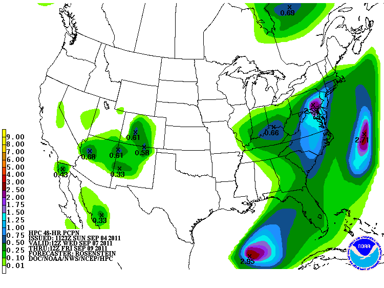
As you can see, the greatest potential impact to areas affected by Irene last week will take place beginning Tuesday. By the period Wednesday through Friday, heavy rains are forecast to advance up into New England as well:
With many rivers still in flood across the region after Irene, it is critical that folks from the Mid-Atlantic on Northward pay very close attention to later forecasts involving the latest round of heavy rains from Lee. Meanwhile, folks back to the South will continue dealing with heavy, potentially flooding rains from Lee today through Labor Day.
Isolated tornadoes will also continue to be a threat with Lee today, particularly in association with stronger squalls to the "right" (East) of the center. The SPC has issued a Tornado Watch for much of this region valid until 4pm CDT today:

If you enjoy reading 'The Original Weather Blog', please be sure to "like" our facebook page!
No comments:
Post a Comment