The damage to Mapleton, IA from a large tornado on Saturday April 9th was extensive (and that may be an understatement). Over 60% of the town was completely destroyed. In a testament, however, to the severe weather watch and warning program, there were no deaths and only 10-15 minor injuries (worst was a broken leg).
Below is a map showing the raw tornado reports as they were initially received yesterday evening. Any additional remarks are located within the blue text boxes pinned near the tornado touchdown sites:


Below are some photos captured on a cellphone as the tornado approached Mapleton (via Twitter):


Below is a map showing the raw tornado reports as they were initially received yesterday evening. Any additional remarks are located within the blue text boxes pinned near the tornado touchdown sites:

The NWS in Omaha has completed their survey of the damage, and have assessed the maximum intensity of the tornado at EF-3. Below is their track and damage map of the immediate Mapleton area:

Based on the survey results, the tornado was three-quarters of a mile wide at its greatest width, and remained on the ground for approximately 3.5 miles.


And here is a video (via YouTube) of the large, wedge tornado (time unknown). The video takers are not identified, but they are way, way too close to the tornado in the beginning of this video (flying debris alone can kill you at this close distance):
This next YouTube video was taken at a much safer distance, and appears to show the tornado at an earlier time before it became a "wedge". It is unclear what location this was taken in reference to Mapleton, but based on scenery and lighting I'd have to say this was taken just prior to the tornado reaching town:
This third YouTube video appears to show the tornado when it was first developing, approximately 2 miles South of Mapleton on County Road L32 (per the description from the video taker). You can hear NOAA Weather Radio chattering away in the background:
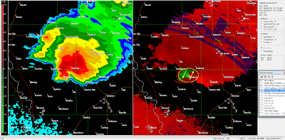
Below is an image taken from the Omaha doppler radar just as the tornado was plowing through Mapleton. The left half of the image show the radar in reflectivity mode (i.e., rain, hail, etc.) and the right half shows the image in velocity (wind speed and direction) mode:

Remember, on the velocity portion of the image, greens show wind blowing toward the radar (which is off of the lower left corner of the image) and reds show the wind blowing away from the radar. I have noted the strong circulation associated with the tornado using the yellow arrows and circle in the velocity image below (same as the above image, just not zoomed in as tightly):

I'll update this post later today as daylight reveals the true extent of the damage and will also provide more detailed tornado track data as it becomes available.
**Update 2:30 PM to add photos: Below are some photos taken by the governor's helicopter crew over the Mapleton area earlier this afternoon:


Below are ground-level photos taken throughout the Mapleton area today:


No comments:
Post a Comment