The map below shows tornado reports (red icons) across central North Carolina on Saturday:
As you can see, there were two main swaths of tornado damage/sightings in central North Carolina. This particular post will focus on the supercell that tracked from near Sanford, Northeast through the Raleigh area. The image below is a zoom-in of the above image, focusing on the greater Raleigh area. I've also "pinned" text boxes near some of the more notable tornado reports (click to enlarge):
The NWS in Raleigh has completed their ground-truth survey of this storm. They have rated the tornado as strong as EF-3, with winds of 160 mph, in portions of the Sanford and Broadway areas.
A preliminary track map, based on the NWS data, is shown below. Please check back frequently over the next few days as I will be updating this track map, as well as zooming in on certain sections with more detailed damage assessments:
Damage was significant right off the bat, with, among other things, a Lowe's Hardware store very heavily damaged in Sanford:
This next video shows the tornado as it entered the Sanford area from the Southwest. The videographer makes an adjustment right off the bat, just wait a few seconds and the tornado will be back in view:
Damage was significant all across the Sanford area, as shown in the following images:
The storm continued racing Northeastward, at times moving as fast as 60-70 mph, toward the Raleigh area. The following video shows the tornado as it entered the southwest portions of the city. **WARNING: Not a kid friendly video - the excited videographer lets out a curse word at about 8 seconds, so mute the audio if you have little ears in the room:
I don't like to post videos with "bad language" as this is a family blog. However, the above was the only video I could find of the tornado entering Raleigh right before it became rain-wrapped. I felt that it should be included for proper documentation of the event. (Besides, I can't say that I wouldn't have had the same reaction with both a tornado and a vivid, cloud to ground lightning strike that close to me!)
As just alluded to in the prior paragraph, the tornadic circulation then became "rain wrapped" as shown in the following (very fast) time lapse from the tower camera at WRAL in downtown Raleigh:
The damage in Raleigh doesn't seem to have been as severe as in Sanford, but there was damage done, none-the-less, as shown in the images below:
As of this writing, 22 people have reportedly been killed, and over 100 injured in North Carolina as a result of these storms. Our thoughts and prayers certainly go out to those who lost loved ones, and to those who are injured. While any loss of life is certainly a tragedy, I can't help but feel that many more would have perished had it not been for the advanced forecasting and warning of this event.
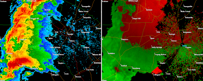
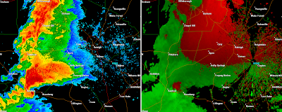
Below are radar images from the Raleigh area radar as the storm progressed from near Sanford, through Raleigh to just past the Rolesville area (in the vicinity of the last known "on ground" tornado report). The left half of each image shows the radar in reflectivity mode (i.e., rain, hail, etc.), while the right half of each image shows the radar in velocity (wind motion) mode. Times are noted below each image (click to enlarge):
18:59 GMT (2:59 PM EDT)
19:03 GMT (3:03 PM EDT)
19:08 GMT (3:08 PM EDT)
19:13 GMT (3:13 PM EDT)
19:17 GMT (3:17 PM EDT)
19:22 GMT (3:22 PM EDT)
19:26 GMT (3:26 PM EDT)
19:31 GMT (3:31 PM EDT)
19:36 GMT (3:36 PM EDT)
19:40 GMT (3:40 PM EDT)
19:45 GMT (3:45 PM EDT)
19:49 GMT (3:49 PM EDT)
19:54 GMT (3:54 PM EDT)
19:59 GMT (3:59 PM EDT)
20:03 GMT (4:03 PM EDT)
20:08 GMT (4:08 PM EDT)
20:12 GMT (4:12 PM EDT)
20:17 GMT (4:17 PM EDT)
Remember, when examining the velocity data, greens show winds blowing toward the radar site, while reds show winds blowing away from the radar site. The radar site is located toward the right hand side of the image, where the "KRAX" is shown in light blue.
As you can see by examining the radar data, the "Sanford to Raleigh" supercell exhibited all of the classic radar signatures that you'd normally associate with a severe, tornadic thunderstorm.
I'll make another update to this post once the NWS storm survey data comes in.


5 comments:
Great post! Thanks for the detailed time lapse radar images!
This is really a nice post. Thanks for all the great info and the map
Anonymous & Dan, thanks! I'm glad that you found the post informative. By the way, anonymous, the radar imagery is captured using GRLevel2. You can download that program online for a free trial or purchase at www.grlevelx.com.
Thank you; a job well-done!
jarles in raleigh I was paralleling the storm as it came into Raleigh, and have clear pics of the storms underbelly from about 1/2 mile. I could see clear air under the whole cloud structure. As I managed to misjudge and drove smack dab in the middle of this tornado, I was lucky to have all my car windows except my rear blow outward. Anyway, I think the city buildings blocked inflow on the west side, and very little roof damage occurred after initial hit at South Saunders St.It wasn't until leaving downtown raleigh that the storm picked up roofs and leveled houses.I think the storm stayed somewhat above ground level in Raleigh, as most damage was from trees and power poles.
Post a Comment