
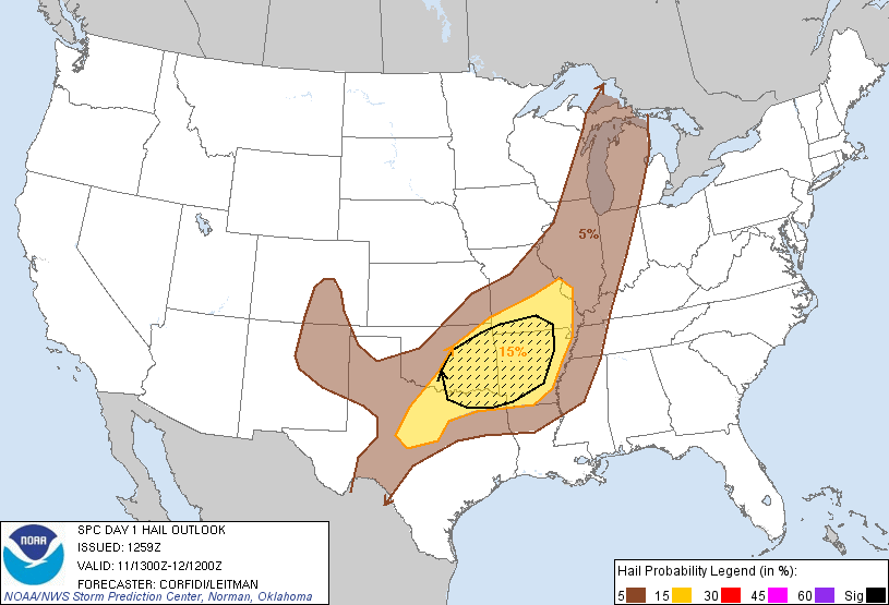
Above is the latest severe weather outlook from the Storm Prediction Center (SPC) in Norman, OK. Severe thunderstorms are forecast today within the yellow shaded areas on the image.
A line of strong to severe thunderstorms is currently moving Southeast across southern Missouri, toward northern Arkansas. Strong, possibly damaging straight line winds and hail to near severe limits are likely with this line as it progresses to the South and Southeast during the day today. The large hail potential will increase during the afternoon as the atmosphere heats up.

Elsewhere, additional thunderstorm development is forecast to take place further to the Southwest along a weak frontal boundary across central and eastern Oklahoma and parts of northwest Texas by mid to late afternoon and into this evening.
Large hail, some perhaps exceeding 2 inches in diameter, and damaging winds will be the primary threats. An isolated tornado or two cannot be ruled out, particularly with any well organized storms during the initial phases of development.
The highest risk of very large hail will exist within the black hatched area on the image below, which includes the Tulsa, Oklahoma City, Ft. Smith and Little Rock areas:
If you live across this region, please remain alert for the latest weather information throughout the day. Take the time now to review your severe weather safety and preparedness tips. Identify your best sheltering option so that you can move there quickly if threatening weather is observed or a warning issued.
We have posted the Springfield, MO high resolution radar sector on the right hand side of the blog homepage so that you can monitor current active weather in that region. We'll also add a sector over Oklahoma later today once storms begin to develop.
For more information, including "live blogging" during rapidly changing weather events, please be sure to follow me on facebook and/or twitter:


No comments:
Post a Comment