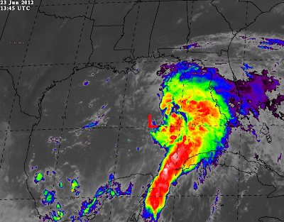
The tropical disturbance that we've been talking about for the past few days continues to organize over the Gulf of Mexico, and recent trends indicate that it is likely already a Tropical Depression, and very close to becoming Tropical Storm Debby.
The center of the disturbance is currently estimated (by satellite) to be located about 350 miles South of Pensacola, FL. The last few observations from a data buoy located about 130 miles East/Northeast of the center have indicated a steadily falling pressure (as noted by the purple arrow on the image below), and the most recent observation noted a wind gust to 40 mph (as noted by the red circle on the same image). Both sustained winds and gusts have been increasing steadily for the past few hours as well:
An Air Force Hurricane Hunter aircraft is scheduled to investigate the system this afternoon. I think this may well be a situation where we go immediately from "disturbance" to Tropical Storm, if the recent trends continue.
Folks along the Gulf Coast, particularly the northern and eastern Gulf Coast, should keep a very close eye on the latest developments with this system today.
For additional details including the latest satellite and radar imagery and loops of this system, please visit this dedicated page on our sister site, WeatherGuidance.com.
For more information, including "live blogging" during rapidly changing weather events, please be sure to follow me on facebook and/or twitter:


No comments:
Post a Comment