A localized severe weather outbreak is forecast later today into early tonight across portions of the northern Plains and northern Mississippi Valley region. Severe thunderstorms are forecast within the yellow shaded area on the above image, with the highest risk within the red shaded area.
All modes of severe weather will be possible across this region this afternoon and evening, including tornadoes, large to very large hail, and damaging wind gusts. The area with the highest risk of tornado development is shown in yellow on the image below, with an elevated threat within the larger brown and green shaded areas as well:
Damaging straight line wind gusts are likely with some of the severe storms within the red shaded area on this image:
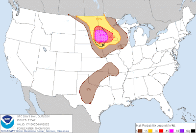
...and very large hail, some in excess of 2 inches in diameter, is likely within the lavender and red shaded, black hatched area on the image below:
If you live across the severe weather threat areas for today, please remain on the alert, particularly during the mid afternoon through mid evening hours. Listen to NOAA Weather Radio, local media or another trusted source for the latest information and possible warnings. Take a few moments early in the day to identify and prepare your best sheltering option, and be prepared to move there quickly if threatening weather is observed or a warning is issued.
For more information, including "live blogging" during rapidly changing weather events, please be sure to follow me on facebook and/or twitter:


No comments:
Post a Comment