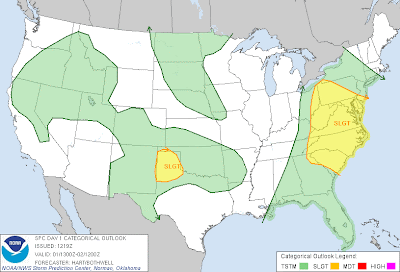
Severe thunderstorms are forecast within the heavily populated "I-95 Corridor" from the Carolinas up into the Nation's Capital today, as shown by the yellow shaded area on the above image.
Large hail and damaging wind gusts will be the primary threats, however there is an area where conditions may also favor isolated tornadoes from more organized cells, as indicated by the yellow shaded area on the image below (which includes the Baltimore and Washington DC Metro areas as well as Richmond, VA):
Severe storms are forecast to develop and increase along and ahead of a frontal boundary during the afternoon, near the Western edge of the severe weather outlook area. The activity will then move and develop East/Northeastward into the evening hours.
As mentioned above, damaging wind gusts will be one of the primary threats today, especially within the red shaded area on the image below:
Another pocket of severe weather is forecast over the High Plains of the Texas Panhandle region. Isolated to scattered thunderstorms are expected to form in this region by late afternoon and continue into the evening. Large hail, damaging wind gusts and an isolated tornado are possible in this region.
If you live in or near any of the severe weather threat areas for today, please remain alert and listen for later statements and possible warnings. Make sure to identify your best sheltering option and be prepared to move there quickly if threatening weather is observed or a warning issued.
For all of the latest severe weather updates throughout the day, visit the Severe Weather Headquarters page at our sister site, WeatherGuidance.com. New content is being added to this page daily, so check back often for updates. We will also feature zoomed-in local radar sectors in particular areas once severe weather gets underway later today.
For more information, including "live blogging" during rapidly changing weather events, please be sure to follow me on facebook and/or twitter:


No comments:
Post a Comment