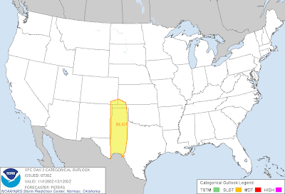
As mentioned in a post yesterday, conditions are shaping up to make this a very active severe weather week across the central and southern Plains. The threat will begin across Oklahoma and northwest Texas today (see this post for details), and will continue right through Saturday...
The severe weather outlooks for Tuesday through Saturday are shown below. The severe weather threat for each day is within the color coded area described below each image:
Tuesday - Yellow Shaded Areas
Wednesday - Yellow Shaded Area
Thursday - Red Shaded Area
Friday - Purple Shaded Area
Saturday - Green Shaded Area
Very large hail, damaging winds and tornadoes are possible each day in the indicated areas. It currently appears that the highest risk of tornadoes will take place toward the end of the week, in the Thursday through Saturday time frame. Unfortunately, this will also correspond with the period during which the severe weather threat will spread into more heavily populated areas.
If you live across this region, please remain weather alert this week. Review your severe weather safety and preparedness tips now. Make sure that you have a safe sheltering location selected prior to the arrival of a threat to your area.
It appears that the threat of severe weather may well continue into the late weekend and early next week, and spread even further Southward in Texas during that time.
Stay tuned for updates on this situation throughout the week...
If you enjoy the blog, please click on the icons below to "Like" my facebook page and/or follow me on twitter. You'll find posts at these locations that aren't always on the blog, especially during rapidly changing weather situations...


No comments:
Post a Comment