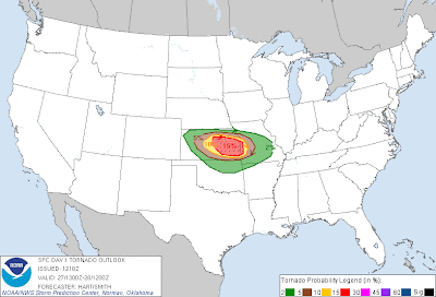
A severe weather outbreak is likely across a relatively small geographic area later today and tonight. The primary risk will extend from central and eastern Kansas into western and central Missouri. Severe storms are possible anywhere within the yellow shaded areas on the above image, with a pronounced risk of very large hail, damaging winds and a few strong tornadoes within the red shaded area.
Thunderstorms currently moving across western Kansas may reorganize and/or intensify by midday and into this afternoon as the atmosphere heats and becomes more unstable over central Kansas. Additional thunderstorm development will take place by midday to early afternoon along a dryline and warm front in central and/or southcentral Kansas. This activity will then move and/or develop Eastward into the late afternoon and evening hours.
Very large hail, in excess of 2 inches in diameter, is possible with this activity, especially within the red and lavender shaded and black hatched areas on the image below:
The potential will also exist for a strong and/or long track tornado or two, especially within the red shaded and black hatched area on the following image:
This pronounced risk of severe storms includes the cities of Wichita, Salina, Topeka, Manhattan, Lawrence, Emporia and Chanute.
If you live across this region, pay particular attention to the weather later this afternoon and this evening. Take the time now to review severe weather safety and preparedness tips. Be sure that you have identified your best sheltering option, and be prepared to move there quickly if severe weather is observed or a warning issued.
If you enjoy reading the blog, please click on the icons below to "Like" my facebook page and/or follow me on twitter. You'll find posts at these locations that aren't always on the blog, especially during rapidly changing weather situations...


No comments:
Post a Comment