
As we've been talking about for the last day or so, a widespread severe weather event continues to appear likely for much of the Ohio Valley, Northeast and southern New England today and early tonight. Above is the latest severe weather outlook from the SPC in Norman, OK. Severe storms are possible anywhere within the yellow shaded area, with the highest risk within the red shaded area on the image.
Thunderstorms continue from overnight activity across portions of the Great Lakes this morning. New development of a more organized nature is forecast to take place along and near a surface frontal boundary from Indiana into Ohio by midday or early afternoon, with the activity then moving and/or developing East / Northeastward with time into the afternoon and evening hours.
Damaging wind gusts will be the primary threat across the region, some of which may become significant and/or widespread. The greatest risk of damaging wind gusts will be within the red and lavender shaded areas on the following image:

The potential exists for some of the wind gusts to exceed 75 mph and cover relatively widespread areas within the black hatched portion of the same image. This elevated risk of significant and/or widespread wind damage includes the cities of Cincinnati, Columbus, Pittsburgh, Philadelphia, Scranton, the New York City area and Springfield, Mass.
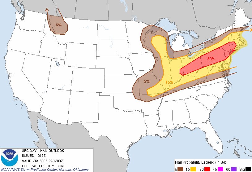
Large hail can also be expected with some of the storms this afternoon and evening, especially within the red shaded area on the following image:
A few tornadoes are also possible, particularly with any storms that are able to remain relatively isolated and become well organized. The highest chance of tornado development, at this time, appears to be located in a relatively narrow corridor extending from northeast Pennsylvania and far southeast New York, into adjacent portions of Connecticut and northern New Jersey, as shown by the brown shaded area on the image below:

If you live across the severe weather threat areas outlined above, please remain alert today. Listen to NOAA Weather Radio, local media or another trusted source for the latest information, watches and warnings. Be sure to identify your best sheltering options at home and work, and be prepared to move there quickly if threatening weather is observed or a warning is issued.
Elsewhere, a more isolated to scattered threat of severe weather is forecast within the yellow shaded area on the image at the top of the post. This includes a narrow corridor from Oklahoma into southern Missouri, northern Arkansas and the middle Mississippi Valley region. The potential exists for "pulse" type severe weather across this region, meaning that storms develop, intensify rather quickly, and then dissipate almost as quickly. This type of activity can generate strong, damaging wind gusts especially as the storm peaks and then dissipates. The primary threat across this area will take place during the peak heating of the afternoon and early evening.
For more information from the Original Weather Blog, including "live blogging" during rapidly changing weather events, please be sure to follow me on facebook and/or twitter:


No comments:
Post a Comment