Friday, June 15, 2012

International Tornadoes This Week: Italy and Poland


I've come across two International tornado videos from earlier this week.

The first was a very impressive tornado/waterspout near Venice, Italy (above), which took place on Tuesday, June 12th.

The second (below) took place on June 11th near Sulechow, Poland (which is in far western Poland near the German border):


I have not seen any reports of significant damage or injuries in association with either of the tornadoes, which is certainly good news.

For more information, including "live blogging" during rapidly changing weather events, please be sure to follow me on facebook and/or twitter:
 

Another High Plains Severe Threat Today...


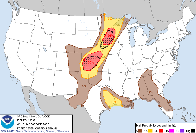
Severe thunderstorms will develop across the high plains of the central and northern U.S. again this afternoon and into this evening.  The highest risk for severe weather is generally within the yellow shaded area on the above image.

Large hail and damaging wind gusts will be the primary threats in this region, although an isolated tornado cannot be ruled out.

Elsewhere, strong to locally severe storms are possible across a broad region of the central third of the U.S., as well as portions of central and southern Florida.  This threat generally applies to the brown shaded areas on the image below:


In these areas, most of the storms will stay below severe levels, however a few may produce hail and/or wind gusts at or near severe limits during the peak heating hours of mid to late afternoon through mid-evening.

If you live in the severe weather threat areas for today, please remain alert and be prepared to move to a safe location if threatening weather is observed or a warning is issued.

For more information, including "live blogging" during rapidly changing weather events, please be sure to follow me on facebook and/or twitter:
 

Carlotta Now A Hurricane; Threatens Mexico...


As expected, Carlotta has become a hurricane in the Eastern North Pacific this morning. The system is currently moving toward the Northwest to North- Northwest and will spread increasing impacts along the Mexican coast throughout the day today and into the weekend.

  Latest Image from the Puerto Angel Radar Site in Mexico

Persons with interests along the Mexican coast from Puerto Angel through Acapulco should be prepared for tropical storm and/or hurricane conditions beginning later today and continuing into the weekend.

For all of the latest on Carlotta, please visit the dedicated page at Tropical Weather Headquarters on our sister site, WeatherGuidance.com.

For more information, including "live blogging" during rapidly changing weather events, please be sure to follow me on facebook and/or twitter:
 

Thursday, June 14, 2012

Monster Hailstorm Strikes Dallas, TX on June 13, 2012...


A widespread, very damaging hailstorm took place across mainly central and eastern portions of the Dallas/Ft. Worth Metroplex yesterday evening, June 13, 2012.

After viewing the ground truth reports and radar data, I'm convinced that this storm will rank right up there as one of the most costly in Dallas history.  (Update 6/15/12:  An insurance trade group in Texas estimates that total insured losses may reach $1.5 to $2.0 billion).


Below is a photo and video montage that we put together on Storify at our sister site, WeatherGuidance.com.

Severe Weather Threat From Central Plains to Northern Mississippi Valley Today...


Severe thunderstorms are forecast across a fairly large area extending from the central Plains into the northern Mississippi Valley region today, as indicated by the yellow shaded area on the above image.  There is also a risk of severe storms over southeast Texas and southwest Louisiana.

The greatest threat today will be that of large hail, potentially very large in some areas.  The atmosphere across the Plains and Upper Mississippi Valley region is forecast to become extremely unstable this afternoon, which will support the production of very large hail in many storms.  Hailstones may exceed 2 inches in diameter in some places, especially within the red shaded and black hatched areas on the image below:


There is also a threat for damaging wind gusts and a few tornadoes, with the tornado threat being highest across the northern Mississippi Valley region, especially during the first few hours of thunderstorm initiation when storms are more isolated.  This tornado threat includes the Minneapolis area.

Across southeast Texas and southwest Louisiana, a few thunderstorms may become severe this afternoon and evening, with large hail and locally damaging wind gusts the primary threat.


If you live across the severe weather threat areas for today, please remain alert.  Listen to NOAA Weather Radio, local media or another trusted source for the latest information and forecasts.  Be prepared to seek shelter quickly if threatening weather is observed or a warning is issued for your area.


For more information, including "live blogging" during rapidly changing weather events, please be sure to follow me on facebook and/or twitter:
 

Tropical Storm Carlotta Forms in Eastern North Pacific

Current Visible Satellite Image

Above is the latest visible satellite image of Tropical Storm Carlotta, which formed last night in the Eastern North Pacific.

Carlotta is expected to strengthen to a hurricane by tomorrow, and will threaten the Mexican coastline on Friday evening and night.

For all of the latest on Carlotta, please visit the dedicated page at Tropical Weather Headquarters on our sister site, WeatherGuidance.com.

For more information, including "live blogging" during rapidly changing weather events, please be sure to follow me on facebook and/or twitter:
 

Wednesday, June 13, 2012

Severe Storms Possible Western High Plains Again Today...


Severe thunderstorms are forecast on the High Plains of West Texas and Eastern New Mexico again today, as well as in parts of the Dakotas.

The areas shaded in yellow on the above image have the greatest risk of severe weather, most of which will consist of large hail and damaging winds.  A few isolated tornadoes are also possible, particularly during the first few hours of thunderstorm generation later this afternoon and this evening.

If you live in or near these areas, please remain alert and be prepared to seek shelter if threatening weather is observed or a warning is issued for your area.


For more information, including "live blogging" during rapidly changing weather events, please be sure to follow me on facebook and/or twitter: