Saturday, June 30, 2012

Severe Derecho Struck the Midwest/Ohio Valley to the Mid-Atlantic Yesterday...


The above radar loop (courtesy of the College of DuPage Nexlab), shows the progression of a severe "derecho" from the Midwest to the Ohio Valley, and all the way to the Mid-Atlantic Coast yesterday afternoon and evening.

A derecho is a severe windstorm that, by definition, produces damaging winds in excess of 60 mph along a swath of at least 240 miles in length.  Radar signatures associated with a derecho often take on an arc or bow configuration, hence the term "bow echo", as is shown throughout most of the radar loop above.

Viewed from the ground, a large, arcing shelf cloud often flows out ahead of the strong winds, as captured by this impressive photo yesterday on the southeast side of Chicago (via twitter, unknown photographer):


A video was posted on YouTube showing another great perspective of the developing shelf cloud near Elk Grove Village, IL:


All in all, this particular derecho traveled a distance of over 700 miles in about a 10 hour period of time yesterday, producing widespread 70-80 mph wind gusts, with several reports of 90+ mph wind gusts at the peak of the event.

Wind damage was widespread, with trees and power lines being particularly hard hit.  It has been reported that nearly 2 million people were without power at the peak of the storm.  At one point, just over 1.2 million were without power in the Baltimore/D.C. area alone.


It often takes several weeks to clean up the damage after such an event, especially with the widespread amount of tree damage that appears to have taken place in this particular case.

Unfortunately, I've seen documentation of 10 deaths in association with this event so far (6 in Virginia, 2 in New Jersey, and 1 each in Maryland and Ohio).  While specific details haven't been offered, serious injuries and/or deaths often take place in this situation as a result of falling trees and/or tree limbs or other wind driven debris.  That's why it is always best to seek shelter indoors and stay away from windows during a strong wind storm.  In fact, a derecho of this strength can cause just as much damage as a low end tornado, and I recommend treating the situation accordingly and taking tornado shelter precautions just to be safe.

For more information, including "live blogging" during rapidly changing weather events, please be sure to follow me on facebook and/or twitter:
 

Wednesday, June 27, 2012

Debby Finally Departing Florida; Watching a Wave in the Atlantic


The center of Tropical Depression Debby has finally moved back out over water in the southwest Atlantic this morning, and will continue to pull the rains out to sea and away from Florida (aside from the daily sea breeze type activity, etc.).   I'm sure the water logged folks in the sunshine state are glad to see that finally happen...

Meanwhile, out in the far reaches of the tropical Atlantic, a tropical wave is being monitored for gradual development as it moves slowly Westward over the next few days (yellow circled area on the image below):


I apologize for the lack of posts/updates the last few days.  I've been on the road.  I'll be back in the full swing of things by Friday with a couple of updated posts to come concerning the continued tornado recovery and rebuilding of Joplin, MO.


For more information, including "live blogging" during rapidly changing weather events, please be sure to follow me on facebook and/or twitter:
 

Monday, June 25, 2012

Tropical Storm Debby Still Dumping Rain on Florida...


Tropical Storm Debby continues to dump heavy rain on Florida...a trend that is likely to continue today. At 7am CDT, the center of Debby was located about 90 miles South/Southwest of Apalachicola, Florida.  The "official" National Hurricane Center advisory states that Debby is stationary, but satellite imagery indicates that it is drifting East/Northeastward very slowly, a trend that has continued since yesterday.

Quite a bit of dry air has been drawn into the system in the last 6-12 hours, which has resulted in a general decrease in the coverage and intensity of the rain over Florida.  Daytime heating today will likely cause an increase in thunderstorm activity, some of which will produce locally heavy rainfall.

If Debby doesn't reorganize during the day today, and the dry air continues to intrude into the system, she could weaken to a Depression before making official landfall in Florida.  (Remember that landfall occurs when the center of the system moves onshore - which is kind of irrelevant in this case because the effects of Debby have been felt in Florida for days now, and will continue until she moves back out over the Atlantic).

The latest Hydrometeorological Prediction Center (HPC) forecast calls for an additional 6-12 inches of rain across northwest Florida and the panhandle.  Locally heavier amounts are also possible in stronger storms:


The steering currents around Debby continue to be rather weak.  If she does not become fully ingested by the trough of low pressure over the Eastern U.S. (which is what caused her Northeast turn yesterday), she could continue to wobble around the northeastern Gulf of Mexico, hammering Florida with more heavy rain through Wednesday or possibly even Thursday.  Time will tell for sure, but folks in this region should continue to take precautions, especially if you live in a low lying or flood prone area.

The official NHC track calls for Debby to move slowly Northward, making landfall somewhere in the panhandle of Florida.  I am still of the opinion that a more Northeastward drift is likely (and that appears to be what we're seeing currently on satellite imagery), which would mean more of a northwest Florida or Florida bend landfall.  Again, this is really irrelevant, as the heavier rain and thunderstorm activity will continue to spread across Florida on the Eastern side of the system anyway.

The main thing to watch now is how quickly she'll move ashore and eventually out of the region, giving Florida a much needed break from the rain.  I think the next 12 hours are key.  If a decent move (and I mean even just 5 or 6 mph) to the East or Northeast is not noted, I think the chances are she will continue to spin around the northeast Gulf for a few more days, dumping more rain on Florida.

For additional details including the latest satellite and radar imagery and loops of this system, please visit this dedicated page on our sister site, WeatherGuidance.com.

For more information, including "live blogging" during rapidly changing weather events, please be sure to follow me on facebook and/or twitter:
 

Sunday, June 24, 2012

Update on Tropical Storm Debby


As of 1pm CDT, the center of Tropical Storm Debby was located about 175 miles East/Southeast of the mouth of the Mississippi River, and moving Northeast at 6 mph.

Debby has been moving toward the Northeast for the last 4-5 hours, and there seems little doubt in my mind that it will continue to be drawn into the influence of the trough of low pressure developing over the Eastern U.S. and continue in this general direction over the next few days.  I would, therefore, expect a landfall (of the center) somewhere along the northwestern Florida coast late tomorrow or early Tuesday - but that is really irrelevant, as the state continues to be under siege by Debby right now (more on that in a moment).

The "official" forecast track from the National Hurricane Center continues to shift toward the East, but -at this time- still calls for a landfall in southern Louisiana later this week.  I suspect we'll continue to see the NHC shift their forecast Eastward over time, especially now that more and more of the major computer forecast models are now coming to the same conclusion:


As I mentioned above, regardless of the exact timing of the landfall of the center of Debby, Florida will continue to be hammered by high surf, dangerous rip currents, heavy rain and isolated tornadoes through at least most of Monday.

The latest rainfall forecast from the HPC is calling for widespread amounts of 6-12 inches across much of central and northern Florida through at least early Tuesday.  Localized amounts in excess of 12 inches will be possible in some areas, especially near and adjacent to the yellow shadings on the image:


Numerous tornado warnings have been issued today, and we'll continue to see spin-ups of tornadoes along the Eastern side of the thunderstorm activity associated with Debby through Monday.  While these tornadoes are typically short lived, if they happen to touch down in a populated area, they can still cause damage and injury.

Folks across the northeastern Gulf of Mexico, and especially Florida, southern Alabama and southern Georgia, should continue to monitor the latest information and forecasts concerning Debby.  If you are in central or northern Florida, including the panhandle region, and live in a flood prone area, please move to higher ground as quickly as it is safely possible and ride out the storm there.  Flooding and flash flooding, as well as the water inundation from the Gulf may indeed be the greatest threats with this system (other than the isolated tornado threat, of course).

I will make another post later this evening, or earlier if conditions warrant.  You may also wish to follow me on facebook or twitter (at the links below) for any short updates that I may post there from time to time as anything particularly interesting pops up.

For additional details including the latest satellite and radar imagery and loops of this system, please visit this dedicated page on our sister site, WeatherGuidance.com.

For more information, including "live blogging" during rapidly changing weather events, please be sure to follow me on facebook and/or twitter:
 

Saturday, June 23, 2012

Tropical Storm Debby Forms in the Gulf... Now What?


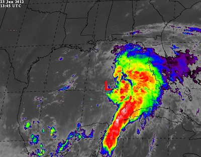
Above is a recent visible satellite image showing the center of Tropical Storm Debby (circled in yellow). At 4pm CDT, the center of the storm was located about 220 miles South of the mouth of the Mississippi River, and was drifting slowly Northward.

An Air Force Hurricane Hunter aircraft found a maximum surface wind of 50 mph in the Northeast quadrant of the storm this afternoon, prompting the National Hurricane Center (NHC) to declare the system Tropical Storm Debby. On a trivial aside, this is the first time in the history of the Atlantic basin that a 4th named storm has developed during the month of June.

As I mentioned in a facebook post earlier this afternoon, the declaration that this system is Tropical Storm Debby is the easy part.  The hard part is figuring out where she'll go next...

To give you an idea as to just how much of a challenge forecasters face with this one, take a look at the composite map below, which shows the various solutions of the "top" computer forecast models over the next 5 days:


We have an Easterly track, a Westerly track, a continued Northerly track, and almost everything in between.  That's enough to make even the most experienced forecaster pull his or her hair out.  So, I would advise you at this point to take any forecast track of Debby with a grain of salt.  For reasons I will attempt to explain below, it will be at least this time tomorrow before any reasonable level of certainty can be expressed in this situation, and that might even be a stretch as well...

The bottom line - at this point - is that if you live along the U.S. Gulf Coast, you will want to keep a close eye on the latest information concerning Debby over the upcoming days.

Getting back to the more recent developments and trends... Overnight last night and into the pre-dawn hours this morning, the center of Debby that we were observing yesterday dissipated and was replaced by the new center that we now see on the satellite image at the top of the post.  The "replacement" of the center of a storm is not uncommon, particularly during the infancy and mature stages of the system.  In this case, however, the replacement may prove to be very significant.

Why, you ask?  The new center is quite a bit further West than the one we were observing yesterday.  It could turn out to be just far enough to the West to prevent the system from being drawn up into the trough of low pressure that is forming in the Eastern third of the U.S. (the same trough that it  appeared would eventually cause the system to turn more toward Florida at about this time yesterday).

If the system fails to be drawn into the trough, it would not likely turn toward the East or Northeast.  That would leave two options:  a continued Northward movement toward the central Gulf Coast, or a Westward turn, toward the western Gulf Coast.

By this time tomorrow, we should have seen a turn toward the East or Northeast if this is going to take place.  If it does not, all bets are off, and folks from the central through western Gulf Coast will be under the gun.

The National Hurricane Center is currently siding with the European forecast models, and calling for a Westward turn and eventual track toward the Texas coast by mid-week next week:


While such a move is possible, I'm not completely sold on it at this point.

Check back tomorrow for more...and remember to watch for that Easterly or Northeasterly wobble between now and then.  If such a move happens, I think the Easterly track solution will win this one (as a disclaimer, I've been favoring that particular track all along).

For additional details including the latest satellite and radar imagery and loops of this system, please visit this dedicated page on our sister site, WeatherGuidance.com.

For more information, including "live blogging" during rapidly changing weather events, please be sure to follow me on facebook and/or twitter:
 

Disturbance in the Gulf About to Become "Debby"...


The tropical disturbance that we've been talking about for the past few days continues to organize over the Gulf of Mexico, and recent trends indicate that it is likely already a Tropical Depression, and very close to becoming Tropical Storm Debby.

The center of the disturbance is currently estimated (by satellite) to be located about 350 miles South of Pensacola, FL.  The last few observations from a data buoy located about 130 miles East/Northeast of the center have indicated a steadily falling pressure (as noted by the purple arrow on the image below), and the most recent observation noted a wind gust to 40 mph (as noted by the red circle on the same image).  Both sustained winds and gusts have been increasing steadily for the past few hours as well:


An Air Force Hurricane Hunter aircraft is scheduled to investigate the system this afternoon.  I think this may well be a situation where we go immediately from "disturbance" to Tropical Storm, if the recent trends continue.

Folks along the Gulf Coast, particularly the northern and eastern Gulf Coast, should keep a very close eye on the latest developments with this system today.

For additional details including the latest satellite and radar imagery and loops of this system, please visit this dedicated page on our sister site, WeatherGuidance.com.

For more information, including "live blogging" during rapidly changing weather events, please be sure to follow me on facebook and/or twitter:
 

Friday, June 22, 2012

Update on Tropical Disturbance in Southeast Gulf of Mexico...


Above is the latest visible satellite image showing a broad area of disturbed weather in the southeast Gulf of Mexico. The actual surface circulation center appears to be just to the Northwest of the tip of the Yucatan Peninsula, and is forecast to be located near the red "L" in the following image at 7pm CDT this evening:


Little has changed since yesterday, insofar as the possible eventual tracks of this system.  It was very disappointing to hear that NOAA cancelled the Air Force Hurricane Hunter flight that was scheduled for this afternoon, as it would have given valuable data regarding the developmental stages of this system, which would have then been fed into the computer models for greater clarity.  They are promising such a mission tomorrow, and hopefully it will come to pass this time.

The majority of the computer forecast models are in two camps, just like they were yesterday.  The first scenario takes the system Northeastward across Florida early next week as a Tropical Depression or Tropical Storm (which would be called "Debby"):


The second scenario would take the system on more of a Northwestward then Westward track, possibly impacting the Lone Star State by mid to late week next week.  Under this scenario, the system would have plenty of time to organize into a Hurricane ("Debby"):


At this point in time, I am still of the opinion (as I was yesterday) that the system will most likely track along or near the path outlined in scenario #1, with Florida most likely to be impacted early next week.  There are two main reasons that I continue to feel this way:

(1).  A broad trough of low pressure is forecast to develop across the Eastern third of the U.S. this weekend.  The influence of this trough on the steering flow would tend to draw the tropical cyclone up into it, turning it more toward the East and then Northeast.

(2).  It is very unusual for a tropical cyclone to turn toward the West after it has moved North of 25 degrees North Latitude during the month of June (not during the other months of hurricane season - just June).  Since 1900 this has happened only 1 time, in association with Hurricane Bonnie in 1986.  That was a very unusual situation where the system came under the influence of a surface boundary that forced it to turn Westward.  There is no such boundary present under the particular situation that we're dealing with now.

For the record, there are also computer model solutions that call for a landfall anywhere in between the above tracks, from Texas to Florida, all along the Gulf Coast.  The majority of the models come to one of the two scenarios outlined above (not quite a 50/50 split, about 60/40, with the Florida solution carrying the higher odds).

This situation will become much clearer as the system continues to organize over the weekend.  If an Air Force mission is completed in the system tomorrow, valuable data will be fed into computer models tomorrow night that would also lead to greater clarity and consensus as well.

As I mentioned yesterday, regardless of the eventual track of this system, folks in Florida can expect widespread, heavy rainfall over the weekend.  Rainfall totals may exceed 6 inches in some areas:


Coastal surf will also be on the increase across the northeast and east-central Gulf over the weekend, producing dangerous rip currents in some areas.

On the weather trivia side of things, if in fact we do get a storm named Debby this weekend (or early next week), this will be the only time since record keeping began (in 1851) that we will have had 4 named storms in the Atlantic Basin by the end of June.

Stay tuned, as much more is to come over the weekend.  For additional details including the latest satellite and radar imagery and loops of this system, please visit this dedicated page on our sister site, WeatherGuidance.com.

For more information, including "live blogging" during rapidly changing weather events, please be sure to follow me on facebook and/or twitter:
 

Thursday, June 21, 2012

Tropical Disturbance Forming in SE Gulf of Mexico...


In a post last week I mentioned that we would need to keep an eye on the Gulf of Mexico for possible tropical development late this week or this weekend.  Indeed, an area of disturbed weather is beginning to show up on visible satellite imagery, as indicated on the image above.

The National Hurricane Center has said that an Air Force Reserve Hurricane Hunter aircraft will fly into this disturbance tomorrow afternoon to get a better reading on things.

Until we have the aircraft data available, we can really only go by computer model solutions, as well as the prevailing atmospheric conditions when trying to determine an eventual path.  Right now, there are two main solutions.  The first brings the system into the eastern Gulf of Mexico through Saturday, then turns it Northeastward across Florida late in the weekend or on Monday.  A second scenario would bring the system North - Northwestward into the central Gulf by Saturday, then turn it Westward, eventually threatening the Louisiana or Texas Gulf Coasts by mid-week next week:


Once the data from the aircraft are fed into the models tomorrow, we should get a better read on the situation, but at this time, I am leaning toward the first scenario as being the most likely to take place.  The main reason for that is a trough of low pressure which is forecast to develop across the eastern third of the U.S. this weekend.  This trough should "draw" the system up toward the North-Northeast under its southern influence, and cause the system to turn toward Florida.

Regardless of the eventual path of this system over the weekend, heavy rainfall will overspread much of central and south Florida through Saturday as showers and thunderstorms increase on the Eastern side of the system.

For additional details including the latest satellite and radar imagery and loops of this system, please visit this dedicated page on our sister site, WeatherGuidance.com.

For more information, including "live blogging" during rapidly changing weather events, please be sure to follow me on facebook and/or twitter:
 

Monday, June 18, 2012

Severe Weather Threat Northern Plains / Great Lakes Region Later Today, Into Tonight...


Severe thunderstorms are forecast across an area from the northern Plains into the Western and Central Great Lakes region this afternoon and into tonight.  Specifically, severe storms are forecast within the yellow shaded areas on the above image, with an elevated risk of large hail and damaging winds within the red shaded area on the same image.  Strong to locally severe storms are possible within the larger, brown shaded area.

Thunderstorms are forecast to develop and/or increase in areal coverage and intensity this afternoon and evening across central and northern Wisconsin.  This activity will move and/or develop Eastward throughout the severe weather risk area into the evening and at least early tonight.  Large hail, damaging wind gusts and a few tornadoes are possible in this region.

Other thunderstorm activity is forecast to develop and/or increase during the afternoon and at least early this evening over the Ohio Valley region (generally within the brown shaded area in that region on the above map).  While widespread severe weather is not forecast in this area, a few of the storms could become locally severe with large hail and strong wind gusts.

Later this evening and into tonight, thunderstorms are forecast to develop as moist, unstable air returns Northward into eastern South Dakota and extreme northcentral/northeast Nebraska.  Despite the fact that this development will occur after sunset and into the overnight hours, some of the stronger storms will have the potential to produce large hail.

If you live across any of the above mentioned areas, be sure to listen to NOAA Weather Radio, local media or another trusted source for later statements and possible warnings.

For more information, including "live blogging" during rapidly changing weather events, please be sure to follow me on facebook and/or twitter:
 

Sunday, June 17, 2012

Widespread (Regional) Severe Weather Threat Across the Northern Plains Today...


A localized severe weather outbreak is forecast later today into early tonight across portions of the northern Plains and northern Mississippi Valley region.  Severe thunderstorms are forecast within the yellow shaded area on the above image, with the highest risk within the red shaded area.

All modes of severe weather will be possible across this region this afternoon and evening, including tornadoes, large to very large hail, and damaging wind gusts.  The area with the highest risk of tornado development is shown in yellow on the image below, with an elevated threat within the larger brown and green shaded areas as well:


Damaging straight line wind gusts are likely with some of the severe storms within the red shaded area on this image:


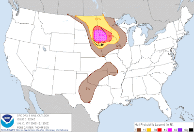
...and very large hail, some in excess of 2 inches in diameter, is likely within the lavender and red shaded, black hatched area on the image below:


If you live across the severe weather threat areas for today, please remain on the alert, particularly during the mid afternoon through mid evening hours.  Listen to NOAA Weather Radio, local media or another trusted source for the latest information and possible warnings.  Take a few moments early in the day to identify and prepare your best sheltering option, and be prepared to move there quickly if threatening weather is observed or a warning is issued.

For more information, including "live blogging" during rapidly changing weather events, please be sure to follow me on facebook and/or twitter:


Saturday, June 16, 2012

Severe Storms Possible Southern Plains to Midwest Later Today...


Above is the latest severe weather outlook for today from the Storm Prediction Center (SPC) in Norman, OK.  Severe thunderstorms are forecast within the yellow shaded area on the image.

A complex of thunderstorm activity in Kansas overnight produced an outflow boundary that is moving Southward into northern Oklahoma this morning.  This boundary will focus scattered thunderstorm re-development later this afternoon and into this evening.  Some of these storms will become severe, with large hail and damaging wind gusts the primary threat.

Elsewhere, several weak surface boundaries are present from Missouri on to the Northeast across the Midwest.  These boundaries will focus thunderstorm development during the afternoon and evening hours, some of which will become strong to severe.  While large hail and damaging wind gusts are the primary threats in this region as well, there is also a risk for an isolated tornado or two, particularly during the first few hours of thunderstorm development.

If you live across the severe weather threat area for today, please remain alert.  Listen to NOAA Weather Radio, local media or another trusted source for the latest information.  Be sure that you've identified a safe sheltering location and be prepared to move there quickly if threatening weather is observed or a warning is issued.

For more information, including "live blogging" during rapidly changing weather events, please be sure to follow me on facebook and/or twitter: