Showing posts with label Severe Weather Updates. Show all posts

Monday, March 12, 2012

Tornado Watch Issued for Michigan, Extreme Northern Indiana...


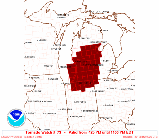
The above Tornado Watch was just issued by the SPC in Norman, OK. It is valid until 11pm EDT and includes the cities of South Bend, Grand Rapids and Lansing.

Strong to severe thunderstorms are developing across the Western and Northern portions of the watch area, and are moving East/Northeastward.  This trend will continue into the evening hours.

If you live in this region, please take the time now to make sure that you have a safe sheltering location and be prepared to go there if threatening weather is observed or a warning is issued for your area.


If you enjoy reading 'The Original Weather Blog', please be sure to "like" our facebook page!

Tuesday, February 28, 2012

New Tornado Watch Central / Southcentral Kansas Until 11pm CST...


The above Tornado Watch was just issued by theStorm Prediction Center (SPC)in Norman, OK. It is valid until 11pm CST and includes the cities of Wichita, Russell, Great Bend, Salina and Hutchinson.

Thunderstorms are developing along and ahead of a surface cold front and dryline across the western part of central Kansas.  This trend will continue as the activity moves and develops toward the East/Northeast this evening.

Large hail and strong, possibly damaging wind gusts are the primary threats, however isolated tornadoes are also possible.

If you live in this region, please listen to NOAA Weather Radio or another trusted source for later statements and possible warnings.  Have a sheltering plan in mind and be prepared to go there immediately if threatening weather approaches your area...


If you enjoy reading 'The Original Weather Blog', please be sure to "like" our facebook page!


Friday, February 24, 2012

New Tornado Watch for the Eastern Carolinas / Virginia...


A new Tornado Watch was just issued for eastern portions of the Carolinas and Virginia. It is valid until 8pm EST.

Please see earlier posts regarding the other tornado watches that continue in effect... here and here.

Folks living all across this region should have their sheltering plans in place and be ready to take cover if threatening weather approaches.

Many of the storms out there today are moving at speeds of 55-65 mph, which gives very little reaction time in some cases.  Make sure that you are prepared ahead of time...


If you enjoy reading 'The Original Weather Blog', please be sure to "like" our facebook page!

New Tornado Watch Issued FL Panhandle into GA and SC...


The above Tornado Watch was recently issued for the counties shaded in red, and is valid until 8pm EST. The other two watches outlined in an earlier post continue in effect until 4pm EST.

Folks living all across this region should have their sheltering plans in place and be ready to take cover if threatening weather approaches.

Another aspect of the severe weather situation to consider today is that the average storm motion is 55-65 mph!  You may have very little reaction time if a warning is issued for your area, so be prepared ahead of time!


If you enjoy reading 'The Original Weather Blog', please be sure to "like" our facebook page!

Tuesday, May 24, 2011

Severe Thunderstorm Watch Issued - Central TX


A Severe Thunderstorm Watch has been issued for portions of central & southcentral Texas, valid until 4am CDT.  This watch includes Austin, Georgetown and Waco.

A line of thunderstorms continues to develop Southwestward along the dryline and may move as far as the I-35 corridor from San Antonio to Austin during the night.

Large hail, damaging winds and dangerous lightning can be expected with this activity.