Showing posts with label Tropical Storm Isaac. Show all posts

Friday, September 7, 2012

Update on "Isaac II / Nadine Wannabe" in the Gulf...


In a post yesterday, I remarked that thunderstorm activity in association with part of the remnants of Isaac in the northern Gulf of Mexico continued to remain well away from the center of circulation.  That trend has continued since then, and continues to hamper the development of the system overall.

The system will be overtaken by a cold front on Saturday and pushed East, bringing an increased threat of rain to portions of an already drenched northern Florida.  Other than that - and some rough surf along the northcentral and northeast Gulf Coast today and Saturday, I expect the affects of this system to be minimal.

With the above in mind, I think the name "Nadine" will be reserved for the next system, which has yet to form somewhere in the Atlantic.

For more information from the Original Weather Blog, including "live blogging" during rapidly changing weather events, please be sure to follow me on facebook and/or twitter:
 

Monday, September 3, 2012

The Tornado Chronicles: Corning, AR Tornado of 9-1-12...


One of the tornadoes spawned by the remnants of Hurricane Isaac was rated EF-2 intensity, which is relatively strong for the type.  The above photo near Corning, Arkansas was taken by Robert Rowland and posted on twitter.

According to the post storm survey completed by the National Weather Service (NWS), the tornado touched down about 1 mile Southwest of the Corning airport and tracked toward the Northeast for approximately 2.5 miles before lifting about 1.5 miles Northeast of the Corning airport.  The maximum path width was 75 yards.

There was significant damage done to hangars at the airport:


The damage in the 2nd photo, which shows the near complete failure of a hangar at the North end of the airport, is primarily responsible for the EF-2 intensity rating.  A 930 pound piece of equipment was also moved nearly one-quarter of a mile away from the building in which it had been stored.

Fortunately the tornado took the path that it did, for had it touched down just a few miles to the East (see map below) it would have tracked through the town of Corning, potentially causing much more damage and injuries.


While the Corning area tornado followed the M.O. of a tropical cyclone induced tornado with respect to its short lifetime, it actually performed in the upper end of the spectrum with respect to intensity.  Most tornadoes generated by tropical cyclones and their remnants rate EF-0 to low end EF-1 intensity.

For more information from the Original Weather Blog, including "live blogging" during rapidly changing weather events, please be sure to follow me on facebook and/or twitter:
 

Saturday, September 1, 2012

Remnants of Isaac Bring Beneficial Rains to Midwest...


As we had hoped, the remnants of Hurricane and Tropical Storm Isaac have produced widespread, beneficial rains across much of the Midwest and middle Mississippi Valley over the last 24-36 hours.  The above image shows the Southern view of observed rainfall for yesterday and last night, and the image below shows the Northern view of the same:


A zoom-in on the Missouri area shows a band of widespread 3-6 inch rains from Kansas City to near Kirksville, MO, and a similar band arcing Southeastward into west-central and central Illinois:


Similar 3 inch (plus) rains fell over portions of eastern Arkansas as well, with the locations in lavender receiving in excess of 6 inches:


Additional heavy rains are instore today, with a 3-4 inch (plus) bullseye centered over central portions of Illinois and Indiana:


All of the above rainfall, and that which is still to come, is taking place across a region that has been severely impacted by drought in recent months:


...so this is a very welcome site indeed!

For more information from the Original Weather Blog, including "live blogging" during rapidly changing weather events, please be sure to follow me on facebook and/or twitter:


Thursday, August 30, 2012

Isaac, Though Weakening, Still Causing Many Problems...


Regular blog readers know that one of my greatest fears all along with Isaac (prior to landfall) had nothing to do with the wind, but the storm surge, and fresh water flooding.  Compounding that fear was the knowledge that the system would likely be moving very slowly, which would significantly extend the duration of the event, even longer than we saw with Katrina 7 years ago. Unfortunately, we continue to see those affects today, and are likely to for several more days to come...

Most recently we've heard of a mandatory evacuation affecting 50-60,000 people to the Northwest of New Orleans along the Tangipahoa River in Tangipahoa Parish (see the general location on the image below):


Officials in the area fear that a dam is close to being breached there, unable to hold back the waters that have been pounding the region from both the sea and the sky for the last 36 hours.  Radar estimates indicate that 15-20 inches of rain have fallen in this general area, and it is still raining at this time (although at a much lighter intensity, thankfully).

A similar order was issued yesterday evening for the southeast New Orleans community of Belle Chasse.  A levee was breached in that area, affecting approximately 3,000 people.  Plaquemines Parish (in which Belle Chasse is located) has been hit particularly hard by Isaac, with numerous rooftop rescues taking place yesterday.  The President of the Parish stated that the situation in his communities was "worse than Katrina".

Water hasn't been the only problem, as widespread wind damage has been reported as well.  Just under 1 million people are without power in Louisiana, which according to the Louisiana Public Utility Commission accounts for nearly 50% of all customers in the state.  Downed trees and other debris are widespread, which will slow the power restoration efforts in many areas.

Below are some new photos of the impacts of Isaac so far, with credits given where the photographer was able to be identified:

LaPlace, LA - Getty Images

Top of a 1 story home in Braithwaite, LA - Associated Press

Braithwaite, LA - Suzy Dinger

Damage in New Orleans - Times-Picayune

New Orleans - James Perry

Gulfport, MS - Tom Winter NBC News

Before & After in Fowl River, AL - Abby Weems

You can also view my post from yesterday for other photos.

Tornadoes have also been a problem in association with Isaac, as is often the case with tropical cyclones.  One county in Mississippi (Harrison) was under 10 different tornado warnings during the day yesterday.

Most tornadoes in association with tropical systems are relatively weak and short lived, but can cause damage, injuries or even death if they strike a populated area.  One tornado in Pascagoula, MS was on the ground long enough to be captured on camera yesterday:


Additional tornadoes are possible today, and a Tornado Watch is currently in effect for portions of Mississippi, Alabama and the western Florida panhandle:


Not all of the news with Isaac is bad, however.  While heavy rains will continue to cause problems across portions of Louisiana and much of Mississippi and western Alabama today, much needed rain will fall over the drought stricken Midwest as the remnants of Isaac spread Northward over the weekend:


For additional information, including the latest satellite and applicable radar imagery, etc., please check out the dedicated page on our sister site, WeatherGuidance.com.

For more information from the Original Weather Blog, including "live blogging" during rapidly changing weather events, please be sure to follow me on facebook and/or twitter:
 

Wednesday, August 29, 2012

Isaac Weakening (and moving) Very Slowy; Significant Impacts Continue...


Based on radar data at 5pm CDT (see below), the center of Tropical Storm Isaac was located between Convent and Donaldsonville, LA.  This is about 50 miles West of New Orleans.  Isaac continues to move very slowly toward the North/Northwest to Northwest at around 5 mph.  Maximum winds have decreased to around 70 mph, which resulted in the "downgrade" to Tropical Storm earlier this afternoon.  Despite the change in classification, Isaac is still causing widespread problems across the state of Louisiana as well as southern Mississippi, and this will continue into the night and early Thursday.


As you can see on the most recent radar presentation, the eye has become very small and will continue to slowly dissipate this evening.  Strong winds of 50-60 mph with gusts of 70-80 mph continue mainly to the East and Northeast of the center.  Winds will remain strong throughout the evening, but will gradually decrease into the 40-50 mph with gusts of 50-60 mph range by Midnight.

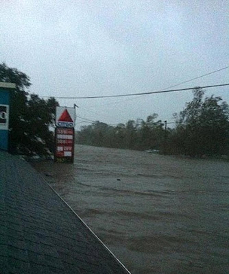
In addition to the widespread damaging winds of the last 12-18 hours, the other big story with Isaac, just as we feared, has been the pro-longed storm surge and related flooding.  I could bore you with some factual details, but I think the pictures below tell the story much more effectively (credit given when the photographer was known):

Pass Christian, MS - Riann Martin

Gulfport, MS - Riann Martin

French Quarter - Tripp Remmington III

Gas Station in Braithwaite, LA - Associated Press

McDonald's Near Braithwaite, LA - Charley Louise

Taken from 3rd story of a Braithwaite, LA Home - Unknown Photographer

More Rooftops in Braithwaite, LA - Lolo Jones

Lake Pontchartrain Overflowing - AP Photo

Beau Rivage Resort in Biloxi, MS - Sun Herald

Laplace, LA - Richard McDougle

Historic Home Destroyed in New Orleans - Melissa Perry

In addition to the persistent (though gradually decreasing) strong winds, additional heavy rainfall is on tap for much of the region tonight.  Here is how the rainfall is forecast to break-down for the periods 7pm to 1am CDT, 1am to 7am CDT and 7am to 1pm CDT tonight and tomorrow, respectively:


While several tornadoes have been reported today, it is unclear how much damage was caused by any actual tornadoes vs. the ongoing windstorm.  A Tornado Watch continues across much of the region until 12 Midnight this evening, and may be extended and/or reissued as Isaac continues to slowly move Northward:


For additional information, including the latest satellite and applicable radar imagery, etc., please check out the dedicated page on our sister site, WeatherGuidance.com.

For more information from the Original Weather Blog, including "live blogging" during rapidly changing weather events, please be sure to follow me on facebook and/or twitter: