Showing posts with label Winter Weather Outlook. Show all posts

Monday, February 27, 2012

Significant Winter Storm to Impact Northern Plains Tuesday-Wednesday...


The same storm system that will bring a threat of severe weather to the central and southern Plains into the Mississippi River Valley tomorrow afternoon and night will bring widespread snow, some heavy, to the northern Plains at about the same time.

The above image shows current Winter Weather Watches, Warnings and Advisories across the region.  Winter Storm Warnings are in effect for the pink shaded areas (including the Minneapolis-St. Paul area), while a Blizzard Warning is in effect for the orange shaded areas over the Dakotas and west-central Minnesota.

Heavy snow will fall across the northern and central Rockies tonight and the first half of Tuesday:

Probability of 8+ Inches of Snow thru 6pm CST Tuesday

...and then spread out into the adjacent Plains by Tuesday evening and night:

Probability of 8+ Inches of Snow 6pm CST Tuesday-6pm Wednesday

This winter has been relatively quiet across much of this region, snowfall wise.  If you live across the warning areas, make sure that you're ready to stay indoors until the worst of the weather passes your area.  Take the time now to purchase needed supplies and stock your severe weather emergency kit.


If you enjoy reading 'The Original Weather Blog', please be sure to "like" our facebook page!

Friday, February 17, 2012

Update on Major Storm System for This Weekend: Severe Weather & Snow...


A strong storm system in the middle and upper atmosphere is spinning around to the South of the Arizona border this morning (as shown by the yellow circled area on the above water vapor satellite image).  Pieces of energy and stronger winds aloft are already spreading well out ahead of the system as indicated by the yellow arrows.

This system will bring a variety of weather, from heavy rain and severe storms in the South, to heavy snow in portions of the mid-Atlantic and/or Northeast as we progress into the weekend.

For later today and especially tonight, widespread shower and thunderstorm activity will break out ahead of the system over much of Texas and adjacent portions of Louisiana.  Rainfall amounts of 1-2 inches will be widespread, with locally heavier amounts of 2-4+ inches in association with some of the stronger and more persistent activity:


Some of the thunderstorms across Deep South Texas and the lower Rio Grande Valley may become strong to locally severe, especially tonight after sunset and into the pre-dawn hours of Saturday as the upper-level storm system approaches.  Large hail and strong wind gusts will be the primary severe weather threats in this region (in addition to the aforementioned heavy rainfall):


Some of the thunderstorms tonight across southcentral and southeast Texas may become strong, with hail just under severe limits the primary threat.  This includes the Austin/San Antonio area and the Houston area.  Widespread severe weather is not expected in this region, with the greatest hazard overall being heavy rainfall that could cause flash flooding in some areas.

On Saturday, the system is forecast to progress Eastward into the lower Mississippi Valley, Gulf Coast and southeast U.S.  As we've been talking about for the past couple of days, the threat for a round of significant severe weather will exist in this region on Saturday afternoon into Saturday night.  While severe thunderstorms are possible anywhere within the brown and yellow shaded areas on the image below, the greatest risk will take place within the red shaded area:


Large hail, damaging wind gusts and tornadoes will all be possible with severe activity in this region.  At this time, it appears that severe storms will develop as early as midday near the western portions of the outlook area, then increase in coverage and intensity as they move East/Northeastward into the afternoon and evening hours.  An overnight severe weather threat, into the pre-dawn hours of Sunday, will exist near the Eastern portions of the outlook area.

The potential will exist for a strong tornado or two, especially across the Louisiana, Mississippi, Alabama and Florida panhandle portions of the red shaded area on the above image.  The wind profiles from the lower through middle levels of the atmosphere will be very supportive of this threat.  The only real question right now is just how unstable the lower-levels of the atmosphere will become during the day Saturday (which will depend on the amount of cloud cover, rain ahead of the storms, etc.).  Depending upon how the instability element develops, this could either increase or decrease the strong tornado threat...so stay tuned for updates on this aspect of the situation.

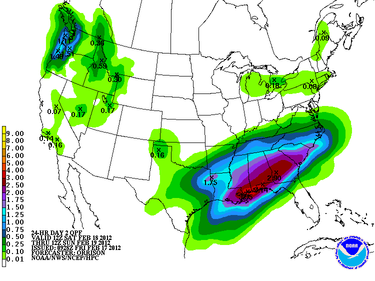
Very heavy rainfall can also be expected across the South Saturday and Saturday Night, which could lead to flash flooding in many areas.  Widespread rainfall of 2-4 inches can be expected, with locally higher amounts possible:


The focus will shift to winter weather as the system moves up into the mid-Atlantic and Northeast region on Sunday.  While there is still some uncertainty as to the exact track that the system will take (which will ultimately affect where the band(s) of heaviest snow will set-up), the forecast models are starting to reach a fair level of consistency.

The consensus of the last few model runs have suggested that the primary "significant" snow band will likely set-up from eastern Kentucky into the Delmarva region (including Washington, DC and Richmond, VA).  Within this band, widespread 3-6 inch accumulations can be expected, with locally heavier amounts of 6-12 inches possible: 


The above image is the forecast probability of snowfall exceeding 4 inches from the HPC.  It is valid for the period 7am EST Sunday through 7am EST Monday.  At this time, it appears that the most likely time period for the heaviest snow would take place from midday through the evening hours on Sunday, spreading from West to East.

Stay tuned for updates on the snowfall forecast as it becomes even more clear how the system is going to track out over the next 24-36 hours...

If you live in the severe weather threat areas outlined up toward the top and middle of the post, please be alert this weekend.  I would suggest that you review severe weather safety and preparedness tips now, that way you have a plan of action in place before severe weather threatens your area.


If you enjoy reading 'The Original Weather Blog', please be sure to "like" our facebook page!

Wednesday, February 15, 2012

If This Model Projection Verifies...Lookout New England on Sunday (and the South on Saturday)!!!


The above image is a screen shot of the latest run of the GFS computer forecast model, valid at 6pm CST (7pm EST) this coming Sunday evening.  Note the intense area of low pressure just off of the Long Island coast (to the immediate Southeast of New York City).  

If this model solution verifies, intense snowfall will take place to the Northwest of the track of the low pressure center, on the order of 14-18 inches (or more):


There are still many uncertainties in place at this time, so watch for more detailed updates as we approach the weekend.  

Needless to say, if you live across the Mid-Atlantic or the Northeast, you'll want to keep a very close eye on the progression of this system for the second half of this coming weekend.

Also, there could be a significant threat of severe weather, including tornadoes, in the Deep South ahead of the system on Saturday and/or Saturday Night.  Stay tuned for updates on this over the next couple of days as well...

If you enjoy reading 'The Original Weather Blog', please be sure to "like" our facebook page!

Friday, February 10, 2012

Cold Air Invading Central/Southern Plains; Arctic Blast on Way to Northeast...


Cold air is spilling Southward behind a cold front into the central and southern Plains and Midwest this morning. The darker, solid yellow line on the above temperature map shows the location of the freezing line as of 6am CST.  The temperature scale (in degrees F) is at the top left of the image.

This is just the leading edge of a very cold, arctic air that will invade portions of the country this weekend.  The following images show the GFS computer model's forecast of the temperature near the surface at 12 hour intervals (roughly corresponding to the times of the high and low temperature each day) beginning 6pm CST today and ending 6am CST Monday.

Keep an eye on the darker purple shaded areas which correspond to temperatures in the single digits above zero (degrees F).  The grey shaded areas within the purple show temperatures forecast to dip int the single digits to around 10 degrees below zero.  The scale in degrees F is located at the right hand side of each image.

The first image is valid 6pm CST today:


...then 6am CST Saturday:


...6pm CST Saturday:


...6am CST Sunday:


...6pm CST Sunday:


...and finally at 6am CST on Monday, the 13th:


Note the punch of bitterly cold air across much of the northcentral Plains and upper Midwest early in the weekend, and across portions of New England late in the weekend.

There will also be an opportunity for a band of locally heavy snow from near or just North of the New York City area, on up into portions of mainly coastal Maine on Saturday.  The image below shows the current HPC forecast of the likelihood for at least 4 inches of snow during the period 7am EST Saturday through 7am EST Sunday:


At least 4 inches of snow is likely within and near the red outlined area on the image, with lesser chances as you proceed into the green and blue outlined areas.

Another clipper will dive Southeast into the central and southern Rockies on Saturday night and Sunday, producing locally heavy snow across portions of mainly southwest and west-central Colorado and extreme northwest New Mexico:


This same system may also produce a swath of wintry precipitation across portions of Kansas and Oklahoma, into adjacent portions of Missouri and Arkansas on Sunday night.  At the moment it appears that the precipitation will generally be light, but we'll need to keep an eye on this.

The overall pattern in the middle and upper atmosphere appears to be evolving into a much more active one as we head into mid and late February.  I'll have more on that in a post later today...


If you enjoy reading 'The Original Weather Blog', please be sure to "like" our facebook page!

Sunday, January 29, 2012

Relatively Quiet Weather Ahead for Much of This Week; Becoming Active S. Rockies/Plains by Friday/Weekend...


The above image is from the GFS computer forecast model, which is forecasting near normal temperatures across much of the Western and Southern U.S. (grey shaded areas) through at least Friday.  Above normal temperatures (red and orange shaded areas) are forecast for much of the upper Mississippi Valley, Midwest and the Northeast during the same period of time.

It will also generally remain dry across most of the country, at least for much of the period Monday through Friday:


It appears that the weather will start to become active again toward the end of the week and into this coming weekend, with a strong upper-level storm system forecast to emerge out over the Southwest and move into the adjacent Plains.

There is still much uncertainty as to exactly how this system will play out for the end of the week and into the coming weekend, but widespread wintry weather is certainly possible across portions of the southern and central Rockies into the central and southern Plains.  Heavy rain and severe storms will be possible out ahead of this system in the warm sector.

If you live from the Rockies of New Mexico or Colorado into the adjacent Plains of Kansas, Oklahoma and northwest Texas, as well as adjacent areas to the East of there, you'll want to keep a close eye on the latest forecasts for late in the week and this coming weekend.


If you enjoy reading 'The Original Weather Blog', please be sure to "like" our facebook page!