
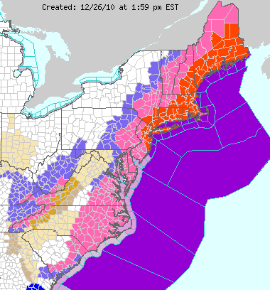
The National Weather Service has issued Winter Storm and/or Blizzard warnings across much of the region through tonight (noted by the pink and orange areas on the map below):
A strong area of low pressure is still in the organization stages off the coast of North Carolina and Virginia. This system is already quite strong but will grow even stronger as the afternoon & evening progress.

By early this evening, the low pressure area will begin lifting North/Northeastward closer to the Long Island corridor, and heavy snows will increase into much of New Jersey, Long Island and New York City. Increased snowfall rates (of 2-3 inches per hour in some cases) along with strong North-Northeast winds of 40-50 mph with gusts to 60 mph will create very dangerous, blizzard conditions across much of the region.
The latest computer forecast model guidance is predicting total snowfall amounts of 15-20 inches to be widespread across much of New Jersey, Long Island and New York City, on Northeast toward the Boston area, through Monday morning.
Below are the computer forecast maps showing accumulated snowfall at 1am EST Monday morning (click to enlarge):

...and 7am EST on Monday morning (click to enlarge):

If the above forecasts verify (which certainly appears possible based on the current trends), then 15-17 inches of snow will have accumulated in the greater NYC area by 7am EST on Monday morning.
Many airlines have already cancelled flights or are delaying flights across the region. Be sure to check ahead if you have any travel plans. The best move, in my opinion, would be to sit tight and ride the storm out and then try to move about again on Tuesday or Wednesday, if you possibly can.
No comments:
Post a Comment