The above satellite image shows 2 areas of disturbed weather in the
Gulf of Mexico and the Tropical Atlantic. The 1st (as indicated by the yellow circled area with the #1) is located just offshore of western Florida, associated with a broad area of low pressure. Middle and upper-level winds are not entirely favorable for this system to organize substantially over the next couple of days, however it bears watching due to the very warm waters in place across the Eastern Gulf of Mexico.
Most computer models currently lift this area of low pressure and associated shower and thunderstorm activity Northward into the Southeast U.S. over the next 5 days:
The 2nd area of disturbed weather (as indicated by the yellow circled area with the #2 on the satellite image) is currently located about 500 miles East/Southeast of the Southern Windward Islands. This area of disturbed weather is associated with a tropical wave that is drifting slowly Westward. Here too, conditions are not very favorable for significant development during the next 48 hours, but it will continue to be monitored as the system moves off toward the West.
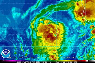
Out in the Pacific, Tropical Depression 3E is about to become Tropical Storm Calvin. The system is currently located about 260 miles South/Southeast of Manzanillo, Mexico (as shown on the latest visible satellite image below), and moving toward the West/Northwest at 14 mph.
Maximum sustained winds are currently at 35 mph, with some higher gusts in squalls.
Computer forecast models continue to show the system moving off toward the West and then Northwest over the next few days:
The system is forecast to become a Tropical Storm (which would be named "Calvin") sometime later this evening or overnight. The latest National Hurricane Center forecast track is below:
At this time, it appears that Calvin will not be able to intensify to Hurricane strength before reaching colder water out toward the West on Saturday. In any case, the system is not forecast to impact any land masses at this time. Heavier than normal surf can be expected for the next 2-3 days along the adjacent Mexican coast.


