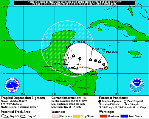
Since we last "talked", Tropical Depression 18 was upgraded to Tropical Storm Rina. A hurricane hunter aircraft is finally scheduled to visit the system again beginning around 1pm CDT, and I think we'll see Rina become a hurricane sooner rather than later.


You can see the strong outflow spirals around most quadrants of the system in the latest visible satellite image above (sorry - I'm away from my illustrator at the moment and can't draw on any images), and the center of the system is now almost completely surrounded by thunderstorm activity - both signs of a rapidly intensifying system.
The "official" National Hurricane Center (NHC) forecast calls for the system to reach hurricane strength tomorrow (I think we're getting there even faster), and they are beginning to share the idea of the more popular short to medium range models in showing the system tracking more toward the Northeast once it reaches the Yucatan peninsula later this week:

The latest runs of the GFDL and HWRF computer models are shown below, and are very close to the idea that the GFS and ECMWF models had (up through Western Cuba, anyway) on the post I made this past Friday:


As I pointed out in that post on Friday, I think there is little doubt that the system will be somewhere near the Western tip of Cuba by the end of this week, but the real question is where will it go once it gets there? There are arguments for it lifting Northeast toward southern Florida, and there are arguments for it being lifted Eastward to the South of the sunshine state.
We should have a much better idea as to the ultimate disposition of the system during the next few model cycles, especially if we can get some quality (and relatively frequent) data from the hurricane hunter aircraft fed into the models.
If you enjoy reading 'The Original Weather Blog', please be sure to "like" our facebook page!