Showing posts with label White Christmas 2012. Show all posts

Wednesday, December 26, 2012

Update on "Christmas Day Snowstorm" - Past, Present and Future...

Here is an update on the snow that took place yesterday and overnight last night / early this morning, and where it is going for the remainder of the day today...

Lots of folks had their white Christmas wish granted yesterday, in a broad swath extending from southern and central Oklahoma into northcentral Texas (including the DFW area which is a rarity), and then on Eastward into Arkansas.  Snow fell late on Christmas evening and overnight last night from northeast Arkansas into the middle Mississippi Valley region.  The snow depth analysis valid at 10am CST this morning is shown below, first on the wide view to give you an overall perspective: 


On this next image I've zoomed in on the band of heaviest snow which fell from Arkansas into the Missouri bootheel:


...and on Northeastward across far southern Illinois and extreme southwestern Kentucky:


Snow is falling heavily at this hour from central and northern Indiana into the Ohio Valley as well as western and southern Pennsylvania:


...where a variety of winter weather warnings are in effect today:


The latest edition of the high resolution NAM computer forecast model is calling for total accumulation in excess of 1 foot across this region through 7am EST on Thursday morning:


When combined with strong and gusty North winds, white out or near white out conditions are possible across much of the region today, and travel is highly discouraged.

For more information from 'The Original Weather Blog', including shorter, more frequent posts during rapidly changing weather events, please be sure to follow me on facebook and twitter:
 
If you are in need of highly customized, site specific weather forecasts and/or storm warnings for your business, school or event, be sure visit my professional webpage at WeatherGuidance.com.

Tuesday, December 25, 2012

Christmas Is Becoming White In Oklahoma / NW Texas...


As you can see on the composite radar image above, snow is falling across much of the western half of Oklahoma and into adjacent portions of the Texas / Oklahoma panhandle at midday this Christmas Day.  The darker purple shaded areas indicate moderate to heavy snow, which combined with increasing winds is producing white-out conditions in some areas.

The orange and pink colored precipitation over southcentral Oklahoma is a mixture of freezing rain, sleet and snow.  This mixture is making for increasingly hazardous travel conditions along I-35 in southcentral Oklahoma.

Snow will continue to develop and increase during the day today, while gradually spreading Eastward across Oklahoma and eventually into Arkansas and southern Missouri.

By 6pm CST today, significant amounts of snow will have accumulated across much of western and southern Oklahoma, with snow continuing to spread Eastward into eastern Oklahoma, Arkansas and far northern Texas.  The high resolution NAM computer model forecast for snow depth at 6pm CST is shown below:


While I agree that snowfall amounts will be generally lighter across northeastern Oklahoma as compared to adjacent areas to the South, I do not agree with the complete lack of snowfall that is portrayed by the model image above.  Most amounts in this region, including the Tulsa area, will average 1-3 inches (heavier in the South and lighter in the North), depending on the exact track of the surface low pressure center later today.

An all out blizzard is likely to form later this evening and tonight across northcentral and northeastern Arkansas, into extreme southeast Missouri and southern Illinois.  The NAM forecast snowfall amounts by 6am CST tomorrow morning reflect that expectation quite well:


The National Weather Service (NWS) has issued a Blizzard Warning from northeast Arkansas into southern Illinois and southwest Kentucky, as shown in orange on the image below.  The areas shaded in pink are under a Winter Storm Warning, with Winter Weather Advisories (for lesser snow amounts) in the lighter purple shaded areas:


For more information from 'The Original Weather Blog', including shorter, more frequent posts during rapidly changing weather events, please be sure to follow me on facebook and twitter:
 
If you are in need of highly customized, site specific weather forecasts and/or storm warnings for your business, school or event, be sure visit my professional webpage at WeatherGuidance.com.


Sunday, December 23, 2012

Update on Christmas Day Snowstorm for Oklahoma, Arkansas & Missouri...

"As advertised" for the last several days, a white Christmas is on the way for a good portion of Oklahoma and Arkansas, as well as at least some portions of southern Missouri.  To make it even better, most of the snow will fall on the big day itself, which is very unusual for this region.

After examining the latest computer forecast model data as well as how the parent storm system is currently organizing over the Pacific Northwest at this time, I believe we can confidently say that snow will be on the ground to some degree or another on Christmas Day at each of the following locations:  Oklahoma City, Enid, Ponca City, Stillwater, Tulsa, Muskogee, Fayetteville, Rogers, Bentonville and Eureka Springs.


I am less confident in predicting accumulating snow in the Ft. Smith (Arkansas) as well as the Springfield, Joplin and Branson (Missouri) areas at this time, as there are still too many questions about exactly how this storm will track as it moves to the East of Oklahoma.  I'll describe the details of the two possible scenarios for these areas below...

As I mentioned in the update yesterday, the primary focus for where the heaviest snow band will set up will be the track of the surface low pressure center on Christmas Day.  The heaviest snow will fall to the North of the surface low track.  The Western and Central portions of the track which would impact Oklahoma is becoming more and more clear, while some question remains as to the Eastern portion of the track which would affect the Arkansas and Missouri snowfall rates.

Right now it appears that the surface low will track along or just immediately to the South of the Red River in Oklahoma and extreme north Texas.  This would produce the heaviest band of snow along and to the North of I-40.  

This scenario has been picked up on the best by the high resolution NAM computer forecast model, which is forecasting accumulating snow, some heavy, centered between I-40 and the Oklahoma/Kansas border through 6pm CST on Christmas Day:


It is beyond this point that some differences in the model solutions remain, with the NAM model curving the surface low toward the East/Northeast, which would then take the heaviest snow into southern Missouri as shown on the forecast image below valid at 12 Midnight CST late on Christmas Day:


Meanwhile, the GFS computer model wants to keep tracking the surface low more directly toward the East, which would result in less snow in southern Missouri and more snow in northern Arkansas, as shown by that model's depiction of the snow cover below, valid at 12 Midnight CST late on Christmas Day:


So, right now if you live in the OKC and Tulsa areas, I'd rest relatively easily (at least as much as you can in this type of tricky forecast situation) in that accumulation of snow appears likely for you on Christmas Day, as well as in most other portions of Oklahoma along and to the North of I-40.

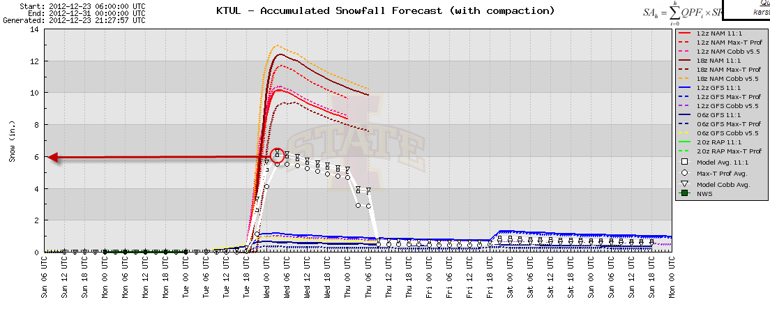
Below are snapshots of the latest computer model forecasts of specific snow depth at Tulsa and Oklahoma City, respectively.  I have circled the "model average" snowfall forecast in red and drawn a red arrow to the resulting amount on each graph:


Note that the computer model forecast average for Tulsa is a healthy 6 inches  of snow (with a maximum of just over 1 foot and a minimum of around 1 inch).  The average for OKC is 4 inches (with a maximum of 6 inches and a minimum of one-half inch).

Again, the exact track of the surface low will be critical in determining, for example, whether Tulsa receives 4-8 inches or 8-12 inches, and so on.  It frankly won't be until the event gets underway until we'll be able to know this for certain, but the current best guess is presented above.

With all of the joy and excitement of snow on Christmas, it will be easy to lose track of the significance of this storm.  The combination of locally heavy snow and strong, gusty winds will produce very dangerous conditions in the affected areas.  All those with travel plans should take some extra clothing and supplies along in case you are "stuck" at your destination longer than you intended to be.  Power outages will also be a distinct possibility across portions of Oklahoma, especially along and North of I-40, so please be prepared for that possibility if you live or will be staying in that region.  More details on those impacts will be forthcoming tomorrow...

Beyond Oklahoma to the East, if you live in Joplin, Springfield and Branson, you want to root for the NAM computer forecast model and its East/Northeastward track of the surface low beyond Oklahoma in order for you to see more accumulating snow.  If you live in northern Arkansas, you are rooting for the GFS model and its more Southern track so that you'll see more accumulating snow than your neighbors to the North would under the other solution.

Stay tuned, I'll post another detailed update tomorrow, with any relevant information that comes in before then likely to be presented in a twitter or facebook post, so please be sure to follow me there if you aren't already.

Special Note on Updates:  this blog post has been linked at several external websites and is getting a lot of "referral" traffic.  If you are reading this post from one of those links, please be sure to go out to the main blog homepage to check for the latest updates, as I will not be updating individual posts as the situation unfolds.  Thanks for visiting!

For more information from 'The Original Weather Blog', including shorter, more frequent posts during rapidly changing weather events, please be sure to follow me on facebook and twitter:
 
If you are in need of highly customized, site specific weather forecasts and/or storm warnings for your business, school or event, be sure visit my professional webpage at WeatherGuidance.com.

Saturday, December 22, 2012

Update on Christmas Day Snow Event and Severe Weather Potential...


The storm system that will eventually produce a white Christmas literally on Christmas Day across portions of the central and southern Plains is slowly becoming organized just off of the Pacific Northwest Coast this afternoon.  The system is forecast to dive Southeastward into the Great Basin tomorrow, then make its way East/Northeast out over the southern Rockies and into the adjacent Plains on Christmas Eve and Christmas Day.

The $64,000 question, as is always the case with a snowfall forecast, is exactly where the surface low pressure center will become well organized and track.  Typically, the heaviest snow falls to the North of the primary surface low track.

Yesterday, the model consensus tracked the primary surface low near the Red River, which would result in heavier snow from northeast Oklahoma into northwestern Arkansas and southern Missouri.  Last night and today's computer models are developing and tracking the low a bit further to the South, across north Texas, which would generally result in a Southward shift of the heavier snow track, across east-central and southeast Oklahoma into western and central Arkansas.

The latest GFS computer model forecasts generally call for the heaviest snowfall to set up along the axis described above, as shown at 12 Noon CST on Christmas Day:


...6pm CST on Christmas Day:


...and at 12 Midnight late on Christmas Day / early Wednesday morning:


The more Southern track of the surface low would produce the greatest chance of a white Christmas from the Oklahoma City area on Eastward, generally along and 50 miles or so to either side of I-40.  While this would still include the Tulsa area as far as the potential for accumulating snow, the heavier amounts of snow would likely fall to the South of both Tulsa and Fayetteville under this scenario.  In such a case, the the McAlester, Muskogee and Ft. Smith areas would likely fall right in the heart of the action.

It is important to keep in mind that there is still some uncertainty, and the exact track of the surface low could still come in closer to yesterday's solution, we'll just have to wait and see how things start to line up especially on Monday / Christmas Eve.

There is still also the potential for a problem with mixed precipitation and/or ice accumulation, mainly along and South of the heavier snow band.  Folks along the Red River from northcentral Texas into southern Arkansas need to pay particular attention for this possibility, as significant travel problems could develop on Christmas Day in this region.

I am also growing increasingly concerned about the potential for locally significant severe weather potential in the "warm sector" of this system on Christmas Day and Wednesday.  The Storm Prediction Center (SPC) in Norman, OK is also keying in on this potential, as shown in the severe weather outlook for Christmas Day shown in red below:


The potential will exist for damaging winds, large hail and even a few tornadoes in this region on Christmas Day, so please pay attention to the weather if you live or have travel plans across the indicated area.

"Stay tuned" for additional updates on this developing winter and severe weather situation both tomorrow and on Monday...

For more information from 'The Original Weather Blog', including shorter, more frequent posts during rapidly changing weather events, please be sure to follow me on facebook and twitter:
 
If you are in need of highly customized, site specific weather forecasts and/or storm warnings for your business, school or event, be sure visit my professional webpage at WeatherGuidance.com.

Friday, December 21, 2012

Christmas Day Snow Event Appears Likely for the Sooner State, Surrounding Areas...

This will be a relatively brief post as detailed information is not yet available, but I did want to give everyone a heads-up that conditions are appearing more and more favorable for a Christmas Day snow event in Oklahoma and adjacent portions of northern Arkansas and southern Missouri.

While there is still some disagreement among the major computer models, most are falling in line with the latest run of the GFS, which is forecasting accumulating snow across much of the Northern two-thirds of Oklahoma, into northern Arkansas and southern Missouri on Christmas Day.

The GFS snowfall forecast images below are valid 12 Noon CST on Christmas Day:


...and at 6pm CST on Christmas Day:


Keep in mind that there will likely be some fluctuation to the North or South with the primary snow band, but this should give you a pretty good idea of where the most likely area(s) for accumulating snow appear to be taking shape for Christmas Day, which right now includes the Tulsa, Joplin and Fayetteville areas.  The potential for accumulating snow in Oklahoma City and Ft. Smith will depend on exactly how the primary snow band sets up, but at this time I would say that there is a "higher than normal" chance of accumulating snow in this region as well.

A band of mixed precipitation and/or ice may also set-up just to the immediate South of the primary snow band.  Right now the most favorable area for this development appears to be in a band from northwest Texas into southeastern Oklahoma and west-central or southwest Arkansas, but this too could shift as details become more clear over the next few days.

Stay tuned, I'll be providing more detailed updates as the situation becomes more clear over the weekend...


For more information from 'The Original Weather Blog', including shorter, more frequent posts during rapidly changing weather events, please be sure to follow me on facebook and twitter:
 
If you are in need of highly customized, site specific weather forecasts and/or storm warnings for your business, school or event, be sure visit my professional webpage at WeatherGuidance.com.