Showing posts with label Winter Weather Update - Northeast. Show all posts

Saturday, October 29, 2011

Winds Building Offshore To Make A Move Inland; Gusts over 60 mph Possible Later...

Media reports indicate over 1,000,000 are now without power in the Northeast - and I hate to tell you, we're just getting started with this, as the winds have yet to come - and the snow will continue to fall in many areas into tonight.

Below is the latest visible satellite image and surface weather observations.  The thin green lines are isobars, or lines of equal pressure.  The closer the isobars are to one another, the stronger the wind is blowing in those areas:


You can see the low pressure center offshore (the closed - though partly off screen - green circle about 200 miles South/Southeast of New York City).  It will continue to grow stronger into the evening and overnight hours, which will result in those isobars getting even more tightly packed, signaling an increase in the winds at the surface level.

The winds at a data buoy located at the entrance to New York harbor (which is about 25 miles off of Long Island and about 40 miles Southeast of Manhattan) are steadily increasing, with the most recent observation (see graphic below) showing steady winds of 40 mph with gusts up to 48 mph.


This trend will continue into the evening hours as the low pressure deepens, with strong and gusty winds spreading inland from North Jersey and NYC up through New England.  

This process is what we call a "bomb", where the surface low deepens very rapidly and over a relatively short period of time.  This is a classic pattern that we'd expect to see with a "Nor'easter" type storm - but certainly not at the end of October!

I would not be surprised to see wind gusts in excess of 60 mph later this evening or tonight across much of this region, particularly along the coastline where there are less trees and buildings to break-up the momentum of the winds coming in off of the ocean.

GFS model forecast valid 11pm EDT this evening.
55-65 mph wind gusts indicated at orange shaded areas.

Even inland, I would expect sustained winds of 30-40 mph with gusts to 50 mph in many areas.  This will bring down trees and power lines that are already under pressure from the weight of the heavy wet snow that has fallen and will continue to fall...

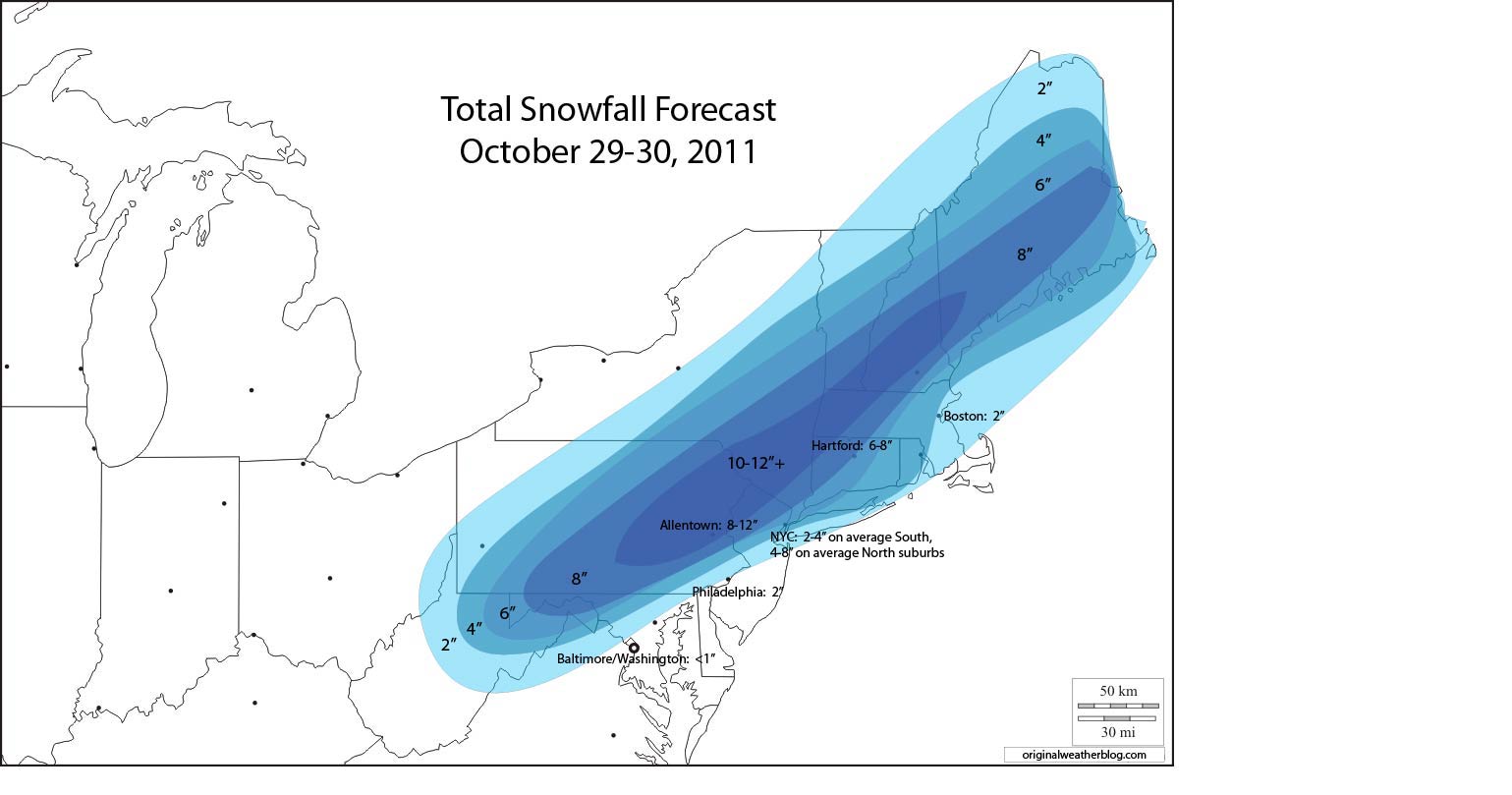
In the precipitation department, things are still pretty much on track from my update at midday.  The image below is the snowfall forecast from that post, please refer to that post for additional details.


If you enjoy reading 'The Original Weather Blog', please be sure to "like" our facebook page!

Trees, Many with Green Leaves, Make This Snowstorm Particularly Interesting - and Hazardous...

One of the elements of the Northeast snowstorm that we've been warning about this week has to do with the fact that many trees across the region are still full of leaves.  As you can see by the photos below that are coming in from around New York City this afternoon, when you add even as little as an inch of heavy wet snow to the mix, the branches get weighed down and, in many cases, come right down:


This scenario is unfolding across most of southeast New York and Pennsylvania and adjacent areas.  Where the limbs come down on power lines, we're also getting reports of widespread power outages.

Martha Stewart even posted a picture on twitter a moment ago of trees coming down on her property in Connecticut:


Keep in mind that strong winds have yet to develop across the region - but they will - which will further add to the problem later this evening and into tonight.  North to Northeast winds of 20-30 mph with gusts as high as 50 mph will develop from North of Philadelphia on up into the New York City area and points to the North and Northeast later this evening and continue into tonight.


If you enjoy reading 'The Original Weather Blog', please be sure to "like" our facebook page!

Record Snowfall Likely for NYC, Hartford, Boston; Near Record at Philadelphia...


Rain continues to mix with and change to snow from West to East across the region at midday, as shown on the latest radar mosaic above.

Surface low pressure is getting wound up offshore of the Mid-Atlantic Coast, as shown on the latest composite surface analysis and visible satellite image below:


The surface low will strengthen rapidly as it lifts North/Northeastward today and into tonight, as shown on this series of GFS forecast model images:


GFS Forecast Valid 2pm EDT Saturday

GFS Forecast Valid 5pm EDT Saturday

GFS Forecast Valid 8pm EDT Saturday

GFS Forecast Valid 11pm EDT Saturday

Precipitation is currently falling in the form of rain in the major cities from Baltimore/Washington on northeastward along the Coast.  Snow is starting to mix in just to the West of the Baltimore/Washington area, and is also beginning to mix in the NYC area.  Based on current trends, I expect rain to mix with and change to snow in the Philadelphia area by mid-afternoon and in the Hartford area by late afternoon.  I expect rain to change to snow in the Providence and Boston areas tonight or early Sunday morning.

Now...on to the record books.  The record October snowfall is 2.2 inches at Washington and 2.5 inches at Baltimore (both set in 1925).  It will be tougher to break those records (based on current forecast trends) than it will be at points to the Northeast, but it still cannot be completely ruled out.  I currently expect 1-2 inches in Western suburbs, and 1 inch or less in the Baltimore/Washington area itself.

The records that appear to be easily breakable later today and/or tonight include:

New York City (Central Park) - 0.8 inches in 1925
Hartford - 1.7 inches in 1979
Boston - 1.1 inches in 2005

It's going to be a close one in Philadelphia.  The record at the airport is 2.2 inches set back in 1925 (the same storm that set the NYC and Baltimore/Washington area records).  I currently have the 2 inch line drawn right through Philadelphia on my forecast, which is shown in the image below:


The image below is the same, but with some of the major city point forecasts included:


As mentioned in posts throughout the week, this will be a heavy, wet snow, with significant potential for widespread tree and powerline stress and/or damage in areas with more than 2 inches of accumulation.  The wind will further aggravate this threat.

As shown on the GFS model forecast images above, North to Northeast winds of 20-30 mph with gusts to 50 mph will become widespread across central and northern portions of the forecast area by this evening.  The winds will be strongest from just Northeast of Philadelphia, on Northeastward across the region.  The high wind threat includes the NYC Metro area, Hartford, Providence, Boston, and interior areas to the West of that line.

Combine the heavy, wet snow with the high winds and a significant threat for power outages will exist across much of the region.

Now that the event is getting underway, future updates will focus on photos and/or videos on the ongoing event, as well as any short-range changes in the snowfall forecast, if needed.  This particular post will not be updated, so please check the blog homepage or the "10 Most Recent Posts" link at the right hand side of the page for future updates...

***Update to add picture regarding Comment by Larry Wirth.  This image was just posted on twitter by a viewer of the Yale/Columbia game:


If you enjoy reading 'The Original Weather Blog', please be sure to "like" our facebook page!

Quick Update on Snow So Far in the Northeast; More Detailed Post to Come...


As expected, snows began in earnest overnight over western Pennsylvania into West Virginia and have since developed Eastward into extreme western Maryland and extreme northern Virginia.  Snow continues to fly across much of this region at this hour, as noted on the radar mosaic image above.

Below is the same image but with snowfall totals for a few locations that have reported so far:


As you can see, most snowfall amounts range from 1-2 inches in the lower elevations to as many as 7 inches or more in the higher elevations.  This is the amount of snow that has fallen - but not necessarily accumulated.  Some melting has taken place due to warm ground conditions, but the snow will begin to accumulate at a more rapid pace during the day as evaporation cools the ground and the snow continues to fall.

Snowfall amounts of 1-2 inches are also starting to come in from around the Pittsburgh area.

The image below was just posted on twitter from State College, PA.  A snowy scene at the stadium at Penn State:


At this point it doesn't appear as though my original forecast from yesterday evening has really changed all that much, but I'm working on a more detailed update with any revisions to the snowfall forecast, this time on a map zoomed in with greater emphasis on the region.  I'll have that post out shortly, so please be sure to check back to the homepage or refresh the "10 Most Recent Posts" menu on the right hand side of the page.


If you enjoy reading 'The Original Weather Blog', please be sure to "like" our facebook page!